Address

Ukraine, Ivano-Frankivsk Region, Verkhovyna District, Yavirnyk village, Pohorilets hamlet, 548

Station manager

Myroslava Mylenka
E-mail: myroslava.mylenka@pnu.edu.ua

Contact Station

E-mail: obserwatorium1938@gmail.com

https://observatorium.pnu.edu.ua/en

Station Features

Opening year: 2017 Status: Open
  • Type of station: Station
  • Operational period – year-round or Month A to Month B: year-round
  • Name of station owner: Vasyl Stefanyk Precarpathian National University
  • Type of owner: University
  • Name of managing institution: Vasyl Stefanyk Precarpathian National University
  • Managing Institution Country: Ukraine
  • Station owner country: Ukraine
  • Partner institution: Yes
  • Partner institution name: University of Warsaw, Poland
  • Station latitude: 48,04691000
  • Station longitude: 24,62735000
  • Country (station location): Ukraine
  • Altitude of station: 2028 m a.s.l
  • Min. altitude within study area: 1000 m a.s.l
  • Max. altitude within study area: 2028 m a.s.l
  • Nearest town/settlement: Shybene village
  • Distance to nearest town/settlement: 11 km
  • Number of residents in nearest town: 300
  • Distance to nearest public transport facility (Airport, Ferry terminal, Train station, Bus station): 15 km
  • Distance to nearest research station: 15 km
  • Type of surface facility is built on: Rock, Soft substrate
  • Climate zone: Alpine
  • Period of measurments for climate data below [year to year]: 2016-2023
  • Mean annual temperature: -9,2 °C
  • Min. Temp. (absolute): -28 °C
  • Precipitation type: Snow, Rain, Hail
  • Snow free period (month to month): May-September
  • Maximum wind speed (absolute): 33 m/s
  • Landscape features Mountains
  • Permafrost zone None
  • Snow and ice on land None
  • Vegetation zone Tree line, Grassland, Alpine heath
  • Wildlife Terrestrial carnivores, Ungulates, Hares, Rodents, Bird colonies
  • Human use Tourism

Facilities

  • Number of staff peak season/summer: 1
  • Number of staff off season/winter: 1
  • Staff able to assist (fieldwork): Yes - if time allows
  • Staff able to assist (workshops): Yes - if time allows
  • Area under roof: 832 m²
  • Max. number of visitors at a time : 20
  • Showers: Yes
  • Power supply – period (from ‘hour’ to ‘hour’ or 24 hours): from ‘hour’ to ‘hour’
  • Power supply - plug type C, F
  • Power sources at station Diesel/oil/gas, Solar
  • Conference room capacity: 2
  • Means of transportation to/from station Walk, Ski, Snowmobile, Tracked vehicle, Truck
  • Compulsory safety equipment Mobile phone, First aid kit
  • Recommended safety equipment GPS
  • Safety equipment available at station Mobile phone, GPS, First aid kit
  • Camping equipment available at station Sleeping matress, Gas/alcohol for cooking
  • Field instruments available at station: Vaisala Automatic Weather Station AWS310
  • Field to station Mobile phone
  • Station to outside world Mobile phone
  • IT Infrastructure Wifi
  • Distance to hospital (estimated time – hours): 8

Science

  • Transnational Access: Yes
  • Remote Access: No
  • INTERACT Virtual Access: No
  • Partner institutions (involved in the operation of the station)
    • Partner institution
  • Climate
    • Snow
    • Rain
    • Hail
  • Landscape and environment
    • Mountains
    • Nunataks
    • Volcano/crater
    • Lava fields
    • Plateaus
    • Moraines
    • Valleys
    • Homothermic Springs
    • Lake
    • Thermokarst lake
    • River
    • Delta/estuarie
    • Fjord
    • Continuous
    • Sea
    • Discontinuous
    • Beach
    • Sporadic
    • Rocky shores
    • Pingos/ice lenses
    • Sea cliffs
    • Other (text)
    • Palsa mires
    • None
    • Ice Caps
    • Glaciers
    • Permanent snow patches
    • None
    • Tree line
    • Polar desert/Semi-desert
    • Gramminoid tundra
    • Shrub tundra
    • Forest tundra
    • Wetlands
    • Peatlands/mires
    • Salt marshes/lagoons
    • Heath
    • Grassland
    • Deciduous forest
    • Terrestrial carnivores
    • Evergreen forest
    • Alpine heath
    • Ungulates
    • Hares
    • Other (text)
    • Rodents
    • Bird colonies
    • Polar bear
    • Whales
    • Seals
    • Fish
    • Settlement
    • Fishing
    • Hunting
    • Forestry
    • Agriculture
    • Tourism
    • Animal husbandry
    • Leisure activities
  • Housing and accomodation
    • Showers
    • Laundry facilities
    • A
    • B
    • C
    • D
    • E
    • F
    • G
    • H
    • I
    • J
    • K
    • L
    • M
    • N
    • O
    • Municipal grid
    • Diesel/oil/gas
    • Wood
    • Solar
    • Wind
    • Water
    • Geothermal
    • Biofuel
    • Other
  • Logistics
    • Electrical and IT technologies
    • Mechanical
    • Metal
    • Wood
    • Plexiglas
    • Other
    • Walk
    • None
    • Tracked vehicle
    • Truck
    • SUV (4x4)
    • Car
    • ATV
    • Zodiac
    • Snowmobile
    • Open boat/Dhinghy
    • Closed boat
    • Bicycles
    • Amphibie vehicle
    • Ski
    • Other
    • Snow shoes
    • KickSledges
    • Other
    • Ski
    • Snowmobile
    • Boat
    • Car
    • Tracked vehicle
    • Truck
    • SUV (4x4)
    • Bus
    • Train
    • Airstrip
    • Scheduled flight
    • Helipad
    • Chartered plane/helicopter
    • Other
    • None
    • Harbour/port
    • Warf/pier
    • Pontoon/float bridge
    • Barges
    • Beach
  • Field equipment
    • PLB
    • VHF
    • HF
    • Satellite phone
    • Mobile phone
    • GPS
    • Weapon/rifle
    • Flare gun
    • Bearspray
    • PLB
    • First aid kit
    • Glacier rescue kit
    • VHF
    • Avalanche rescue kit
    • HF
    • Satellite phone
    • Overnight equipment
    • Other
    • Mobile phone
    • GPS
    • Weapon/rifle
    • Flare gun
    • Bearspray
    • PLB
    • First aid kit
    • Glacier rescue kit
    • VHF
    • Avalanche rescue kit
    • HF
    • Satellite phone
    • Overnight equipment
    • Mobile phone
    • Other
    • GPS
    • Weapon/rifle
    • Flare gun
    • Bearspray
    • Tent
    • First aid kit
    • Sleeping matress
    • Glacier rescue kit
    • Avalanche rescue kit
    • Sleeping bag
    • Cooking equipment and utensils
    • Overnight equipment
    • Gas/alcohol for cooking
    • Other
    • Field power supply available at station
  • Communication and IT
    • Mobile phone
    • VHF
    • Satellite phone
    • Other
    • Satellite phone
    • Mobile phone
    • Internet
    • Other
    • Wireless transfer of data from field site to station
    • Wifi
    • Computers
    • Printer
    • Data storage
    • Statistical tools
    • GIS tools
    • Other
  • Medical facilities
    • Medical facilities
    • Basic
    • Medium
    • Extensive
    • Dental
    • Surgery
    • Other
    • No
    • In peak season
    • When open

Station name and owner

International Science Centre “Observatory” of the Vasyl Stefanyk Precarpathian National University in Ukraine.

Location

The International Science Centre “Observatory” is located at 2028 m a.s.l. on the top of Pip Ivan Mountain at the subalpine and alpine belts in the Chornohora Massif of the Carpathian Mountains in Ukraine.

Climate data

Grey colours are WMO Climate Normals including maximum and minimum values. Blue colours are individual years.

Climate data for the stations where extracted via Copernicus Climate Data Store, from the global gridded reanalysis product: ERA5 monthly averaged data on single levels from 1940 to present. Description and source code: Roemer J.K. 2023. https://doi.org/10.5281/zenodo.10214922 Data Source: Hersbach et al. 2023. Copernicus Climate Change Service (C3S) Climate Data Store (CDS), https://doi.org/10.24381/cds.f17050d7

Biodiversity and natural environment

The alpine zone of the Ukrainian Carpathians, located above the tree line (typically above 1,800 m a.s.l.), is characterised by its unique and fragile ecosystems. This high-mountain region features subalpine meadows, rocky outcrops, screes, and highland bogs. Despite harsh climatic conditions—including strong winds, low temperatures, and a short growing season—the alpine zone supports a remarkable diversity of plant and animal species. Many of these are endemic, relict, or listed in national and international Red Lists. Alpine grasses, dwarf shrubs, and rare flowering plants dominate the vegetation. Mosses and lichens also play a crucial role in the ecosystem. The alpine zone provides vital habitats for species of conservation concern. It also serves as an important ecological corridor. Due to its ecological value, the alpine zone is often included in nature conservation strategies and protected areas, such as the Carpathian Biosphere Reserve and Carpathian National Nature Park. However, the area remains vulnerable to climate change, overgrazing, and increasing tourism pressures, which threaten the long-term stability of these high-mountain ecosystems.

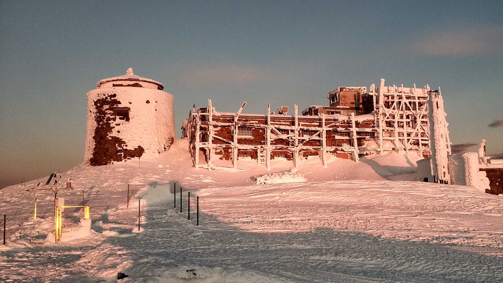
History and facilities

The station on Mount Pip Ivan Chornohirskyi is a former astronomical and meteorological observatory built at 2,028 meters above sea level in 1938. It was intended to be one of Europe's most modern high-altitude scientific institutions, conducting astronomical, meteorological, and geophysical observations. Due to its shape and colour, the observatory was also known as the "White Elephant". However, it operated for only a short time: in 1939, with the outbreak of World War II, the station was abandoned and gradually fell into ruin. Since 2012, its reconstruction has begun as a joint initiative of the Vasyl Stefanyk Precarpathian National University and the University of Warsaw. Today, a modern scientific and rescue centre is being established there, combining climate science, biology, astronomy, and mountain rescue training research. In 2023, the "Observatory" was equipped with a meteorological and environmental observation point (an automatic weather station, Vaisala Automatic Weather Station AWS310 with sensors for temperature, relative humidity and dew point, atmospheric pressure, precipitation, sunlight duration, wind speed and direction, and long- and short-wave radiation, etc. was installed).

General research and databases

Climate science, biology, ecology research and mountain rescue activities.

Station Monitoring

Human dimension

Distance to the nearest settlement: Dzembronya village - 10.5 km; Shybene village - 11 km. The station is located within the Carpathian National Nature Park.

Access

The best and safest period for access is from May to September.

Member of: