Address

Netherlands Arctic Station
P.O.Box 1
N-9173 Ny-Ålesund
Norway

Station manager

Maarten Loonen
E-mail: m.j.j.e.loonen@rug.nl

Contact Station


www.rug.nl/arcticcentre

Station Features

Opening year: 1995 Status: Open
  • Type of station: Station
  • Operational period – year-round or Month A to Month B: Mid June-mid August
  • Name of station owner: University of Groningen, Arctic Centre
  • Type of owner: Private
  • Name of managing institution: University of Groningen, Arctic Centre
  • Managing Institution Country: Netherlands
  • Station owner country: Netherlands
  • Partner institution: No
  • Station latitude: 78,92555556
  • Station longitude: 11,93472222
  • Country (station location): Svalbard and Jan Mayen Islands
  • Altitude of station: 5 m a.s.l
  • Min. altitude within study area: 0 m a.s.l
  • Max. altitude within study area: 556 m a.s.l
  • Nearest town/settlement: Longyearbyen (2116 inhabitants)
  • Distance to nearest town/settlement: 115 km
  • Number of residents in nearest town: 2116
  • Distance to nearest public transport facility (Airport, Ferry terminal, Train station, Bus station): 0 km
  • Maps available at station: 1:100 000
  • Climate zone: High Arctic
  • Period of measurments for climate data below [year to year]:
  • Mean annual temperature: -6,3 °C
  • Mean temperature in February: -14,6 °C
  • Mean temperature in July: 4,9 °C
  • Precipitation type: Snow, Rain
  • Sea ice break up: June
  • Lake ice break up: June, July
  • Dominant wind direction: Northwest
  • Mean annual wind speed: 4 m/s
  • Maximum wind speed (absolute): 21,6 m/s
  • Landscape features Mountains, Valleys, Lake, River, Sea
  • Permafrost zone Continuous
  • Snow and ice on land Ice Caps, Glaciers, Permanent snow patches
  • Vegetation zone Gramminoid tundra, Peatlands
  • Wildlife Bird colonies
  • Human use Settlement

Facilities

  • Area under roof: 114 m²
  • Max. number of visitors at a time : 7
  • Showers: No
  • Laundry facilities: No
  • Power supply – period (from ‘hour’ to ‘hour’ or 24 hours): 24 hours
  • Power supply - plug type C
  • Means of transportation to/from station Chartered plane/helicopter
  • Air transport landing facilities at station Helipad
  • Airstrip (Length × Width) : 800 × 50 m
  • Airstrip surface : Gravel/Sand
  • Transport on land - at station Other
  • Transport on water - at station Other
  • Water landing facilities Warf/pier
  • Number of staff peak season/summer: 1
  • Number of staff off season/winter: 0
  • Compulsory safety equipment VHF, Weapon/rifle, Other
  • Laboratory equipment Other
  • Laboratory area: 16 m²
  • Field to station VHF
  • Station to outside world Internet
  • IT Infrastructure Computers
  • Medical facilities: Yes
  • Medical capability Basic
  • Distance to hospital (estimated time – hours): 115

Science

  • Transnational Access: Yes
  • Remote Access: Yes
  • INTERACT Virtual Access: No
  • Permitting issues categories
    • Permits required for access to the station
    • Permits required for studies
  • Partner institutions (involved in the operation of the station)
    • Partner institution
  • Climate
    • Snow
    • Rain
    • Hail
  • Housing and accomodation
    • Showers
    • Laundry facilities
    • A
    • B
    • C
    • D
    • E
    • F
    • G
    • H
    • I
    • J
    • K
    • L
    • M
    • N
    • O
    • Municipal grid
    • Diesel/oil/gas
    • Wood
    • Solar
    • Wind
    • Water
    • Geothermal
    • Biofuel
    • Other
  • Logistics
    • Electrical and IT technologies
    • Mechanical
    • Metal
    • Wood
    • Plexiglas
    • Other
    • Walk
    • None
    • Tracked vehicle
    • Truck
    • SUV (4x4)
    • Car
    • Zodiac
    • ATV
    • Snowmobile
    • Open boat/Dhinghy
    • Closed boat
    • Bicycles
    • Amphibie vehicle
    • Ski
    • Other
    • Snow shoes
    • KickSledges
    • Other
    • Ski
    • Snowmobile
    • Boat
    • Car
    • Tracked vehicle
    • Truck
    • SUV (4x4)
    • Bus
    • Train
    • Airstrip
    • Scheduled flight
    • Chartered plane/helicopter
    • Helipad
    • None
    • Other
    • Harbour/port
    • Warf/pier
    • Pontoon/float bridge
    • Barges
    • Beach
  • Aircraft landing facilities
    • Helipad
  • Features in the facility area
    • Permanent snowpatches
    • Mountain
    • Valley
    • Lake
    • River
    • Shoreline
    • Tree line
    • Polar deserts/semi-deserts
    • Shrub tundra
    • Gramminoid tundra
    • Forest tundra
    • Peatlands
    • Wetlands
    • Palsa mires
    • Deciduous forest
    • Evergreen forest
    • Human settlements or resource use in the area
    • Arable land
    • Other
  • Main science disciplines
    • Astronomy
    • Atmospheric sciences
    • Cryology
    • Geology
    • Hydrology
    • Limnic biology
    • Marine biology
    • Terrestrial biology
    • Human biology
    • Anthropology
    • Archaeology
    • Sociology
    • Climate change
    • Environmental science (incl. pollution)
    • Oceanography
    • Agriculture
    • Animal husbandry
    • Fisheries
    • Forestry
    • Hunting
    • Tourism
  • Workshop facilities
    • Metal workshop
    • Wood workshop
    • Plexiglas workshop
    • Staff available to assist with constructions
  • Communication
    • Telephone
    • Satellite phone
    • VHF
    • E-mail
    • Internet
    • Computer
    • Printer
    • Scanner
    • Fax
  • Meteorology
    • Air temperature
    • Air humidity
    • Air pressure
    • Wind velocity
    • Wind direction
    • Precipitation
  • Vegetation
    • Flowering phenology
    • Amount of flowering
    • NDVI (plot/transect)
    • Landscape NDVI (from satellite images)
    • Vascular plant community composition
    • Bryophyte community composition
    • Lichen community composition
    • Fungi community composition
    • Berry production
    • Aerobiological monitoring (pollen, spores, etc.)
    • Species list (community composition)
  • Arthropods
    • Abundance
    • Emergence phenology
    • Insect herbivory
    • Species list (community composition)
  • Birds
    • Abundance
    • Distribution
    • Phenology
    • Breeding birds
    • Nest initiation phenology
    • Nest predation rates
    • Species list (community composition)
  • Mammals
    • Mammal abundance
    • Mammal distribution
    • Mammal reproduction
    • Mortality
    • Predation
    • Physiology
    • Species list (community composition)
  • Lake ecology
    • Phytoplankton (including chlorophyll)
    • Zooplankton
    • Vegetation
    • Fish
    • Invertebrates
    • Species list (community composition)
  • Pollution
    • Pollution measurements in vegetation
    • Pollution measurements in water
    • Pollution measurements in mammals (body burdens, biomarkers)
    • Pollution measurements in birds (body burdens, biomarkers on both adults and offspring e.g. egg shell thinning, macro plastic in nests/in body)
  • Diseases
    • Mammals
    • Birds
    • Fish
    • Vegetation
    • Other
  • Parasites
    • Mammals
    • Birds
    • Fish
    • Vegetation
    • Other
  • Landscape and environment
    • Mountains
    • Nunataks
    • Volcano/crater
    • Lava fields
    • Plateaus
    • Moraines
    • Valleys
    • Homothermic Springs
    • Lake
    • Thermokarst lake
    • River
    • Delta/estuarie
    • Fjord
    • Sea
    • Continuous
    • Discontinuous
    • Beach
    • Sporadic
    • Rocky shores
    • Pingos/ice lenses
    • Sea cliffs
    • Other (text)
    • Palsa mires
    • Ice Caps
    • None
    • Glaciers
    • Permanent snow patches
    • None
    • Tree line
    • Polar desert/Semi-desert
    • Gramminoid tundra
    • Shrub tundra
    • Forest tundra
    • Wetlands
    • Peatlands/mires
    • Salt marshes/lagoons
    • Heath
    • Grassland
    • Deciduous forest
    • Terrestrial carnivores
    • Evergreen forest
    • Alpine heath
    • Ungulates
    • Hares
    • Other (text)
    • Rodents
    • Bird colonies
    • Polar bear
    • Whales
    • Seals
    • Fish
    • Settlement
    • Fishing
    • Hunting
    • Forestry
    • Agriculture
    • Tourism
    • Animal husbandry
    • Leisure activities
  • Field equipment
    • PLB
    • VHF
    • HF
    • Satellite phone
    • Mobile phone
    • GPS
    • Weapon/rifle
    • Flare gun
    • Bearspray
    • PLB
    • First aid kit
    • Glacier rescue kit
    • VHF
    • Avalanche rescue kit
    • HF
    • Satellite phone
    • Overnight equipment
    • Other
    • Mobile phone
    • GPS
    • Weapon/rifle
    • Flare gun
    • Bearspray
    • PLB
    • First aid kit
    • Glacier rescue kit
    • VHF
    • Avalanche rescue kit
    • HF
    • Satellite phone
    • Overnight equipment
    • Other
    • Mobile phone
    • GPS
    • Weapon/rifle
    • Flare gun
    • Bearspray
    • Tent
    • First aid kit
    • Glacier rescue kit
    • Sleeping matress
    • Avalanche rescue kit
    • Sleeping bag
    • Cooking equipment and utensils
    • Overnight equipment
    • Other
    • Gas/alcohol for cooking
    • Field power supply available at station
  • Laboratory
    • Freezer < -80
    • Freezer -40 - -10
    • Fridge
    • Microscopes
    • Basic laboratory equipment
    • Advanced laboratory equipment
    • Basic chemical reagents
    • Analytical instrumentation
    • Other
    • Laboratory available in nearby town/settlement
  • Communication and IT
    • Mobile phone
    • VHF
    • Satellite phone
    • Other
    • Satellite phone
    • Mobile phone
    • Internet
    • Other
    • Wireless transfer of data from field site to station
    • Wifi
    • Computers
    • Printer
    • Data storage
    • Statistical tools
    • GIS tools
    • Other
  • Medical facilities
    • Medical facilities
    • Basic
    • Medium
    • Extensive
    • Dental
    • Surgery
    • Other
    • No
    • In peak season
    • When open

Station name and owner

The Netherlands’ Arctic Station is owned and run by the Arctic Centre of the University of Groningen.

Location

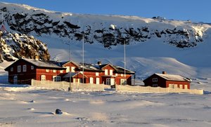
The Netherlands’ Arctic Station is situated in Kongsfjorden on the island of Spitsbergen and is part of an international research community in the former mining town of Ny-Ålesund, Svalbard. In this town, more than 10 nations have their own station while using shared facilities for meals and recreation. The whole local community is focussed on science and maintenance of infrastructure. Several stations have independent terrestrial research programmes and the Netherlands’ Arctic Station is the smallest of all.

Climate data

Grey colours are WMO Climate Normals including maximum and minimum values. Blue colours are individual years.

Climate data for the stations where extracted via Copernicus Climate Data Store, from the global gridded reanalysis product: ERA5 monthly averaged data on single levels from 1940 to present. Description and source code: Roemer J.K. 2023. https://doi.org/10.5281/zenodo.10214922 Data Source: Hersbach et al. 2023. Copernicus Climate Change Service (C3S) Climate Data Store (CDS), https://doi.org/10.24381/cds.f17050d7

Biodiversity and natural environment

Kongsfjorden is a beautiful high arctic environment with several glaciers terminating in the fjord. The raised beach terraces are sparsely vegetated with dense moss cover around small tundra lakes and below bird cliffs. Locally there are clear traces of former human activity by trappers and from coal mining. At present, the whole area is well-protected and a special permission is needed to enter the islands during the bird breeding season. In 1978, reindeer was re-introduced and since 1982 barnacle geese have established a colony and are regularly feeding between the houses. Both herbivores have a clear impact on the vegetation.

History and facilities

From 1916 to 1968, the village of Ny-Ålesund was a coal mining settlement. This village has now developed into a unique mix of stations, laboratories, and research infrastructure. There is a small international community of 25 to 180 people – all temporal residents. Tourists are discouraged to stay overnight. In 1990, the University of Groningen initiated a project on barnacle geese and later joined the shared facilities with the establishment of Nether­lands’ Arctic Station. The station consists of two small buildings for lodging with electricity but no plumbing. Shared facilities in town offer unique high-standard science and logistic support. There is a developing cooperation with the local German/French base AWIPEV.

General research and databases

Research focusses on the role of barnacle geese in the arctic ecosystem. Nutrient cycles, plant productivity, and vegetation patterns are studied to understand plant-herbivore interactions. Behaviour, timing, and breeding success of individually ringed geese are observed over their lifetime, and the effect of predators is studied as a dynamic interaction. Population trends of plants, herbivores, and predators are monitored in a warming environment. Long term experiments include grazing exclosures and greenhouses on paired vegetation plots. There are also projects focussing on the history of human exploitation and the effect of tourism on cultural heritage.

Station Monitoring

Human dimension

The local community in Ny-Ålesund is a mixture of nationalities from the various stations. The area is owned by a company called Kings Bay, taking care of the logistics for the entire village. Ny-Ålesund has no permanent residents and all activity is linked to science. The closest town is the Norwegian village of Longyearbyen, which is the main hub of Svalbard. In Longyearbyen, permanent residents are few (c. 2100). There are no indigenous people and most inhabitants originate from the Norwegian mainland and live on Svalbard only because of their temporal job assignment. Tourism, local administration, science, and coal mining are the most important sources of income.

Access

Throughout the year, Kings Bay organises two flights per week with a small plane (14 passengers) between Longyearbyen and Ny-Ålesund. In summer, there are about 30000 tourists landing by boat for just a few hours. There is only a limited amount of roads near the village. Local transportation is possible by car, bicycle, snowmobile, or foot. Small boats are used for transportation inside the fjord.

Member of: