Address

CNR Arctic Station 'Dirigibile Italia'
9173 Ny-Ålesund
Svalbard

Station manager

Mauro Mazzola
E-mail: mauro.mazzola@cnr.it

Contact Station

Phone: +39 06 499372331 – 332
E-mail: luigipaolo.dacqui@cnr.it

http://www.isp.cnr.it/index.php/en/

Station Features

Opening year: 1997 Status: Open
  • Type of station: Station
  • Operational period – year-round or Month A to Month B: March-October
  • Name of station owner: National Research Council
  • Type of owner: Government
  • Name of managing institution: Department of Earth System Science and Environmental ­Technologies (CNR-DTA)
  • Managing Institution Country: Italy
  • Station owner country: Italy
  • Partner institution: No
  • Station latitude: 78,92353611
  • Station longitude: 11,92590833
  • Country (station location): Svalbard and Jan Mayen Islands
  • Altitude of station: 10 m a.s.l
  • Min. altitude within study area: 0 m a.s.l
  • Max. altitude within study area: 556 m a.s.l
  • Nearest town/settlement: Longyearbyen (2116 inhabitants)
  • Distance to nearest town/settlement: 100 km
  • Number of residents in nearest town: 2116
  • Distance to nearest public transport facility (Airport, Ferry terminal, Train station, Bus station): 0 km
  • Distance to nearest research station: 0 km
  • Maps available at station: Map (1:100 000), aerial image
  • Climate zone: High Arctic
  • Period of measurments for climate data below [year to year]: Since 1974
  • Mean annual temperature: -6,3 °C
  • Mean temperature in February: -14,6 °C
  • Mean temperature in July: 4,9 °C
  • Precipitation type: Snow, Rain
  • Sea ice break up: January
  • Dominant wind direction: East
  • Mean annual wind speed: 0 m/s
  • Maximum wind speed (absolute): 0 m/s
  • Landscape features Valleys, Lake, River, Sea
  • Permafrost zone Continuous
  • Snow and ice on land Ice Caps, Glaciers
  • Vegetation zone Polar desert/Semi-desert, Gramminoid tundra, Peatlands
  • Human use Settlement

Facilities

  • Area under roof: 330 m²
  • Max. number of visitors at a time : 6
  • Showers: Yes
  • Laundry facilities: Yes
  • Power supply – period (from ‘hour’ to ‘hour’ or 24 hours): 24
  • Logistics area: 10 m²
  • Workshops Metal, Wood
  • Means of transportation to/from station Boat, Chartered plane/helicopter
  • Air transport landing facilities at station Airstrip, Helipad
  • Airstrip (Length × Width) : 800 × 60 m operated by King’s Bay AS
  • Airstrip surface : Gravel/Sand
  • Transport on land - at station Snowmobile, Other
  • Transport on water - at station Zodiac, Other
  • Water landing facilities Warf/pier
  • Number of staff peak season/summer: 1
  • Number of staff off season/winter: 1
  • Laboratory area: 160 m²
  • Laboratory equipment Freezer -40 - -10, Fridge, Other
  • Field to station VHF, Satellite phone, Other
  • Station to outside world Internet, Other
  • Medical facilities: Yes
  • Medical capability Basic
  • Staff with medical training/doctor When open
  • Distance to hospital (estimated time – hours): 115

Science

  • Transnational Access: Yes
  • Remote Access: Yes
  • INTERACT Virtual Access: Yes
  • Permitting issues categories
    • Permits required for access to the station
    • Permits required for studies
  • Partner institutions (involved in the operation of the station)
    • Partner institution
  • Climate
    • Snow
    • Rain
    • Hail
  • Housing and accomodation
    • Showers
    • Laundry facilities
    • A
    • B
    • C
    • D
    • E
    • F
    • G
    • H
    • I
    • J
    • K
    • L
    • M
    • N
    • O
    • Municipal grid
    • Diesel/oil/gas
    • Wood
    • Solar
    • Wind
    • Water
    • Geothermal
    • Biofuel
    • Other
  • Logistics
    • Electrical and IT technologies
    • Mechanical
    • Metal
    • Wood
    • Plexiglas
    • Other
    • Walk
    • None
    • Tracked vehicle
    • Truck
    • SUV (4x4)
    • Car
    • Zodiac
    • ATV
    • Snowmobile
    • Open boat/Dhinghy
    • Closed boat
    • Bicycles
    • Amphibie vehicle
    • Ski
    • Other
    • Snow shoes
    • KickSledges
    • Other
    • Ski
    • Snowmobile
    • Boat
    • Car
    • Tracked vehicle
    • Truck
    • SUV (4x4)
    • Bus
    • Train
    • Airstrip
    • Scheduled flight
    • Chartered plane/helicopter
    • Helipad
    • None
    • Other
    • Harbour/port
    • Warf/pier
    • Pontoon/float bridge
    • Barges
    • Beach
  • Aircraft landing facilities
    • Helipad
  • Features in the facility area
    • Permanent snowpatches
    • Mountain
    • Valley
    • Lake
    • River
    • Shoreline
    • Tree line
    • Polar deserts/semi-deserts
    • Shrub tundra
    • Gramminoid tundra
    • Forest tundra
    • Peatlands
    • Wetlands
    • Palsa mires
    • Deciduous forest
    • Evergreen forest
    • Human settlements or resource use in the area
    • Arable land
    • Other
  • Main science disciplines
    • Astronomy
    • Atmospheric sciences
    • Cryology
    • Geology
    • Hydrology
    • Limnic biology
    • Marine biology
    • Terrestrial biology
    • Human biology
    • Anthropology
    • Archaeology
    • Sociology
    • Climate change
    • Environmental science (incl. pollution)
    • Oceanography
    • Agriculture
    • Animal husbandry
    • Fisheries
    • Forestry
    • Hunting
    • Tourism
  • Workshop facilities
    • Metal workshop
    • Wood workshop
    • Plexiglas workshop
    • Staff available to assist with constructions
  • Communication
    • Telephone
    • Satellite phone
    • VHF
    • E-mail
    • Internet
    • Computer
    • Printer
    • Scanner
    • Fax
  • Meteorology
    • Air temperature
    • Air humidity
    • Air pressure
    • Wind velocity
    • Wind direction
    • Precipitation
  • Energy balance and radiation
    • Energy balance
    • Short wave incoming
    • Short wave outgoing
    • Long wave incoming
    • Long wave outgoing
    • Net radiation
    • UV-B
    • Multi-spectral
    • Cloud cover/hours of sunshine
  • Geology/Geomorphology
    • Quaternary geology
    • Sedimentology
    • Bedrock geology
    • Erosion
  • Geophysics and Geodesy
    • Gravity
    • Magnetic field
    • Aurora
    • Seismic activity
  • Sub-surface characteristics
    • Ground surface temperature
    • Soil temperature
    • Soil moisture
    • Ground water table
    • Soil water chemistry
    • Active layer depth
    • Permafrost distribution
    • Permafrost thickness
    • Permafrost temperature
  • Snow characteristics
    • Snow depth
    • Snow cover
    • Snow density
    • Snow temperature
  • Greenhouse gas exchange
    • CO<sub>2</sub> exchange
    • CH<sub>4</sub> exchange
    • N<sub>2</sub>O exchange
  • Pollution
    • In air
    • In water
    • In soil
    • In snow/ice
    • Contaminants in species
  • Mass balace
    • Mass balance
    • Snow water equivalent
    • Snowcover stratigraphy
    • Equilibrium Line Altitude
    • Duration of snow cover
    • Calving flux
  • Isotope chemistry of snow, ice and water
    • Isotope chemistry of snow, ice and water
  • Bio-geochemistry of snow, ice and water
    • Biogeochemistry of snow, ice and water  
  • Pollutants e.g. POPs and heavy metals in snow, ice and water
    • Pollutants e.g. POPs and heavy metals, in snow, ice and water
  • Landscape and environment
    • Mountains
    • Nunataks
    • Volcano/crater
    • Lava fields
    • Plateaus
    • Moraines
    • Valleys
    • Homothermic Springs
    • Lake
    • Thermokarst lake
    • River
    • Delta/estuarie
    • Fjord
    • Continuous
    • Sea
    • Discontinuous
    • Beach
    • Sporadic
    • Rocky shores
    • Pingos/ice lenses
    • Sea cliffs
    • Other (text)
    • Palsa mires
    • Ice Caps
    • None
    • Glaciers
    • Permanent snow patches
    • None
    • Tree line
    • Polar desert/Semi-desert
    • Gramminoid tundra
    • Shrub tundra
    • Forest tundra
    • Wetlands
    • Peatlands/mires
    • Salt marshes/lagoons
    • Heath
    • Grassland
    • Deciduous forest
    • Evergreen forest
    • Terrestrial carnivores
    • Alpine heath
    • Ungulates
    • Hares
    • Other (text)
    • Rodents
    • Bird colonies
    • Polar bear
    • Whales
    • Seals
    • Fish
    • Settlement
    • Fishing
    • Hunting
    • Forestry
    • Agriculture
    • Tourism
    • Animal husbandry
    • Leisure activities
  • Laboratory
    • Freezer < -80
    • Freezer -40 - -10
    • Fridge
    • Microscopes
    • Basic laboratory equipment
    • Advanced laboratory equipment
    • Basic chemical reagents
    • Analytical instrumentation
    • Other
    • Laboratory available in nearby town/settlement
  • Communication and IT
    • Mobile phone
    • VHF
    • Satellite phone
    • Other
    • Satellite phone
    • Mobile phone
    • Internet
    • Other
    • Wireless transfer of data from field site to station
    • Wifi
    • Computers
    • Printer
    • Data storage
    • Statistical tools
    • GIS tools
    • Other
  • Medical facilities
    • Medical facilities
    • Basic
    • Medium
    • Extensive
    • Dental
    • Surgery
    • Other
    • No
    • In peak season
    • When open

Station name and owner

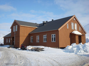
CNR Arctic Station “Dirigibile Italia” is the Italian scientific station in Svalbard. It is funded and managed by the National Research Council of Italy (CNR).

Location

<p>The station is located in Ny-&Aring;lesund, on the shores of Kongs&shy;fjorden, on the west coast of Spitzbergen, the largest island of the Svalbard archipelago. Ny-&Aring;lesund was a mining village until 1963. During the 1990&rsquo;s it transformed into a multidisciplinary science settlement, and today stations from 10 different nations host researchers from up to 20 different countries. The area around the village is geographically diverse, including the fjord with several islands, a plateau, alluvial plains, mountains with large glaciers and extensive moraine systems, glacial rivers, coastal lagoons, and a small lake. The area further includes ornithological reserves and a nature reserve with regulated access.</p>

Climate data

Grey colours are WMO Climate Normals including maximum and minimum values. Blue colours are individual years.

Climate data for the stations where extracted via Copernicus Climate Data Store, from the global gridded reanalysis product: ERA5 monthly averaged data on single levels from 1940 to present. Description and source code: Roemer J.K. 2023. https://doi.org/10.5281/zenodo.10214922 Data Source: Hersbach et al. 2023. Copernicus Climate Change Service (C3S) Climate Data Store (CDS), https://doi.org/10.24381/cds.f17050d7

Biodiversity and natural environment

Ny-Ålesund enjoys the mildest climate at this latitude due to a distant branch of the Gulf Stream bordering the west coast of Spitzbergen. The fauna is dominated by a large variety of birds, including arctic terns, auks, kittiwakes, gulls, barnacle geese, northern fulmars, Svalbard ptarmigans, and Arctic skuas. Mammals include Svalbard reindeer, arctic foxes, and a sporadic presence of polar bears, also seals and less frequently whales, are spotted in the fjord. The permafrost is continuous and 75-450 m thick, and the active layer thickness ranges between 0.3 and 3.8 m. The whole area lies within the Dryas octopetala zone of the high-arctic fell-field vegetation.

History and facilities

The Station was established in 1997. It provides accommodation for seven persons in single and double rooms. Also, laboratories with basic equipment are available at the station. A 32 m high ‘Admundsen-Nobile Climate Change Tower’ belongs to the station, and is equipped with instruments investigating energy budget and flux exchanges at the atmosphere-land interface. In addition, the ‘Gruvebadet Laboratory’ for sampling aerial pollutants and particles is part of the station’s facilities. The station has a membership in the Ny-Ålesund Marine Laboratory consortium, an experimental laboratory for research in marine ecology, physiology, and biochemistry.

General research and databases

Research programmes currently developed at the station deals with microbial ecology and evolution; biogeochemistry and energy fluxes; vegetation and permafrost studies; oceanography, marine biomarkers; atmosphere, aerosols, gases and clouds; remote sensing of the environment; sun-earth relations and space weather; human biology and medicine.

Link to data: https://dataportal.eu-interact.org/stations

Station Monitoring

Human dimension

11 permanent stations are established in Ny-Ålesund by 10 different countries and the entire settlement is owned and operated by the Norwegian State owned company King’s Bay AS. Researchers from many countries regularly come to Ny-Ålesund to work. King’s Bay AS provides and manages all necessary infrastructures and services in the community including meals, maintenance of buildings and roads, post office, local shop, airport, and harbour. Research is coordinated by the Ny-Ålesund Science Managers Committee (NySMAC) and the Svalbard Science Forum (SSF).

Access

Regular flights between Ny-Ålesund and Longyearbyen take place four times per week in summer and twice per week in winter. There is an international airport in Longyearbyen with scheduled connections to mainland Norway. Ny-Ålesund can be reached also by boat. Sailing in the fjord is possible for people at the station through agreements with the Sverdrup Station of the Norwegian Polar Institute and with King’s Bay AS. In winter and spring snowmobiles are available for field trips. In summer, hiking is the only mean of transport in the field outside the village.

Member of: