Address

NIBIO Svanhovd
23 Svanhovd,
NO-9925 Svanvik
Norway

Station manager

Snorre Hagen
E-mail: snorre.Hagen@nibio.no

Contact Station

E-mail: cornelya.klutsch@nibio.no

www.bioforsk.no/svanhovd

Station Features

Opening year: 1934 Status: Open
  • Type of station: Station
  • Operational period – year-round or Month A to Month B: Year-round
  • Name of station owner: Norwegian Institute of Bioeconomy Research (NIBIO)
  • Type of owner: Government
  • Name of managing institution: Norwegian Institute of Bioeconomy Research (NIBIO)
  • Managing Institution Country: Norway
  • Station owner country: Norway
  • Partner institution: No
  • Station latitude: 69,45395556
  • Station longitude: 30,04180833
  • Country (station location): Norway
  • Altitude of station: 35 m a.s.l
  • Min. altitude within study area: 0 m a.s.l
  • Max. altitude within study area: 250 m a.s.l
  • Nearest town/settlement: Kirkenes/Svanik (3400/800 inhabitants)
  • Distance to nearest town/settlement: 0 km
  • Number of residents in nearest town: 3400
  • Distance to nearest public transport facility (Airport, Ferry terminal, Train station, Bus station): 40 km
  • Distance to nearest research station: 800 km
  • Maps available at station: Maps (1:10 000, 1:50 000, 1:5000)
  • Climate zone: Sub-Arctic
  • Period of measurments for climate data below [year to year]:
  • Mean annual temperature: -0,6 °C
  • Mean temperature in February: -13 °C
  • Mean temperature in July: 14 °C
  • Precipitation type: Snow, Rain
  • Sea ice break up: January
  • Lake ice break up: May, June, July
  • River ice break up: May, June, July
  • Dominant wind direction: Southwest
  • Mean annual wind speed: 1,5 m/s
  • Maximum wind speed (absolute): 14,5 m/s
  • Landscape features Mountains, Valleys, Lake, River, Sea
  • Snow and ice on land None
  • Vegetation zone Tree line, Peatlands, Wetlands, Peatlands/mires, Deciduous forest, Evergreen forest
  • Human use Settlement

Facilities

  • Area under roof: 0 m²
  • Max. number of visitors at a time : 80
  • Showers: Yes
  • Laundry facilities: Yes
  • Power supply - plug type C, F
  • Power sources at station Municipal grid
  • Logistics area: 50 m²
  • Conference room capacity: 70
  • Workshops Metal, Wood
  • Means of transportation to/from station Car, Bus, Other
  • Air transport landing facilities at station None
  • Airstrip (Length × Width) : 1755 m (length) Kirkenes Airport
  • Transport on water - at station Open boat/Dhinghy
  • Water landing facilities Beach
  • Number of staff peak season/summer: 30
  • Number of staff off season/winter: 25
  • Staff able to assist (fieldwork): Yes - if time allows
  • Staff able to assist (workshops): Yes - if time allows
  • Compulsory safety equipment Mobile phone, GPS
  • Safety equipment available at station Mobile phone, GPS, Flare gun, Bearspray, First aid kit
  • Field instruments available at station: Microbiological, chemical-physical and DNA-analysis (brown bear), simple field labs, weather and radioactivity station
  • Field to station Mobile phone
  • Station to outside world Mobile phone, Internet
  • IT Infrastructure Computers, Printer
  • Medical facilities: Yes
  • Medical capability Basic
  • Distance to hospital (estimated time – hours): 1
  • Laboratory area: 100 m²
  • Laboratory equipment Freezer < -80, Freezer -40 - -10, Fridge, Microscopes, Basic laboratory equipment, Advanced laboratory equipment, Basic chemical reagents

Science

  • Transnational Access: Yes
  • Remote Access: Yes
  • INTERACT Virtual Access: Yes
  • Permitting issues categories
    • Permits required for access to the station
    • Permits required for studies
  • Partner institutions (involved in the operation of the station)
    • Partner institution
  • Climate
    • Snow
    • Rain
    • Hail
  • Housing and accomodation
    • Showers
    • Laundry facilities
    • A
    • B
    • C
    • D
    • E
    • F
    • G
    • H
    • I
    • J
    • K
    • L
    • M
    • N
    • Municipal grid
    • O
    • Diesel/oil/gas
    • Wood
    • Solar
    • Wind
    • Water
    • Geothermal
    • Biofuel
    • Other
  • Logistics
    • Electrical and IT technologies
    • Mechanical
    • Metal
    • Wood
    • Plexiglas
    • Other
    • Walk
    • None
    • Tracked vehicle
    • Truck
    • SUV (4x4)
    • Car
    • Zodiac
    • ATV
    • Open boat/Dhinghy
    • Snowmobile
    • Closed boat
    • Bicycles
    • Amphibie vehicle
    • Ski
    • Other
    • Snow shoes
    • KickSledges
    • Other
    • Ski
    • Snowmobile
    • Boat
    • Car
    • Tracked vehicle
    • Truck
    • SUV (4x4)
    • Bus
    • Train
    • Airstrip
    • Scheduled flight
    • Chartered plane/helicopter
    • Helipad
    • Other
    • None
    • Harbour/port
    • Warf/pier
    • Pontoon/float bridge
    • Barges
    • Beach
  • Aircraft landing facilities
    • Helipad
  • Features in the facility area
    • Permanent snowpatches
    • Mountain
    • Valley
    • Lake
    • River
    • Shoreline
    • Tree line
    • Polar deserts/semi-deserts
    • Shrub tundra
    • Gramminoid tundra
    • Forest tundra
    • Peatlands
    • Wetlands
    • Palsa mires
    • Deciduous forest
    • Evergreen forest
    • Human settlements or resource use in the area
    • Arable land
    • Other
  • Main science disciplines
    • Astronomy
    • Atmospheric sciences
    • Cryology
    • Geology
    • Hydrology
    • Limnic biology
    • Marine biology
    • Terrestrial biology
    • Human biology
    • Anthropology
    • Archaeology
    • Sociology
    • Climate change
    • Environmental science (incl. pollution)
    • Oceanography
    • Agriculture
    • Animal husbandry
    • Fisheries
    • Forestry
    • Hunting
    • Tourism
  • Workshop facilities
    • Metal workshop
    • Wood workshop
    • Plexiglas workshop
    • Staff available to assist with constructions
  • Communication
    • Telephone
    • Satellite phone
    • VHF
    • E-mail
    • Internet
    • Computer
    • Printer
    • Scanner
    • Fax
  • Landscape and environment
    • Mountains
    • Nunataks
    • Volcano/crater
    • Lava fields
    • Plateaus
    • Moraines
    • Valleys
    • Homothermic Springs
    • Lake
    • Thermokarst lake
    • River
    • Delta/estuarie
    • Fjord
    • Sea
    • Continuous
    • Discontinuous
    • Beach
    • Sporadic
    • Rocky shores
    • Pingos/ice lenses
    • Sea cliffs
    • Other (text)
    • Palsa mires
    • Ice Caps
    • None
    • Glaciers
    • Permanent snow patches
    • None
    • Tree line
    • Polar desert/Semi-desert
    • Gramminoid tundra
    • Shrub tundra
    • Forest tundra
    • Wetlands
    • Peatlands/mires
    • Salt marshes/lagoons
    • Heath
    • Grassland
    • Deciduous forest
    • Evergreen forest
    • Terrestrial carnivores
    • Alpine heath
    • Ungulates
    • Hares
    • Other (text)
    • Rodents
    • Bird colonies
    • Polar bear
    • Whales
    • Seals
    • Fish
    • Settlement
    • Fishing
    • Hunting
    • Forestry
    • Agriculture
    • Tourism
    • Animal husbandry
    • Leisure activities
  • Field equipment
    • PLB
    • VHF
    • HF
    • Satellite phone
    • Mobile phone
    • GPS
    • Weapon/rifle
    • Flare gun
    • Bearspray
    • PLB
    • First aid kit
    • Glacier rescue kit
    • VHF
    • Avalanche rescue kit
    • HF
    • Satellite phone
    • Overnight equipment
    • Other
    • Mobile phone
    • GPS
    • Weapon/rifle
    • Flare gun
    • Bearspray
    • PLB
    • First aid kit
    • Glacier rescue kit
    • VHF
    • Avalanche rescue kit
    • HF
    • Satellite phone
    • Overnight equipment
    • Mobile phone
    • Other
    • GPS
    • Weapon/rifle
    • Flare gun
    • Bearspray
    • First aid kit
    • Tent
    • Glacier rescue kit
    • Sleeping matress
    • Avalanche rescue kit
    • Sleeping bag
    • Cooking equipment and utensils
    • Overnight equipment
    • Other
    • Gas/alcohol for cooking
    • Field power supply available at station
  • Communication and IT
    • Mobile phone
    • VHF
    • Satellite phone
    • Other
    • Satellite phone
    • Mobile phone
    • Internet
    • Other
    • Wireless transfer of data from field site to station
    • Wifi
    • Computers
    • Printer
    • Data storage
    • Statistical tools
    • GIS tools
    • Other
  • Medical facilities
    • Medical facilities
    • Basic
    • Medium
    • Extensive
    • Dental
    • Surgery
    • Other
    • No
    • In peak season
    • When open
  • Laboratory
    • Freezer < -80
    • Freezer -40 - -10
    • Fridge
    • Microscopes
    • Basic laboratory equipment
    • Advanced laboratory equipment
    • Basic chemical reagents
    • Analytical instrumentation
    • Other
    • Laboratory available in nearby town/settlement

Station name and owner

The Nibio Svanhovd Research Station belongs to the Norwegian Institute for Agricultural and Environmental Research (Bioforsk).

Location

Nibio Svanhovd is located in the Pasvik area in NE Norway (69°27’ N, 30°03’ E), approximately 40 km south of the fjords of the Barents Sea, 400 km north of the Arctic Circle, and in close vicinity to Russia and Finland. Nibio Svanhovd is situated in Svanvik, a small village in the Pasvik Valley. It is located at the western shore of the Pasvik River that originates from the huge Lake Inari in Finland and flows northwards into the Barents Sea and defines the border between Norway and Russia.

Climate data

Grey colours are WMO Climate Normals including maximum and minimum values. Blue colours are individual years.

Climate data for the stations where extracted via Copernicus Climate Data Store, from the global gridded reanalysis product: ERA5 monthly averaged data on single levels from 1940 to present. Description and source code: Roemer J.K. 2023. https://doi.org/10.5281/zenodo.10214922 Data Source: Hersbach et al. 2023. Copernicus Climate Change Service (C3S) Climate Data Store (CDS), https://doi.org/10.24381/cds.f17050d7

Biodiversity and natural environment

The surroundings in the Pasvik Valley are part of the western distribution limit of the Russian taiga and the fauna and flora has a strong eastern influence, with many species not found in other areas of Europe, e.g. interesting aquatic flora. The area includes old-growth pine forest, wetlands, lakes, rivers, mountain birch forest, tundra, seashore, and fjords. Most groups of organisms in the area are poorly studied with many still unknown species in certain taxa. The area is also found to be the northernmost distribution of several species and the Pasvik River has a very high biological diversity compared to other rivers in Norway. The area is exposed to several invading species.

History and facilities

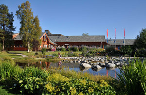
Svanhovd was established in 1934 as a governmental demonstration farm to provide expertise and aid to the settlers of the Pasvik Valley. In the early 1990s, a change of activity towards environmental research was motivated in particular due to large emissions from the metal smelters in the Russian city Nikel (9 km away from Svanhovd). 2001, a visitor centre for the Øvre Pasvik National Park was established and, in 2006, Svanhovd Environmental Centre became a part of the Norwegian Institute for Agricultural and Environmental Research. The laboratory at Bioforsk Svanhovd has facilities for microbiological, chemical-physical, and DNA-analysis. It is accredited for DNA analyses of brown bears. Bioforsk Svanhovd has a conference centre with accommodation for 50 persons (in single and double rooms, with private bathrooms). Guests are free to use Svanhovds fireplace, TV lounge, sauna, and laundry room. The conference centre offers an auditorium for 80 persons, and smaller meeting rooms for 5 to 30 persons. Additional accommodation can be arranged in Svanvik (walking distance) and at hotels in Kirkenes (45 minutes by car).

General research and databases

The region offers ‘round-the-corner ecological laboratories’ for several important research areas: Pristine nature in subarctic ecosystems, changes in land use (farming and abandoned land), climatic and environmental gradients, etc. Bioforsk Svanhovd works with issues related to natural resources, protected areas, biological diversity, and environmental research in the Barents Region. Some work on agricultural issues is also carried out. Each year, surveys within the national brown-bear monitoring programme in Norway, Finland, Sweden, and Russia is carried out.

Link to data: https://dataportal.eu-interact.org/stations

Station Monitoring

Human dimension

The Pasvik Valley offers nature tourism, fishing, bird-watching, hunting, forestry, northern agriculture, reindeer husbandry, mining, and research. Kirkenes (c. 3400 inhabitants), that is located 40 km NW of Svanhovd, was established in late nineteenth century as a port town for the mining industry at Bjørnevatn a few km away and for forestry. The area has been inhabited by Sami people for several centuries.

Access

Svanhovd is an excellent meeting point for researchers and visitors from all over the world, situated in NE Norway in close vicinity to Russia, Finland, and Sweden, and with the facilities offered by Svanhovd Conference Centre. The Botanical Garden at Svanhovd demonstrates the diversity of plants and trees in the Pasvik Valley. It is easy to come to Svanhovd, with daily flights from Oslo Gardermoen Airport to Kirkenes Airport (Høybuktmoen), with about 2 hours flight time (SAS and Norwegian), and then 45 minutes (40 km) by car to Svanhovd (Road 885). Taxi or rental cars are available at Kirkenes Airport.

Member of: