Address

Delivery address summer:
Tarfala forskningsstation
c/o Kallax Flyg AB
Nikkaluokta flygbas
SE 98199 Nikkaluokta
+46(0)980-81000

Shipping address winter:
Tarfala forskningsstation
c/o Nikkaluokta Sarri AB
attn. Erik Sarri
Nikkaluokta 1104
SE 981 99 Nikkaluokta
+46(0)980-55015

Station manager

TRS Director: Nina Kirchner, +46 (0)70-60 90 588; TRS Station manager: Annika Granebeck, +46 (0) 72-148 91 49
E-mail: nina.kirchner@natgeo.su.se

Contact Station

Phone: +46 (0)72 715 50 39
E-mail: tarfala@natgeo.su.se

https://www.su.se/tarfala-research-station/

Station Features

Opening year: 1946 Status: Open
  • Type of station: Station
  • Operational period – year-round or Month A to Month B: Mid March to end of April, and end of June to late September.
  • Name of station owner: Statens Fastighetsverk
  • Type of owner: Government
  • Name of managing institution: Stockholm University
  • Managing Institution Country: Sweden
  • Station owner country: Sweden
  • Partner institution: No
  • Station latitude: 67,91102058
  • Station longitude: 18,61079381
  • Country (station location): Sweden
  • Altitude of station: 1130 m a.s.l
  • Min. altitude within study area: 0 m a.s.l
  • Max. altitude within study area: 2097 m a.s.l
  • Nearest town/settlement: Nikkaluokta
  • Distance to nearest town/settlement: 27 km
  • Distance to nearest public transport facility (Airport, Ferry terminal, Train station, Bus station): 87 km
  • Maps available at station: Tarfala valley (1:20 000) , Glacier maps (1:10 000) ; aerial image; satellite image; Google Earth
  • Type of surface facility is built on: Rock
  • Climate zone: Sub-Arctic
  • Period of measurments for climate data below [year to year]: 1965-2011
  • Mean annual temperature: -3,3 °C
  • Mean temperature in February: -10,9 °C
  • Mean temperature in July: 7,4 °C
  • Precipitation type: Snow, Rain
  • Lake ice break up: August
  • River ice break up: August
  • Dominant wind direction: North
  • Mean annual wind speed: 3 m/s
  • Maximum wind speed (absolute): 81 m/s
  • Landscape features Mountains, Valleys, Lake, River, Sea
  • Permafrost zone Discontinuous
  • Snow and ice on land Ice Caps, Glaciers, Permanent snow patches
  • Vegetation zone Tree line, Gramminoid tundra
  • Human use Settlement

Facilities

  • Area under roof: 500 m²
  • Max. number of visitors at a time : 28
  • Showers: Yes
  • Laundry facilities: Yes
  • Power supply – period (from ‘hour’ to ‘hour’ or 24 hours): 24 h
  • Logistics area: 100 m²
  • Workshops Metal, Plexiglas, Wood
  • Means of transportation to/from station Walk, Ski, Other
  • Air transport landing facilities at station Helipad
  • Airstrip (Length × Width) :
  • Transport on land - at station Snowmobile
  • Number of staff peak season/summer: 8
  • Number of staff off season/winter: 8
  • Staff able to assist (fieldwork): Yes - if time allows
  • Staff able to assist (workshops): Yes - if time allows
  • Compulsory safety equipment PLB, VHF, GPS, Glacier rescue kit, Avalanche rescue kit
  • Laboratory area: 40 m²
  • Field to station Mobile phone, VHF, Satellite phone, Other
  • Station to outside world Mobile phone, Internet, Other
  • IT Infrastructure Computers, Printer
  • Medical facilities: Yes
  • Staff with medical training/doctor In peak season
  • Distance to hospital (estimated time – hours): 90

Science

  • Transnational Access: Yes
  • Remote Access: Yes
  • INTERACT Virtual Access: Yes
  • Permitting issues categories
    • Permits required for access to the station
    • Permits required for studies
  • Partner institutions (involved in the operation of the station)
    • Partner institution
  • Climate
    • Snow
    • Rain
    • Hail
  • Housing and accomodation
    • Showers
    • Laundry facilities
    • A
    • B
    • C
    • D
    • E
    • F
    • G
    • H
    • I
    • J
    • K
    • L
    • M
    • N
    • O
    • Municipal grid
    • Diesel/oil/gas
    • Wood
    • Solar
    • Wind
    • Water
    • Geothermal
    • Biofuel
    • Other
  • Logistics
    • Electrical and IT technologies
    • Mechanical
    • Metal
    • Wood
    • Plexiglas
    • Other
    • Walk
    • None
    • Tracked vehicle
    • Truck
    • SUV (4x4)
    • Car
    • ATV
    • Zodiac
    • Snowmobile
    • Open boat/Dhinghy
    • Closed boat
    • Bicycles
    • Amphibie vehicle
    • Ski
    • Other
    • Snow shoes
    • KickSledges
    • Other
    • Ski
    • Snowmobile
    • Boat
    • Car
    • Tracked vehicle
    • Truck
    • SUV (4x4)
    • Bus
    • Train
    • Airstrip
    • Scheduled flight
    • Helipad
    • Chartered plane/helicopter
    • Other
    • None
    • Harbour/port
    • Warf/pier
    • Pontoon/float bridge
    • Barges
    • Beach
  • Aircraft landing facilities
    • Helipad
  • Features in the facility area
    • Permanent snowpatches
    • Mountain
    • Valley
    • Lake
    • River
    • Shoreline
    • Tree line
    • Polar deserts/semi-deserts
    • Shrub tundra
    • Gramminoid tundra
    • Forest tundra
    • Peatlands
    • Wetlands
    • Palsa mires
    • Deciduous forest
    • Evergreen forest
    • Human settlements or resource use in the area
    • Arable land
    • Other
  • Main science disciplines
    • Astronomy
    • Atmospheric sciences
    • Cryology
    • Geology
    • Hydrology
    • Limnic biology
    • Marine biology
    • Terrestrial biology
    • Human biology
    • Anthropology
    • Archaeology
    • Sociology
    • Climate change
    • Environmental science (incl. pollution)
    • Oceanography
    • Agriculture
    • Animal husbandry
    • Fisheries
    • Forestry
    • Hunting
    • Tourism
  • Workshop facilities
    • Metal workshop
    • Wood workshop
    • Plexiglas workshop
    • Staff available to assist with constructions
  • Communication
    • Telephone
    • Satellite phone
    • VHF
    • E-mail
    • Internet
    • Computer
    • Printer
    • Scanner
    • Fax
  • Meteorology
    • Air temperature
    • Air humidity
    • Air pressure
    • Wind velocity
    • Wind direction
    • Precipitation
  • Energy balance and radiation
    • Energy balance
    • Short wave incoming
    • Short wave outgoing
    • Long wave incoming
    • Long wave outgoing
    • Net radiation
    • UV-B
    • Multi-spectral
    • Cloud cover/hours of sunshine
  • Snow characteristics
    • Snow depth
    • Snow cover
    • Snow density
    • Snow temperature
  • Sub-surface characteristics
    • Ground surface temperature
    • Soil temperature
    • Soil moisture
    • Ground water table
    • Soil water chemistry
    • Active layer depth
    • Permafrost distribution
    • Permafrost thickness
    • Permafrost temperature
  • Hydrology/Limnology
    • River water discharge/water level
    • Lake water level
    • Water balance
    • Water temperature
    • Lake ice cover (formation/breakup/thickness)
    • Suspended sediment discharge
    • Organic matter discharge
    • PAR (Photosyntetically Active Radiation)/secchi depth
    • Water chemistry
  • Mass balace
    • Mass balance
    • Snow water equivalent
    • Snowcover stratigraphy
    • Equilibrium Line Altitude
    • Duration of snow cover
    • Calving flux
  • Vegetation
    • Flowering phenology
    • Amount of flowering
    • NDVI (plot/transect)
    • Landscape NDVI (from satellite images)
    • Vascular plant community composition
    • Bryophyte community composition
    • Lichen community composition
    • Fungi community composition
    • Berry production
    • Aerobiological monitoring (pollen, spores, etc.)
    • Species list (community composition)
  • Landscape and environment
    • Mountains
    • Nunataks
    • Volcano/crater
    • Lava fields
    • Plateaus
    • Moraines
    • Valleys
    • Homothermic Springs
    • Lake
    • Thermokarst lake
    • River
    • Delta/estuarie
    • Fjord
    • Sea
    • Continuous
    • Discontinuous
    • Beach
    • Sporadic
    • Rocky shores
    • Pingos/ice lenses
    • Sea cliffs
    • Other (text)
    • Palsa mires
    • Ice Caps
    • None
    • Glaciers
    • Permanent snow patches
    • None
    • Tree line
    • Polar desert/Semi-desert
    • Gramminoid tundra
    • Shrub tundra
    • Forest tundra
    • Wetlands
    • Peatlands/mires
    • Salt marshes/lagoons
    • Heath
    • Grassland
    • Deciduous forest
    • Evergreen forest
    • Terrestrial carnivores
    • Alpine heath
    • Ungulates
    • Hares
    • Other (text)
    • Rodents
    • Bird colonies
    • Polar bear
    • Whales
    • Seals
    • Fish
    • Settlement
    • Fishing
    • Hunting
    • Forestry
    • Agriculture
    • Tourism
    • Animal husbandry
    • Leisure activities
  • Field equipment
    • PLB
    • VHF
    • HF
    • Satellite phone
    • Mobile phone
    • GPS
    • Weapon/rifle
    • Flare gun
    • Bearspray
    • PLB
    • First aid kit
    • Glacier rescue kit
    • VHF
    • Avalanche rescue kit
    • HF
    • Satellite phone
    • Overnight equipment
    • Other
    • Mobile phone
    • GPS
    • Weapon/rifle
    • Flare gun
    • Bearspray
    • PLB
    • First aid kit
    • Glacier rescue kit
    • VHF
    • Avalanche rescue kit
    • HF
    • Satellite phone
    • Overnight equipment
    • Other
    • Mobile phone
    • GPS
    • Weapon/rifle
    • Flare gun
    • Bearspray
    • Tent
    • First aid kit
    • Glacier rescue kit
    • Sleeping matress
    • Avalanche rescue kit
    • Sleeping bag
    • Cooking equipment and utensils
    • Overnight equipment
    • Other
    • Gas/alcohol for cooking
    • Field power supply available at station
  • Laboratory
    • Freezer < -80
    • Freezer -40 - -10
    • Fridge
    • Microscopes
    • Basic laboratory equipment
    • Advanced laboratory equipment
    • Basic chemical reagents
    • Analytical instrumentation
    • Other
    • Laboratory available in nearby town/settlement
  • Communication and IT
    • Mobile phone
    • VHF
    • Satellite phone
    • Other
    • Satellite phone
    • Mobile phone
    • Internet
    • Other
    • Wireless transfer of data from field site to station
    • Wifi
    • Computers
    • Printer
    • Data storage
    • Statistical tools
    • GIS tools
    • Other
  • Medical facilities
    • Medical facilities
    • Basic
    • Medium
    • Extensive
    • Dental
    • Surgery
    • Other
    • No
    • In peak season
    • When open

Station name and owner

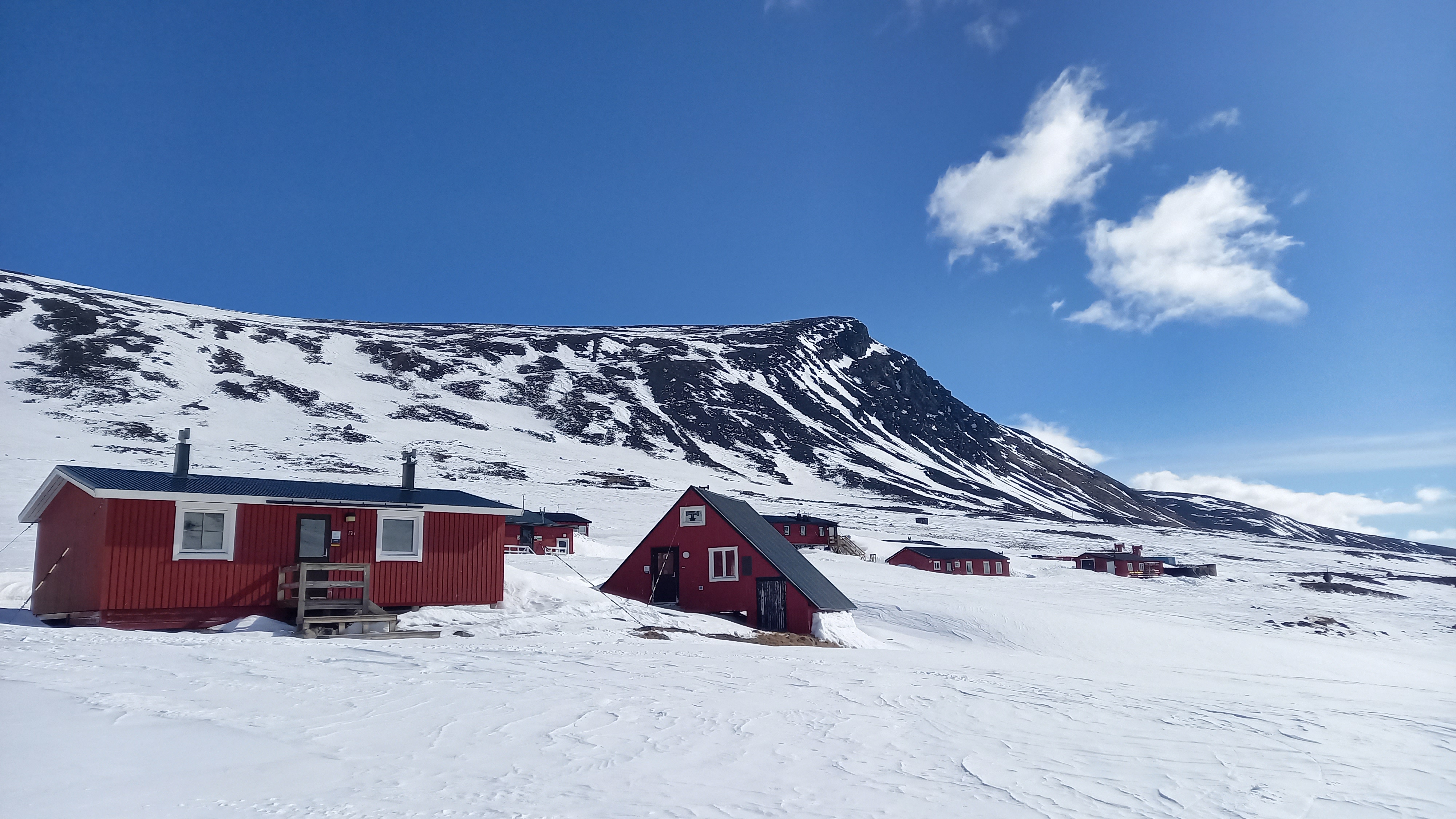
Tarfala Research Station is a centre for glaciological and alpine research at Stockholm University, Sweden.

Location

Tarfala Research Station is located at 1130 m a.s.l. in the high-alpine Kebnekaise Mountains, northern Sweden. It is Sweden's only research station in a high alpine arctic environment surrounded by glaciers. The nearest settlement is the Sami village Nikkaluokta, 24 km southeast of the station. There is a mountain tourist station (STF Kebnekaise fjällstation) ca 7 km from TRS, and a tourist hut (STF Tarfalastuga) ca 1 km from TRS.

Climate data

Grey colours are WMO Climate Normals including maximum and minimum values. Blue colours are individual years.

Climate data for the stations where extracted via Copernicus Climate Data Store, from the global gridded reanalysis product: ERA5 monthly averaged data on single levels from 1940 to present. Description and source code: Roemer J.K. 2023. https://doi.org/10.5281/zenodo.10214922 Data Source: Hersbach et al. 2023. Copernicus Climate Change Service (C3S) Climate Data Store (CDS), https://doi.org/10.24381/cds.f17050d7

Biodiversity and natural environment

Tarfala Research Station is surrounded by Sweden's highest mountains and several glaciers, and it is embedded in a time-machine like natural laboratory since climate warming is more pronounced in the Arctic ("Arctic Amplification"); this fuels a rapid decay of the small and vulnerable Swedish glaciers , and a rapid emergence of postglacial terrestrial and aquatic environments and associated changes in hydrological regimes and ecosystems can therefore be studied at and around TRS. Lake Tarfala, ca 1 km from TRS, is an exceptionally deep arctic alpine lake (51 m) that is seasonally ice covered and dimictic. Permafrost in the area is patchy, and vegetation ranges from high-alpine flora to mountain birch forest at the tree-line.

History and facilities

TRS was officially inaugurated in 1961 as an infrastructure for research in glaciology and geomorphology at Stockholm University. TRS is usually open from the end of March to the beginning of May, and from the end of June to mid- September. All outdoor activities, including transport to and from the station, are dependent on variable mountain weather. It is therefore recommended that you include extra time in your stay to allow for periods when fieldwork and/or transport may not be feasible. TRS can accommodate up to 28 guests at a time, in 2- and 4-person bedrooms in houses with running water and dry and/or incineration toilets. All meals are included – breakfast and dinner are served in the galley, lunch is usually a packed lunch for all heading into the field. There is no possibilities for self-house hold. TSR has two showers in the service building, where also the sauna is located. Tarfalajokk runs by the service house, providing refreshing cold water between sauna rounds. TRS has a modern lecture hall seating ca. 30 persons, a mechanical workshop and a simple wet-laboratory. Please contact the station manager if you want to use the workshop and/or the laboratory. Mobile phone reception is unreliable around Tarfala, but usually works relatively well in the Tarfala valley if you use the operators Telia or Tele2. TRS location in an Arctic and alpine setting far from the nearest road and medical assistance, imposes particular requirements when it comes to safety, both during fieldwork and at the station. We therefore have safety and etiquette rules which shall be followed by everyone at the station, both staff and visitors, so that we together can experience our beautiful work place in a safe and enjoyable way. Our safety regulations are based on recommendations from the Swedish Consumer Agency (a government agency whose task it is to safeguard consumer interests) and have been produced in collaboration with representative from the Swedish Mountain Rescue.

General research and databases

TRS is Sweden’s only research station located in an alpine arctic environment surrounded by glaciers. Here we conduct high quality, internationally recognised scientific research on Swedish alpine and glacial environments. We do both disciplinary and interdisciplinary research, with links to the effects of climate change on the global cryosphere and with focus on Swedish glaciers. Long term observations of watercourses and ecosystems are also carried out alongside long term observations of the changing state of glaciers. The data is made available with open-access through different databases. TRS is also a platform for field-based teaching, which is available for both international and national students and teachers. TRS also collaborates with non-academic actors who are active in the unique environment around the station, and communicates relevant research results to a wide range of target groups. We welcome researchers and academic courses from various subject areas and universities, academic workshops and meetings! An important component of the research conducted at TRS is the continually measurement of Storglaciären’s mass balance which has been ongoing since 1946, and is included in the World Glacier Monitoring Service’s database. The mass balance dataset from Storglaciären is the longest of its kind in the World and engages both the general public and researchers across the globe. The measurements have helped shape a comprehensive knowledge of the interaction between the glacier and climate, local temperatures and precipitation changes, which together play an important role in our understanding of glacier dynamics. TRS is also responsible for measuring the annual height of Kebnekaise’s southern peak, which determines the highest point in Sweden and thus generates great public interest. On 11 August 2023, the southern peak of Kebnekaise was measured at 2,093.2 meters, which was lower than the northern peak (2097 m). It is the lowest altitude that has been measured since the measurements started in 1902.

Link to data: https://dataportal.eu-interact.org/stations

Station Monitoring

Human dimension

The nearest village is Nikkaluokta, inhabited by c. 30, mainly Sami people.

Access

Travel to TRS is recommend to go via Kiruna and Nikkaluokta. Kiruna is served by train and plane from Stockholm. Nikkaluokta is served by bus from Kiruna (c 60 km). From Nikkaluokta, TRS is reached by a 24 km long trail hike (summer), or by skies or snowmobile (winter). Helicopters operate from Nikkaluokta during high season, and from Kiruna during low season. At TRS we strive to minimise our carbon footprint by choosing the most climate friendly modes of transportation to and from the station.

Member of: