Kevo Subarctic Research Station
Address
Kevo Subarctic Research StationKevontie 470
99980 Utsjoki
Finland
Station manager
Otso SuominenStation Features
Opening year: 1958 Status: Open- Type of station: Station
- Operational period: Year-round
- Name of station owner: University of Turku
- Type of owner: Government
- Name of managing institution: Kevo Subarctic Research Institute, University of Turku
- Managing Institution Country: Finland
- Station owner country: Finland
- Partner institution: No
- Station latitude: 69,75699167
- Station longitude: 27,00914722
- Country (station location): Finland
- Altitude of station: 80 m a.s.l
- Min. altitude within study area: 75 m a.s.l
- Max. altitude within study area: 500 m a.s.l
- Nearest town/settlement: Utsjoki
- Distance to nearest town/settlement: 20 km
- Number of residents in nearest town: 600
- Distance to nearest public transport facility (Airport, Ferry terminal, Train station, Bus station): 155 km
- Distance to nearest research station: 125 km
- Maps available at station: Maps (1:20 000, 1:50 000), aerial images, satellite images, vegetation map, map of quatenary deposits, hiking maps
- Type of surface facility is built on: Rock
- Climate zone: Sub-Arctic
- Period of measurements for climate data below: 1981-2010
- Mean annual temperature: -1,6 °C
- Mean temperature in February: -13,7 °C
- Mean temperature in July: 12,9 °C
- Min. Temp. (absolute): -48,2 °C
- Max. Temp. (absolute): 33,4 °C
- Precipitation type: Snow, Rain
- Snow free period (month to month): May/June - October
- Lake ice break up: May, June
- River ice break up: May, June
- Dominant wind direction: West
- Mean annual wind speed: 2,7 m/s
- Date of maximum wind speed: Wednesday, 12 March 1997
- Maximum wind speed (absolute): 26 m/s
- Landscape features Mountains, Valleys, Lake, River
- Permafrost zone Sporadic
- Vegetation zone Tree line, Shrub tundra, Gramminoid tundra, Forest tundra, Peatlands, Wetlands, Deciduous forest, Evergreen forest
- Wildlife Terrestrial carnivores, Ungulates, Hares, Rodents, Fish
- Human use Settlement, Fishing, Hunting, Tourism
Facilities
- Area under roof: 3000 m²
- Max. number of visitors at a time : 70
- Showers: Yes
- Laundry facilities: Yes
- Power supply - period: 24 h
- Power supply - plug type C, F
- Power sources at station Municipal grid, Diesel/oil/gas, Wood, Geothermal
- Logistics area: 1000 m²
- Conference room capacity: 50
- Workshops Metal, Wood
- Means of transportation to/from station Walk, Car, Bus, Ski, Snowmobile, Boat
- Transport on land - at station ATV, Snowmobile, Car, Other, Bicycles, Ski, Snow shoes
- Transport on water - at station Open boat/Dhinghy
- Water landing facilities Pontoon/float bridge, Warf/pier
- Number of staff peak season/summer: 12
- Number of staff off season/winter: 7
- Staff able to assist (fieldwork): Yes - if time allows
- Staff able to assist (workshops): Yes - if time allows
- Laboratory area: 750 m²
- Laboratory equipment Freezer < -80, Freezer -40 - -10, Fridge, Microscopes, Basic laboratory equipment, Basic chemical reagents
- Field to station Mobile phone
- Station to outside world Mobile phone, Internet
- IT Infrastructure Wifi, Computers, Printer
- Medical facilities: No
- Medical capability Basic
- Staff with medical training/doctor No
- Distance to hospital (estimated time – hours): 2
- Recommended safety equipment Mobile phone, GPS, First aid kit
- Safety equipment available at station GPS, First aid kit
- Camping equipment available at station Tent, Sleeping matress, Sleeping bag, Cooking equipment and utensils, Gas/alcohol for cooking
Science
- Arctic Council working groups
- AMAP - Arctic Monitoring and Assessment Programme (Arctic), http://www.amap.no/
- Circumpolar Biodiversity Monitoring Programme (Arctic), https://www.caff.is/monitoring
- Scientific networks
- Herbivory network (Global), http://herbivory.biology.ualberta.ca/
- iLTER - International Long Term Ecological Research (Global), https://lternet.edu/international/
- INTERMAGNET - International Real-time Magnetic Observatory Network (Global), http://www.intermagnet.org/index-eng.php
- IPA - CALM - Circumarctic Active Layer Monitoring (Arctic), https://www2.gwu.edu/~calm/
- NeAT - Network for Arthropods of the Tundra (Global), https://tundraarthropods.wordpress.com/
- Transnational Access: Yes
- Remote Access: Yes
- INTERACT Virtual Access: Yes
-
Permitting issues categories
- Permits required for access to the station
- Permits required for studies
-
Partner institutions (involved in the operation of the station)
- Partner institution
-
Climate
- Snow
- Rain
- Hail
-
Housing and accomodation
- Showers
- Laundry facilities
- A
- B
- C
- D
- E
- F
- G
- H
- I
- J
- K
- L
- M
- N
- Municipal grid
- O
- Diesel/oil/gas
- Wood
- Solar
- Wind
- Water
- Geothermal
- Biofuel
- Other
-
Logistics
- Electrical and IT technologies
- Mechanical
- Metal
- Wood
- Plexiglas
- Other
- Walk
- None
- Tracked vehicle
- Truck
- SUV (4x4)
- Car
- ATV
- Zodiac
- Snowmobile
- Open boat/Dhinghy
- Bicycles
- Closed boat
- Ski
- Amphibie vehicle
- Snow shoes
- Other
- KickSledges
- Other
- Ski
- Snowmobile
- Boat
- Car
- Tracked vehicle
- Truck
- SUV (4x4)
- Bus
- Train
- Airstrip
- Scheduled flight
- Chartered plane/helicopter
- Helipad
- None
- Other
- Harbour/port
- Warf/pier
- Pontoon/float bridge
- Barges
- Beach
-
Aircraft landing facilities
- Helipad
-
Features in the facility area
- Permanent snowpatches
- Mountain
- Valley
- Lake
- River
- Shoreline
- Tree line
- Polar deserts/semi-deserts
- Shrub tundra
- Gramminoid tundra
- Forest tundra
- Peatlands
- Wetlands
- Palsa mires
- Deciduous forest
- Evergreen forest
- Human settlements or resource use in the area
- Arable land
- Other
-
Main science disciplines
- Astronomy
- Atmospheric sciences
- Cryology
- Geology
- Hydrology
- Limnic biology
- Marine biology
- Terrestrial biology
- Human biology
- Anthropology
- Archaeology
- Sociology
- Climate change
- Environmental science (incl. pollution)
- Oceanography
- Agriculture
- Animal husbandry
- Fisheries
- Forestry
- Hunting
- Tourism
-
Workshop facilities
- Metal workshop
- Wood workshop
- Plexiglas workshop
- Staff available to assist with constructions
-
Communication
- Telephone
- Satellite phone
- VHF
- Internet
- Computer
- Printer
- Scanner
- Fax
-
Meteorology
- Air temperature
- Air humidity
- Air pressure
- Wind velocity
- Wind direction
- Precipitation
-
Energy balance and radiation
- Energy balance
- Short wave incoming
- Short wave outgoing
- Long wave incoming
- Long wave outgoing
- Net radiation
- UV-B
- Multi-spectral
- Cloud cover/hours of sunshine
-
Geology/Geomorphology
- Quaternary geology
- Sedimentology
- Bedrock geology
- Erosion
-
Geophysics and Geodesy
- Gravity
- Magnetic field
- Aurora
- Seismic activity
-
Sub-surface characteristics
- Ground surface temperature
- Soil temperature
- Soil moisture
- Ground water table
- Soil water chemistry
- Active layer depth
- Permafrost distribution
- Permafrost thickness
- Permafrost temperature
-
Snow characteristics
- Snow depth
- Snow cover
- Snow density
- Snow temperature
-
Atmospheric composition
- CO<sub>2</sub> concentration
- CH<sub>4</sub> concentration
-
Energy budget
- Net radiation
- Sensible heat flux
- Latent heat flux
- Soil heat flux
-
Hydrology/Limnology
- River water discharge/water level
- Lake water level
- Water balance
- Water temperature
- Lake ice cover (formation/breakup/thickness)
- Suspended sediment discharge
- Organic matter discharge
- PAR (Photosyntetically Active Radiation)/secchi depth
- Water chemistry
-
Pollution
- In air
- In water
- In soil
- In snow/ice
- Contaminants in species
-
Vegetation
- Flowering phenology
- Amount of flowering
- NDVI (plot/transect)
- Landscape NDVI (from satellite images)
- Vascular plant community composition
- Bryophyte community composition
- Lichen community composition
- Fungi community composition
- Berry production
- Aerobiological monitoring (pollen, spores, etc.)
- Species list (community composition)
-
Arthropods
- Abundance
- Emergence phenology
- Insect herbivory
- Species list (community composition)
-
Birds
- Abundance
- Distribution
- Phenology
- Breeding birds
- Nest initiation phenology
- Nest predation rates
- Species list (community composition)
-
Mammals
- Mammal abundance
- Mammal distribution
- Mammal reproduction
- Mortality
- Predation
- Physiology
- Species list (community composition)
-
Pollution
- Pollution measurements in vegetation
- Pollution measurements in water
- Pollution measurements in mammals (body burdens, biomarkers)
- Pollution measurements in birds (body burdens, biomarkers on both adults and offspring e.g. egg shell thinning, macro plastic in nests/in body)
-
Landscape and environment
- Mountains
- Nunataks
- Volcano/crater
- Lava fields
- Plateaus
- Moraines
- Valleys
- Homothermic Springs
- Lake
- Thermokarst lake
- River
- Delta/estuarie
- Fjord
- Sea
- Continuous
- Discontinuous
- Beach
- Sporadic
- Rocky shores
- Pingos/ice lenses
- Sea cliffs
- Other (text)
- Palsa mires
- None
- Ice Caps
- Glaciers
- Permanent snow patches
- None
- Tree line
- Polar desert/Semi-desert
- Gramminoid tundra
- Shrub tundra
- Forest tundra
- Wetlands
- Peatlands/mires
- Salt marshes/lagoons
- Heath
- Grassland
- Deciduous forest
- Evergreen forest
- Terrestrial carnivores
- Ungulates
- Alpine heath
- Hares
- Other (text)
- Rodents
- Bird colonies
- Polar bear
- Whales
- Seals
- Fish
- Settlement
- Fishing
- Hunting
- Forestry
- Agriculture
- Tourism
- Animal husbandry
- Leisure activities
-
Laboratory
- Freezer < -80
- Freezer -40 - -10
- Fridge
- Microscopes
- Basic laboratory equipment
- Advanced laboratory equipment
- Basic chemical reagents
- Analytical instrumentation
- Other
- Laboratory available in nearby town/settlement
-
Communication and IT
- Mobile phone
- VHF
- Satellite phone
- Other
- Satellite phone
- Mobile phone
- Internet
- Other
- Wireless transfer of data from field site to station
- Wifi
- Computers
- Printer
- Data storage
- Statistical tools
- GIS tools
- Other
-
Medical facilities
- Medical facilities
- Basic
- Medium
- Extensive
- Dental
- Surgery
- Other
- No
- In peak season
- When open
-
Field equipment
- PLB
- VHF
- HF
- Satellite phone
- Mobile phone
- GPS
- Weapon/rifle
- Flare gun
- Bearspray
- PLB
- First aid kit
- Glacier rescue kit
- VHF
- Avalanche rescue kit
- HF
- Satellite phone
- Overnight equipment
- Mobile phone
- Other
- GPS
- Weapon/rifle
- Flare gun
- Bearspray
- PLB
- First aid kit
- Glacier rescue kit
- VHF
- Avalanche rescue kit
- HF
- Satellite phone
- Overnight equipment
- Other
- Mobile phone
- GPS
- Weapon/rifle
- Flare gun
- Bearspray
- Tent
- First aid kit
- Sleeping matress
- Glacier rescue kit
- Sleeping bag
- Avalanche rescue kit
- Cooking equipment and utensils
- Overnight equipment
- Gas/alcohol for cooking
- Other
- Field power supply available at station
Station name and owner
The Kevo Subarctic Research Station is managed by the Kevo Subarctic Research Institute which is based at the University of Turku.
Location
Kevo Subarctic Research Station is located in Utsjoki at the northernmost tip of Finland only about hundred kilometres from the coast of the Arctic Ocean (69°45’ N, 27°01’ E) right next to Kevo Strict Nature Reserve (712 km2). It lies about 60 km north of the continuous pine forest line and belongs to the subarctic Mountain Birch Forest Zone close to both the local pine tree line and the birch tree line at the forest-tundra ecotone.
Climate data
Grey colours are WMO Climate Normals including maximum and minimum values. Blue colours are individual years.
Climate data for the stations where extracted via Copernicus Climate Data Store, from the global gridded reanalysis product:
ERA5 monthly averaged data on single levels from 1940 to present.
Description and source code: Roemer J.K. 2023. https://doi.org/10.5281/zenodo.10214922
Data Source: Hersbach et al. 2023. Copernicus Climate Change Service (C3S) Climate Data Store (CDS), https://doi.org/10.24381/cds.f17050d7
Biodiversity and natural environment
The station is close to a wide range of ecosystems from pine stands at low altitudes to mountain birch forests and low alpine tundra as well as mires (also palsas), lakes, and rivers. Several large-scale outbreaks of birch feeding moth larvae are characteristic for the birch forests. The latest outbreak in 2005-2009 destroyed about 400 km2 of the treeline birch forests in Utsjoki. Grazing by semi-domesticated reindeer is another important factor that shapes the ecosystems. The area is part of the basin of the river Teno/Tana which is one of the top salmon rivers in Europe.
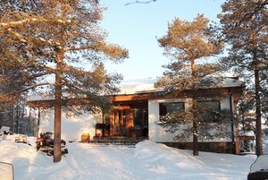
History and facilities
The station was founded in 1958. The station, including a weather station of Finnish Meteorological Institute, consists of several buildings. It has the capacity to accommodate about 50 guests. It is open year-round. The station provides laboratories, a workshop, a lecture hall, and accommodation buildings. During recent years the station has had about 100 Finnish and 70 foreign visiting scientists each year.
General research and databases
Kevo Subarctic Research Station has got a long tradition in manipulative experiments addressing cause-effect relationships of anthropogenic environmental changes. In ecological science it is known for the research on plant herbivore interactions and in geographical science for research on palsa mires. There are long-term field experiments studying the effects of aerial pollutants and the impacts of reindeer grazing. The station has got arboretums with different origins of arctic treeline species. There is monitoring data available on population dynamics of moths, rodents, birds, plant phenology, pollen deposits, and meteorological data. The station also holds up to 50-year old bio-geographical mapping data of the surrounding area.
Link to data: https://dataportal.eu-interact.org/stations
Station Monitoring
-
Climate
- Meteorology
- Energy balance and radiation
-
Geo
- Geology/Geomorphology
- Geophysics and Geodesy
- Sub-surface characteristics
- Snow characteristics
- Atmospheric composition
- Energy budget
- Hydrology/Limnology
- Pollution
-
Bio
- Vegetation
- Arthropods
- Birds
- Mammals
- Pollution
Human dimension
Utsjoki is the only municipality in Finland with Sámi majority for whom the traditional reindeer herding and fishing are still important livelihoods, even though it is in general a normal modern community with modern services. In Utsjoki village (18 km north of Kevo) there are grocery shops, a post office, a library, a swimming hall, accommodation providers, pubs, a bank, and a health centre. Anthropological, sociological, and archaeological studies on the local community have been managed by the research station.
Access
The station is located close to a main road and can be reached by car. Access to the station is across Lake Kevojärvi (250 m, in summer by boat and in winter over the ice) or via a small road (5 km). The closest airport in Finland is in Ivalo with a bus connection from Ivalo to Kevo (c. 150 km). There are also airports in Norway at about the same distance (Lakselv, Vadsø, Kirkenes). Alternatively, a train connection exists from southern Finland to Rovaniemi followed by a bus trip via Ivalo to Kevo (450 km).