Address

Station manager

Rainer Prinz
E-mail: rainer.prinz@uibk.ac.at

Contact Station

E-mail: rainer.prinz@uibk.ac.at

https://www.uibk.ac.at/projects/station-hintereis-opal-data/index.html.en

Station Features

Opening year: 1966 Status: Open
  • Type of station: Shelter
  • Operational period – year-round or Month A to Month B: Episodic
  • Name of station owner: Institut of Meteorology and Geophysics, University of Innsbruck
  • Type of owner: Research institution
  • Name of managing institution: Institut of Meteorology and Geophysics, University of Innsbruck
  • Managing Institution Country: Austria
  • Station owner country: Austria
  • Partner institution: No
  • Station latitude: 46,80360000
  • Station longitude: 10,76673889
  • Country (station location): Austria
  • Altitude of station: 3026 m a.s.l
  • Min. altitude within study area: 1900 m a.s.l
  • Max. altitude within study area: 3739 m a.s.l
  • Nearest town/settlement: Vent (Austria), Kurzras (Italy - glacier ski resort)
  • Distance to nearest town/settlement: 15 km
  • Number of residents in nearest town: 100
  • Distance to nearest public transport facility (Airport, Ferry terminal, Train station, Bus station): 15 km
  • Distance to nearest research station: 168 km
  • Maps available at station: Many maps and DTMs of all kinds since 1870; navigation: map of Austrian Alpine Club no. 30/2 ‘Weißkugel’ (1:25 000)
  • Type of surface facility is built on: Rock
  • Climate zone: Alpine
  • Climate zone: Boreal
  • Period of measurments for climate data below [year to year]: Many data sets from earlier periods (since 1847), temperature and wind data below since 2011
  • Mean annual temperature: -3,3 °C
  • Mean temperature in February: -12,2 °C
  • Mean temperature in July: 5,2 °C
  • Precipitation type: Snow, Rain
  • Snow free period (month to month): mid July - mid October
  • Dominant wind direction: Southwest
  • Mean annual wind speed: 4 m/s
  • Maximum wind speed (absolute): 24 m/s
  • Landscape features Mountains, Valleys, Lake, River
  • Permafrost zone Discontinuous
  • Snow and ice on land Ice Caps, Glaciers, Permanent snow patches
  • Vegetation zone Tree line, Shrub tundra, Peatlands, Evergreen forest
  • Human use Settlement

Facilities

  • Area under roof: 33,75 m²
  • Max. number of visitors at a time : 8
  • Showers: No
  • Laundry facilities: No
  • Power supply – period (from ‘hour’ to ‘hour’ or 24 hours): 1 kW generator on request
  • Power supply - plug type C, F
  • Conference room capacity: 0
  • Means of transportation to/from station Walk, Other
  • Air transport landing facilities at station Helipad
  • Airstrip (Length × Width) :
  • Number of staff peak season/summer: 0
  • Number of staff off season/winter: 0
  • Staff able to assist (fieldwork): No
  • Staff able to assist (workshops): No
  • Compulsory safety equipment Glacier rescue kit, Other, Satellite phone, Mobile phone, GPS, First aid kit, Avalanche rescue kit
  • Recommended safety equipment Other
  • Laboratory area: 0 m²

Science

  • Transnational Access: Yes
  • Remote Access: No
  • INTERACT Virtual Access: Yes
  • Permitting issues categories
    • Permits required for access to the station
    • Permits required for studies
  • Partner institutions (involved in the operation of the station)
    • Partner institution
  • Climate
    • Snow
    • Rain
    • Hail
  • Housing and accomodation
    • Showers
    • Laundry facilities
    • A
    • B
    • C
    • D
    • E
    • F
    • G
    • H
    • I
    • J
    • K
    • L
    • M
    • N
    • O
    • Municipal grid
    • Diesel/oil/gas
    • Wood
    • Solar
    • Wind
    • Water
    • Geothermal
    • Biofuel
    • Other
  • Logistics
    • Electrical and IT technologies
    • Mechanical
    • Metal
    • Wood
    • Plexiglas
    • Other
    • Walk
    • None
    • Tracked vehicle
    • Truck
    • SUV (4x4)
    • Car
    • ATV
    • Zodiac
    • Snowmobile
    • Open boat/Dhinghy
    • Closed boat
    • Bicycles
    • Amphibie vehicle
    • Ski
    • Other
    • Snow shoes
    • KickSledges
    • Other
    • Ski
    • Snowmobile
    • Boat
    • Car
    • Tracked vehicle
    • Truck
    • SUV (4x4)
    • Bus
    • Train
    • Airstrip
    • Scheduled flight
    • Helipad
    • Chartered plane/helicopter
    • Other
    • None
    • Harbour/port
    • Warf/pier
    • Pontoon/float bridge
    • Barges
    • Beach
  • Aircraft landing facilities
    • Helipad
  • Features in the facility area
    • Permanent snowpatches
    • Mountain
    • Valley
    • Lake
    • River
    • Shoreline
    • Tree line
    • Polar deserts/semi-deserts
    • Shrub tundra
    • Gramminoid tundra
    • Forest tundra
    • Peatlands
    • Wetlands
    • Palsa mires
    • Deciduous forest
    • Evergreen forest
    • Human settlements or resource use in the area
    • Arable land
    • Other
  • Main science disciplines
    • Astronomy
    • Atmospheric sciences
    • Cryology
    • Geology
    • Hydrology
    • Limnic biology
    • Marine biology
    • Terrestrial biology
    • Human biology
    • Anthropology
    • Archaeology
    • Sociology
    • Climate change
    • Environmental science (incl. pollution)
    • Oceanography
    • Agriculture
    • Animal husbandry
    • Fisheries
    • Forestry
    • Hunting
    • Tourism
  • Workshop facilities
    • Metal workshop
    • Wood workshop
    • Plexiglas workshop
    • Staff available to assist with constructions
  • Communication
    • Telephone
    • Satellite phone
    • VHF
    • E-mail
    • Internet
    • Computer
    • Printer
    • Scanner
    • Fax
  • Meteorology
    • Air temperature
    • Air humidity
    • Air pressure
    • Wind velocity
    • Wind direction
    • Precipitation
  • Energy balance and radiation
    • Energy balance
    • Short wave incoming
    • Short wave outgoing
    • Long wave incoming
    • Long wave outgoing
    • Net radiation
    • UV-B
    • Multi-spectral
    • Cloud cover/hours of sunshine
  • Sub-surface characteristics
    • Ground surface temperature
    • Soil temperature
    • Soil moisture
    • Ground water table
    • Soil water chemistry
    • Active layer depth
    • Permafrost distribution
    • Permafrost thickness
    • Permafrost temperature
  • Snow characteristics
    • Snow depth
    • Snow cover
    • Snow density
    • Snow temperature
  • Hydrology/Limnology
    • River water discharge/water level
    • Lake water level
    • Water balance
    • Water temperature
    • Lake ice cover (formation/breakup/thickness)
    • Suspended sediment discharge
    • Organic matter discharge
    • PAR (Photosyntetically Active Radiation)/secchi depth
    • Water chemistry
  • Glacier characteristics
    • Glacier area
    • Topography
    • Elevation change
    • Terminus position
    • Ice velocity
    • Ice thickness
    • Debris cover
    • Surface albedo/reflexion coefficient
  • Mass balace
    • Mass balance
    • Snow water equivalent
    • Snowcover stratigraphy
    • Equilibrium Line Altitude
    • Duration of snow cover
    • Calving flux
  • Climate
    • Climate measurements
    • Energy balance
  • Landscape and environment
    • Mountains
    • Nunataks
    • Volcano/crater
    • Lava fields
    • Plateaus
    • Moraines
    • Valleys
    • Homothermic Springs
    • Lake
    • Thermokarst lake
    • River
    • Delta/estuarie
    • Fjord
    • Continuous
    • Sea
    • Discontinuous
    • Beach
    • Sporadic
    • Rocky shores
    • Pingos/ice lenses
    • Sea cliffs
    • Other (text)
    • Palsa mires
    • Ice Caps
    • None
    • Glaciers
    • Permanent snow patches
    • None
    • Tree line
    • Polar desert/Semi-desert
    • Gramminoid tundra
    • Shrub tundra
    • Forest tundra
    • Wetlands
    • Peatlands/mires
    • Salt marshes/lagoons
    • Heath
    • Grassland
    • Deciduous forest
    • Evergreen forest
    • Terrestrial carnivores
    • Alpine heath
    • Ungulates
    • Hares
    • Other (text)
    • Rodents
    • Bird colonies
    • Polar bear
    • Whales
    • Seals
    • Fish
    • Settlement
    • Fishing
    • Hunting
    • Forestry
    • Agriculture
    • Tourism
    • Animal husbandry
    • Leisure activities
  • Field equipment
    • PLB
    • VHF
    • HF
    • Satellite phone
    • Mobile phone
    • GPS
    • Weapon/rifle
    • Flare gun
    • Bearspray
    • PLB
    • First aid kit
    • Glacier rescue kit
    • VHF
    • Avalanche rescue kit
    • HF
    • Satellite phone
    • Overnight equipment
    • Other
    • Mobile phone
    • GPS
    • Weapon/rifle
    • Flare gun
    • Bearspray
    • PLB
    • First aid kit
    • Glacier rescue kit
    • VHF
    • Avalanche rescue kit
    • HF
    • Satellite phone
    • Overnight equipment
    • Other
    • Mobile phone
    • GPS
    • Weapon/rifle
    • Flare gun
    • Bearspray
    • Tent
    • First aid kit
    • Glacier rescue kit
    • Sleeping matress
    • Avalanche rescue kit
    • Sleeping bag
    • Cooking equipment and utensils
    • Overnight equipment
    • Other
    • Gas/alcohol for cooking
    • Field power supply available at station
  • Laboratory
    • Freezer < -80
    • Freezer -40 - -10
    • Fridge
    • Microscopes
    • Basic laboratory equipment
    • Advanced laboratory equipment
    • Basic chemical reagents
    • Analytical instrumentation
    • Other
    • Laboratory available in nearby town/settlement
  • Glacier hydrology
    • Run-off
    • Supra-, en- and subglacial drainage system
    • Meltwater retention
    • Glacial lake outburst floods

Station name and owner

Station Hintereis (STHE) is situated near Hintereisferner (HEF) in the catchment of the Rofen Valley. The Department of Atmospheric and Cryospheric Sciences, University of Innsbruck (ACINN) runs the station which is built on land owned by the Austrian Governmental Forestry Administration.

Location

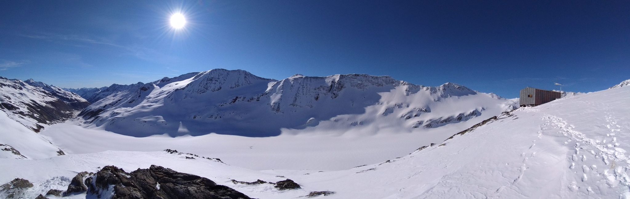
The STHE is situated 200 m from the 1970s mean equilibrium line of HEF, an approximately 5 km2 valley glacier. HEF is one of several glaciers in the high alpine catchment of Rofenache (Rofen river), Ötztal Alps, Austria, on the border to Italy.

Climate data

Grey colours are WMO Climate Normals including maximum and minimum values. Blue colours are individual years.

Climate data for the stations where extracted via Copernicus Climate Data Store, from the global gridded reanalysis product: ERA5 monthly averaged data on single levels from 1940 to present. Description and source code: Roemer J.K. 2023. https://doi.org/10.5281/zenodo.10214922 Data Source: Hersbach et al. 2023. Copernicus Climate Change Service (C3S) Climate Data Store (CDS), https://doi.org/10.24381/cds.f17050d7

Biodiversity and natural environment

STHE is totally surrounded by alpine glaciers covering peaks as high as almost 3800 m a.s.l. The immediate surroundings of the HEF are characterized by freshly exposed rocks and debris resulting from ongoing glacial retreat. Prominent Little Ice Age moraines dominate the surroundings of the glacier tongue. Due to its high elevation and somehow difficult access, ST-HE is not suitable for studying the lower parts of the Rofen Valley. Main focus is on glaciology and atmospheric studies.

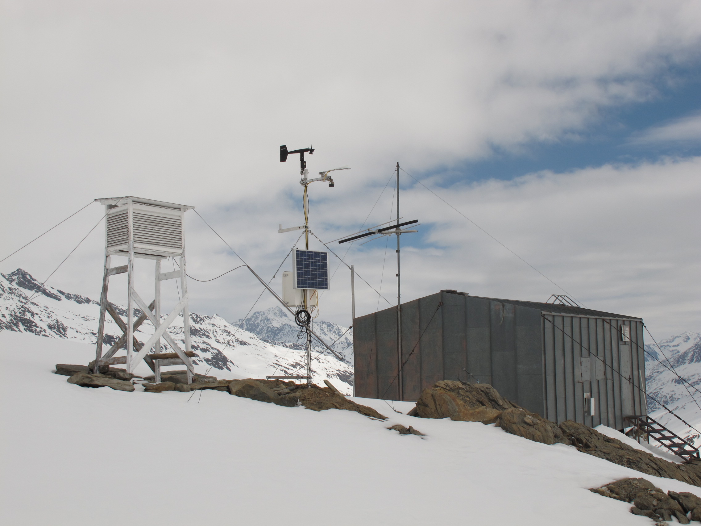
History and facilities

HEF is mentioned in 1601 for the first time and then in 1678, 1774, 1770, 1816 in the context of pro-glacial lake formation and related glacial lake outburst floods. Glacier extent observations began in 1847, and the earliest maps are from 1870, 1888, and 1893, followed by a long series of maps. Research was intensified since the International Geophysical Year and during the International Hydrologica Decade/Program of UNESCI/IHP. HEF has been the key research site for glaciological studies at IMGI ever since. In 1966, SH was built to logistically support the ongoing scientific activities. It accommodates up to eight persons in bunk beds. There is no electricity but gas for cooking, heating, and light.

General research and databases

HEF has one of the longest time series on glacier mass balance for any glaciers on Earth, based on series of geodetic maps starting in the 19th century. Since 2001 1-2 airborne LIDAR surveys are carried out per year for determining ice volume changes. Length changes have been measured annually since 1847, and a mass balance time series dates back to 1953. Complementary studies of ice-atmopshere interactions, ice dynamics, and glacier hydrology has accumulated rich data sets.

Link to data: https://dataportal.eu-interact.org/stations

Station Monitoring

Human dimension

The nearest settlements are Vent in Austria, 15 km from STHE (150 permanent inhabitants, alpine farming and tourism) and Kurzras/Maso Corto and Schnals/Senales in Italy (approximately 10 permanent inhabitants, year-round glacier ski tourism).

Access

STHE is accessed from Innsbruck Airport either by car (2 hours) or train/bus (3 hours) to Vent. From there, it is a 6-7 hours walk to the station (1200 m elvation gain). The Hochjoch Hospiz mountain hut is half way. Glacier crossing is necessary, thus safety equipment and moutaineering experience are mandatory. Helicopter charter is possible but expensive.

Member of: