Sonnblick Observatory
Address
Sonnblick Observatory
Freisaalweg 16
5020 Salzburg
Österreich
Station manager
Elke LudewigStation Features
Opening year: 1886 Status: Open- Type of station: Station
- Operational period: Year-round
- Name of station owner: ZAMG
- Type of owner: Research institution
- Name of managing institution: Zentralanstalt für Meteorologie und Geodynamik
- Managing Institution Country: Austria
- Station owner country: Austria
- Partner institution: No
- Station latitude: 47,05416667
- Station longitude: 12,95777778
- Country (station location): Austria
- Altitude of station: 3106 m a.s.l
- Min. altitude within study area: 1600 m a.s.l
- Max. altitude within study area: 3254 m a.s.l
- Nearest town/settlement: Rauris (3050 inhabitants)
- Distance to nearest town/settlement: 20 km
- Number of residents in nearest town: 3050
- Distance to nearest public transport facility (Airport, Ferry terminal, Train station, Bus station): 200 km
- Distance to nearest research station: 168 km
- Maps available at station: Maps (1:50 000, 1:25 000), height models 1m - 25m, aerial images. Data on permafrost and glacier measurements.
- Climate zone: Alpine
- Climate zone: Boreal
- Period of measurements for climate data below: 125
- Mean annual temperature: -5,7 °C
- Mean temperature in February: -11,2 °C
- Mean temperature in July: 1,8 °C
- Precipitation type: Snow, Rain
- Dominant wind direction: Southwest
- Mean annual wind speed: 5,6 m/s
- Maximum wind speed (absolute): 67 m/s
- Landscape features Mountains, Valleys
- Permafrost zone Discontinuous
- Snow and ice on land Ice Caps, Glaciers, Permanent snow patches
Facilities
- Area under roof: 200 m²
- Max. number of visitors at a time : 10
- Showers: No
- Laundry facilities: No
- Power supply - period: 24 h
- Power supply - plug type C, F
- Power sources at station Municipal grid, Solar
- Logistics area: 0 m²
- Workshops Metal, Plexiglas, Wood
- Means of transportation to/from station Other, Car, Bus
- Air transport landing facilities at station Helipad
- Airstrip (Length × Width) : –
- Number of staff peak season/summer: 2
- Number of staff off season/winter: 2
- Staff able to assist (fieldwork): Yes - if time allows
- Staff able to assist (workshops): Yes - if time allows
- Compulsory safety equipment Glacier rescue kit
- Recommended safety equipment Other
- Laboratory area: 20 m²
- Laboratory equipment Freezer -40 - -10, Fridge, Basic laboratory equipment, Other
- Field to station Mobile phone, VHF
- Station to outside world Mobile phone, Internet
- Wireless transfer of data from field site to station: Yes
- IT Infrastructure Computers, Printer, Other
- Medical facilities: Yes
- Medical capability Basic
- Distance to hospital (estimated time – hours): 0
Science
- Scientific networks
- BSRN - Baseline Surface Radiation Network (Global), http://bsrn.awi.de/
- GTN-G - Global Terrestrial Network - Glaciers (Global), http://www.gtn-g.ch/
- GTN-P - Global Terrestrial Network - Permafrost (Global), http://gtnp.arcticportal.org/
- NDACC - Network for the Detection of Atmospheric Composition Change (Global), http://www.ndaccdemo.org/
- WMO - GAW - Global Atmosphere Watch (Global), http://www.wmo.int/pages/prog/arep/gaw/gaw_home_en.html
- WMO - GCOS - Global Climate Observing System (Global), https://gcos.wmo.int/
- WMO - GCW - Global Cryosphere Watch (Global), http://globalcryospherewatch.org/cryonet/
- WGMS - World Glacier Monitoring Service (Global), http://wgms.ch/
- WMO - World Meteorological Organisation (Global), https://public.wmo.int/en
- Transnational Access: Yes
- Remote Access: Yes
- INTERACT Virtual Access: Yes
-
Permitting issues categories
- Permits required for access to the station
- Permits required for studies
-
Partner institutions (involved in the operation of the station)
- Partner institution
-
Climate
- Snow
- Rain
- Hail
-
Housing and accomodation
- Showers
- Laundry facilities
- A
- B
- C
- D
- E
- F
- G
- H
- I
- J
- K
- L
- M
- N
- Municipal grid
- O
- Diesel/oil/gas
- Wood
- Solar
- Wind
- Water
- Geothermal
- Biofuel
- Other
-
Logistics
- Electrical and IT technologies
- Mechanical
- Metal
- Wood
- Plexiglas
- Other
- Walk
- None
- Tracked vehicle
- Truck
- SUV (4x4)
- Car
- ATV
- Zodiac
- Snowmobile
- Open boat/Dhinghy
- Closed boat
- Bicycles
- Amphibie vehicle
- Ski
- Other
- Snow shoes
- KickSledges
- Other
- Ski
- Snowmobile
- Boat
- Car
- Tracked vehicle
- Truck
- SUV (4x4)
- Bus
- Train
- Airstrip
- Scheduled flight
- Helipad
- Chartered plane/helicopter
- Other
- None
- Harbour/port
- Warf/pier
- Pontoon/float bridge
- Barges
- Beach
-
Aircraft landing facilities
- Helipad
-
Features in the facility area
- Permanent snowpatches
- Mountain
- Valley
- Lake
- River
- Shoreline
- Tree line
- Polar deserts/semi-deserts
- Shrub tundra
- Gramminoid tundra
- Forest tundra
- Peatlands
- Wetlands
- Palsa mires
- Deciduous forest
- Evergreen forest
- Human settlements or resource use in the area
- Arable land
- Other
-
Main science disciplines
- Astronomy
- Atmospheric sciences
- Cryology
- Geology
- Hydrology
- Limnic biology
- Marine biology
- Terrestrial biology
- Human biology
- Anthropology
- Archaeology
- Sociology
- Climate change
- Environmental science (incl. pollution)
- Oceanography
- Agriculture
- Animal husbandry
- Fisheries
- Forestry
- Hunting
- Tourism
-
Workshop facilities
- Metal workshop
- Wood workshop
- Plexiglas workshop
- Staff available to assist with constructions
-
Communication
- Telephone
- Satellite phone
- VHF
- Internet
- Computer
- Printer
- Scanner
- Fax
-
Meteorology
- Air temperature
- Air humidity
- Air pressure
- Wind velocity
- Wind direction
- Precipitation
-
Energy balance and radiation
- Energy balance
- Short wave incoming
- Short wave outgoing
- Long wave incoming
- Long wave outgoing
- Net radiation
- UV-B
- Multi-spectral
- Cloud cover/hours of sunshine
-
Geology/Geomorphology
- Quaternary geology
- Sedimentology
- Bedrock geology
- Erosion
-
Geophysics and Geodesy
- Gravity
- Magnetic field
- Aurora
- Seismic activity
-
Sub-surface characteristics
- Ground surface temperature
- Soil temperature
- Soil moisture
- Ground water table
- Soil water chemistry
- Active layer depth
- Permafrost distribution
- Permafrost thickness
- Permafrost temperature
-
Snow characteristics
- Snow depth
- Snow cover
- Snow density
- Snow temperature
-
Atmospheric composition
- CO<sub>2</sub> concentration
- CH<sub>4</sub> concentration
-
Pollution
- In air
- In water
- In soil
- In snow/ice
- Contaminants in species
-
Glacier characteristics
- Glacier area
- Topography
- Elevation change
- Terminus position
- Ice velocity
- Ice thickness
- Debris cover
- Surface albedo/reflexion coefficient
-
Mass balace
- Mass balance
- Snow water equivalent
- Snowcover stratigraphy
- Equilibrium Line Altitude
- Duration of snow cover
- Calving flux
-
Climate
- Climate measurements
- Energy balance
-
Glacier hydrology
- Run-off
- Supra-, en- and subglacial drainage system
- Meltwater retention
- Glacial lake outburst floods
-
Bio-geochemistry of snow, ice and water
- Biogeochemistry of snow, ice and water
-
Particles and aerosols
- Particles and aerosols
-
Pollutants e.g. POPs and heavy metals in snow, ice and water
- Pollutants e.g. POPs and heavy metals, in snow, ice and water
-
Isotope chemistry of snow, ice and water
- Isotope chemistry of snow, ice and water
-
Vegetation
- Flowering phenology
- Amount of flowering
- NDVI (plot/transect)
- Landscape NDVI (from satellite images)
- Vascular plant community composition
- Bryophyte community composition
- Lichen community composition
- Fungi community composition
- Berry production
- Aerobiological monitoring (pollen, spores, etc.)
- Species list (community composition)
-
Arthropods
- Abundance
- Emergence phenology
- Insect herbivory
- Species list (community composition)
-
Birds
- Abundance
- Distribution
- Phenology
- Breeding birds
- Nest initiation phenology
- Nest predation rates
- Species list (community composition)
-
Mammals
- Mammal abundance
- Mammal distribution
- Mammal reproduction
- Mortality
- Predation
- Physiology
- Species list (community composition)
-
Genetics
- Collection of genetic material
-
Pollution
- Pollution measurements in vegetation
- Pollution measurements in water
- Pollution measurements in mammals (body burdens, biomarkers)
- Pollution measurements in birds (body burdens, biomarkers on both adults and offspring e.g. egg shell thinning, macro plastic in nests/in body)
-
Socio-ecological issues (disturbance)
- Number of visitors
- Surface activities (e.g. removal of vegetation, organisms, soil samples, ATV traffic, manipulations)
- Aircraft activities
- Emissions/discharge energy consumption, spill water, waste, garbage, atmospheric emissions, etc.)
-
Landscape and environment
- Mountains
- Nunataks
- Volcano/crater
- Lava fields
- Plateaus
- Moraines
- Valleys
- Homothermic Springs
- Lake
- Thermokarst lake
- River
- Delta/estuarie
- Fjord
- Continuous
- Sea
- Discontinuous
- Beach
- Sporadic
- Rocky shores
- Pingos/ice lenses
- Sea cliffs
- Other (text)
- Palsa mires
- Ice Caps
- None
- Glaciers
- Permanent snow patches
- None
- Tree line
- Polar desert/Semi-desert
- Gramminoid tundra
- Shrub tundra
- Forest tundra
- Wetlands
- Peatlands/mires
- Salt marshes/lagoons
- Heath
- Grassland
- Deciduous forest
- Evergreen forest
- Terrestrial carnivores
- Alpine heath
- Ungulates
- Hares
- Other (text)
- Rodents
- Bird colonies
- Polar bear
- Whales
- Seals
- Fish
- Settlement
- Fishing
- Hunting
- Forestry
- Agriculture
- Tourism
- Animal husbandry
- Leisure activities
-
Field equipment
- PLB
- VHF
- HF
- Satellite phone
- Mobile phone
- GPS
- Weapon/rifle
- Flare gun
- Bearspray
- PLB
- First aid kit
- Glacier rescue kit
- VHF
- Avalanche rescue kit
- HF
- Satellite phone
- Overnight equipment
- Other
- Mobile phone
- GPS
- Weapon/rifle
- Flare gun
- Bearspray
- PLB
- First aid kit
- Glacier rescue kit
- VHF
- Avalanche rescue kit
- HF
- Satellite phone
- Overnight equipment
- Other
- Mobile phone
- GPS
- Weapon/rifle
- Flare gun
- Bearspray
- Tent
- First aid kit
- Glacier rescue kit
- Sleeping matress
- Avalanche rescue kit
- Sleeping bag
- Cooking equipment and utensils
- Overnight equipment
- Other
- Gas/alcohol for cooking
- Field power supply available at station
-
Laboratory
- Freezer < -80
- Freezer -40 - -10
- Fridge
- Microscopes
- Basic laboratory equipment
- Advanced laboratory equipment
- Basic chemical reagents
- Analytical instrumentation
- Other
- Laboratory available in nearby town/settlement
-
Communication and IT
- Mobile phone
- VHF
- Satellite phone
- Other
- Satellite phone
- Mobile phone
- Internet
- Other
- Wireless transfer of data from field site to station
- Wifi
- Computers
- Printer
- Data storage
- Statistical tools
- GIS tools
- Other
-
Medical facilities
- Medical facilities
- Basic
- Medium
- Extensive
- Dental
- Surgery
- Other
- No
- In peak season
- When open
Station name and owner
The Sonnblick Observatory is owned and managed by the Zentralanstalt für Meteorologie und Geodynamik.
Location
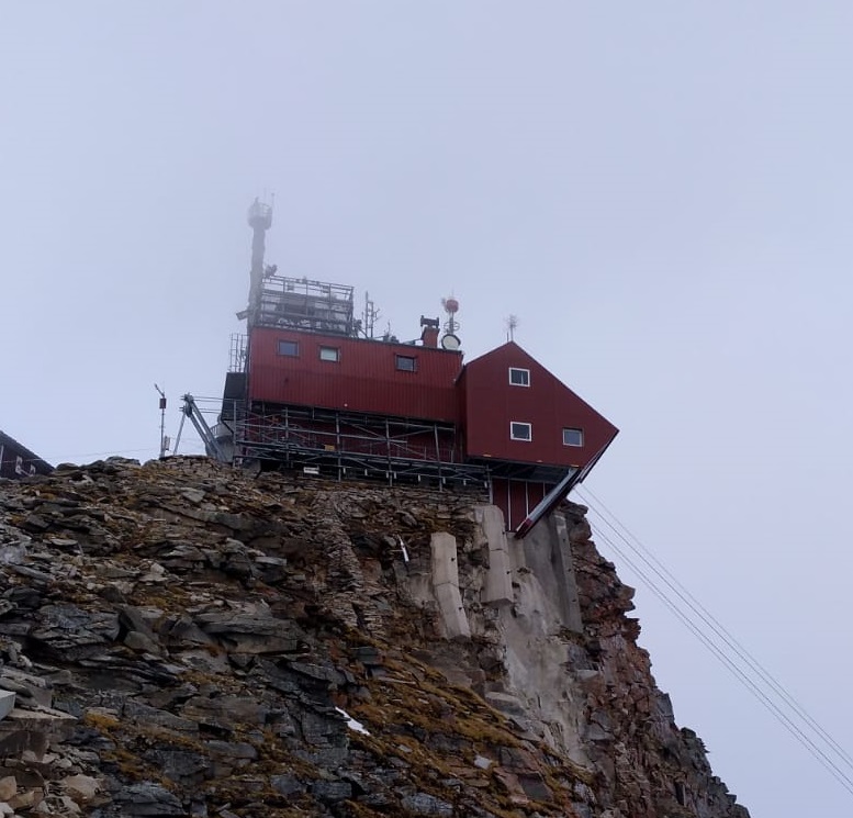
Sonnblick Observatory is located in the Austrian Central Alps at an elevation of 3100 m a.s.l. It is situated at the alpine main divide, which is a clear climatological border. It also lies in the “Nationalpark Hohe Tauern” which covers 1856 km2 of the Austrian Alps at the border between the provinces of Salzburg, Carinthia, and Tyrol. Nearest villages are Heiligenblut to the South (10 km away) and Rauris to the North (20 km away). One important reason for the establishment of the Sonnblick Observatory in 1886 was the available infrastructure from gold mining activities.
Climate data
Grey colours are WMO Climate Normals including maximum and minimum values. Blue colours are individual years.
Climate data for the stations where extracted via Copernicus Climate Data Store, from the global gridded reanalysis product:
ERA5 monthly averaged data on single levels from 1940 to present.
Description and source code: Roemer J.K. 2023. https://doi.org/10.5281/zenodo.10214922
Data Source: Hersbach et al. 2023. Copernicus Climate Change Service (C3S) Climate Data Store (CDS), https://doi.org/10.24381/cds.f17050d7
Biodiversity and natural environment
The natural environment is high-alpine with year-round snow-cover, glaciers, and permafrost. Sonnblick region covers mountain ecosystems.
History and facilities
Sonnblick Observatory was built in 1886 at the summit of Sonnblick Mountain, motivated from the need for information on meteorology in higher altitudes of the atmosphere. Very soon other scientific disciplines became interested in the extreme location of the observatory, e.g. Nobel-prize winner V.F. Hess for his measurements of cosmic rays. In 1986, the observatory was rebuilt to a modern observatory with cable car access, electricity, and a large research platform. From that time onwards investigations on atmospheric chemistry became a new research field at Sonnblick. Today, Sonnblick is a station of interdisciplinary research covering the atmosphere, the cryosphere, the biosphere, the lithosphere, and the hydrosphere.
General research and databases
Research of Sonnblick is currently formulated in the research programme ENVISON. It covers three main topics (the atmosphere, the cryosphere, and the biosphere) in an extensive monitoring programme and with many research projects. Sonnblick is outstanding with respect to its long-term climate observations and studies on glacier changes. Thus, the impact of Climate Change on the cryosphere is a major research topic at Sonnblick. Since 1886, Sonnblick was also involved in many international projects on atmospheric chemistry and atmospheric physics. The research is described on www.sonnblick.net. Sonnblick Observatory cooperates with several Austrian and international universities/research institutions. Within the frame of the GAW-DACH cooperation, Sonnblick has a special partnership with the observatories Jungfraujoch (in Switzerland), Zugspitze and Hohenpeissenberg (both Germany) for common research on atmospheric processes and Climate Change (GAW: Global Atmosphere Watch in Germany, Austria, and Switzerland: D-A-CH).
Link to data: https://dataportal.eu-interact.org/stations
Station Monitoring
-
Climate
- Meteorology
- Energy balance and radiation
-
Geo
- Geology/Geomorphology
- Geophysics and Geodesy
- Sub-surface characteristics
- Snow characteristics
- Atmospheric composition
- Pollution
-
Glacier
- Glacier characteristics
- Mass balace
- Climate
- Glacier hydrology
- Bio-geochemistry of snow, ice and water
- Particles and aerosols
- Pollutants e.g. POPs and heavy metals in snow, ice and water
- Isotope chemistry of snow, ice and water
-
Bio
- Vegetation
- Arthropods
- Birds
- Mammals
- Genetics
- Pollution
- Socio-ecological issues (disturbance)
Human dimension
The nearest settlements are Rauris (c. 30 inhabitants) in the North and Heiligenblut, at the foot of Austria’s highest peak Großglockner (3798 m), in the South. Both villages are well known tourist centres for mountain-related summer and winter activities (all kind of skiing, hiking, climbing, cycling, etc.). The Valley of Rauris is the largest community of the Salzburg province, and has more than 420000 bed-nights related to tourism per year. Heiligenblut has 1090 inhabitants (January 2011) and is the end point of the Großglocker Hochalpenstraße (high alpine road).
Access
Access to Sonnblick Observatory is possible throughout the year either by cable car from the North (20 minutes trip from Rauris valley) or by hiking from Rauris valley from the north or from Heiligenblut from the south (about 5 hours hike from both sides). As Sonnblick is situated within the “Nationalpark Hohe Tauern” the use of helicopters is restricted. However, scientific activities usually will get permission for required helicopter flights. Because of its remote location in the Alps potential mountain hazards have to be considered during field work. Sonnblick Observatory is built together with an alpine hut “Zittelhaus” which offers additional accommodation and space.