Address

M.M. Kłapa Station
Hala Gąsienicowa
34-500 Zakopane
Poland

Station manager

Prof. Zofia Rączkowska
E-mail: raczk@zg.pan.krakow.pl

Contact Station

Phone: +48 12 422 40 85
E-mail: kedzia@zg.pan.krakow.pl

www.igipz.pan.pl/hala-gasienicowa-zbg.html

Station Features

Opening year: 1948 Status: Open
  • Type of station: Station
  • Operational period – year-round or Month A to Month B: Year-round
  • Name of station owner: Institute of Geography and Spatial Organization, Polish Academy of Sciences, Department of Geoenvironmental Research
  • Type of owner: Government
  • Name of managing institution: Institute of Geography and Spatial Organization, Polish Academy of Sciences, Department of Geoenvironmental Research
  • Managing Institution Country: Poland
  • Station owner country: Poland
  • Partner institution: No
  • Station latitude: 49,24421389
  • Station longitude: 20,00566389
  • Country (station location): Poland
  • Altitude of station: 1520 m a.s.l
  • Min. altitude within study area: 800 m a.s.l
  • Max. altitude within study area: 2301 m a.s.l
  • Nearest town/settlement: Zakopane (30 000 inhabitants)
  • Distance to nearest town/settlement: 5 km
  • Number of residents in nearest town: 30000
  • Distance to nearest research station: 346 km
  • Maps available at station: Topograpgical maps (1:10 000), orthophotomaps, aerial ­image, satellite image, Google Earth, DTM
  • Climate zone: Alpine
  • Period of measurments for climate data below [year to year]: Since 1913
  • Mean annual temperature: 2,4 °C
  • Mean temperature in February: -5,8 °C
  • Mean temperature in July: 10,7 °C
  • Precipitation type: Snow, Rain
  • Dominant wind direction: Southwest
  • Mean annual wind speed: 2,5 m/s
  • Maximum wind speed (absolute): 88 m/s
  • Landscape features Mountains, Valleys, Lake, River
  • Permafrost zone Sporadic
  • Snow and ice on land Permanent snow patches
  • Vegetation zone Tree line, Polar desert/Semi-desert, Shrub tundra, Forest tundra, Deciduous forest, Evergreen forest
  • Human use Settlement, Tourism

Facilities

  • Area under roof: 300 m²
  • Max. number of visitors at a time : 4
  • Showers: Yes
  • Laundry facilities: Yes
  • Power supply – period (from ‘hour’ to ‘hour’ or 24 hours): 24
  • Power supply - plug type C, E
  • Logistics area: 150 m²
  • Workshops Metal, Wood
  • Means of transportation to/from station Walk, Other
  • Air transport landing facilities at station Helipad
  • Airstrip (Length × Width) : Airport at Kraków-Balice (130 km)
  • Number of staff peak season/summer: 1
  • Number of staff off season/winter: 1
  • Staff able to assist (workshops): Yes - if time allows
  • Field to station Mobile phone
  • Station to outside world Mobile phone, Internet
  • IT Infrastructure Computers, Printer, Other
  • Medical facilities: Yes
  • Medical capability Basic
  • Distance to hospital (estimated time – hours): 5
  • Laboratory area: 10 m²

Science

  • Transnational Access: Yes
  • Remote Access: No
  • INTERACT Virtual Access: Yes
  • Permitting issues categories
    • Permits required for access to the station
    • Permits required for studies
  • Partner institutions (involved in the operation of the station)
    • Partner institution
  • Climate
    • Snow
    • Rain
    • Hail
  • Housing and accomodation
    • Showers
    • Laundry facilities
    • A
    • B
    • C
    • D
    • E
    • F
    • G
    • H
    • I
    • J
    • K
    • L
    • M
    • N
    • O
    • Municipal grid
    • Diesel/oil/gas
    • Wood
    • Solar
    • Wind
    • Water
    • Geothermal
    • Biofuel
    • Other
  • Logistics
    • Electrical and IT technologies
    • Mechanical
    • Metal
    • Wood
    • Plexiglas
    • Other
    • Walk
    • None
    • Tracked vehicle
    • Truck
    • SUV (4x4)
    • Car
    • ATV
    • Zodiac
    • Snowmobile
    • Open boat/Dhinghy
    • Closed boat
    • Bicycles
    • Amphibie vehicle
    • Ski
    • Other
    • Snow shoes
    • KickSledges
    • Other
    • Ski
    • Snowmobile
    • Boat
    • Car
    • Tracked vehicle
    • Truck
    • SUV (4x4)
    • Bus
    • Train
    • Airstrip
    • Scheduled flight
    • Helipad
    • Chartered plane/helicopter
    • Other
    • None
    • Harbour/port
    • Warf/pier
    • Pontoon/float bridge
    • Barges
    • Beach
  • Aircraft landing facilities
    • Helipad
  • Features in the facility area
    • Permanent snowpatches
    • Mountain
    • Valley
    • Lake
    • River
    • Shoreline
    • Tree line
    • Polar deserts/semi-deserts
    • Shrub tundra
    • Gramminoid tundra
    • Forest tundra
    • Peatlands
    • Wetlands
    • Palsa mires
    • Deciduous forest
    • Evergreen forest
    • Human settlements or resource use in the area
    • Arable land
    • Other
  • Main science disciplines
    • Astronomy
    • Atmospheric sciences
    • Cryology
    • Geology
    • Hydrology
    • Limnic biology
    • Marine biology
    • Terrestrial biology
    • Human biology
    • Anthropology
    • Archaeology
    • Sociology
    • Climate change
    • Environmental science (incl. pollution)
    • Oceanography
    • Agriculture
    • Animal husbandry
    • Fisheries
    • Forestry
    • Hunting
    • Tourism
  • Workshop facilities
    • Metal workshop
    • Wood workshop
    • Plexiglas workshop
    • Staff available to assist with constructions
  • Communication
    • Telephone
    • Satellite phone
    • VHF
    • E-mail
    • Internet
    • Computer
    • Printer
    • Scanner
    • Fax
  • Meteorology
    • Air temperature
    • Air humidity
    • Air pressure
    • Wind velocity
    • Wind direction
    • Precipitation
  • Energy balance and radiation
    • Energy balance
    • Short wave incoming
    • Short wave outgoing
    • Long wave incoming
    • Long wave outgoing
    • Net radiation
    • UV-B
    • Multi-spectral
    • Cloud cover/hours of sunshine
  • Geology/Geomorphology
    • Quaternary geology
    • Sedimentology
    • Bedrock geology
    • Erosion
  • Sub-surface characteristics
    • Ground surface temperature
    • Soil temperature
    • Soil moisture
    • Ground water table
    • Soil water chemistry
    • Active layer depth
    • Permafrost distribution
    • Permafrost thickness
    • Permafrost temperature
  • Snow characteristics
    • Snow depth
    • Snow cover
    • Snow density
    • Snow temperature
  • Hydrology/Limnology
    • River water discharge/water level
    • Lake water level
    • Water balance
    • Water temperature
    • Lake ice cover (formation/breakup/thickness)
    • Suspended sediment discharge
    • Organic matter discharge
    • PAR (Photosyntetically Active Radiation)/secchi depth
    • Water chemistry
  • Vegetation
    • Flowering phenology
    • Amount of flowering
    • NDVI (plot/transect)
    • Landscape NDVI (from satellite images)
    • Vascular plant community composition
    • Bryophyte community composition
    • Lichen community composition
    • Fungi community composition
    • Berry production
    • Aerobiological monitoring (pollen, spores, etc.)
    • Species list (community composition)
  • Lake ecology
    • Phytoplankton (including chlorophyll)
    • Zooplankton
    • Vegetation
    • Fish
    • Invertebrates
    • Species list (community composition)
  • Landscape and environment
    • Mountains
    • Nunataks
    • Volcano/crater
    • Lava fields
    • Plateaus
    • Moraines
    • Valleys
    • Homothermic Springs
    • Lake
    • Thermokarst lake
    • River
    • Delta/estuarie
    • Fjord
    • Continuous
    • Sea
    • Discontinuous
    • Beach
    • Sporadic
    • Rocky shores
    • Pingos/ice lenses
    • Sea cliffs
    • Other (text)
    • Palsa mires
    • Ice Caps
    • None
    • Glaciers
    • Permanent snow patches
    • None
    • Tree line
    • Polar desert/Semi-desert
    • Gramminoid tundra
    • Shrub tundra
    • Forest tundra
    • Wetlands
    • Peatlands/mires
    • Salt marshes/lagoons
    • Heath
    • Grassland
    • Deciduous forest
    • Evergreen forest
    • Terrestrial carnivores
    • Alpine heath
    • Ungulates
    • Hares
    • Other (text)
    • Rodents
    • Bird colonies
    • Polar bear
    • Whales
    • Seals
    • Fish
    • Settlement
    • Fishing
    • Hunting
    • Forestry
    • Agriculture
    • Tourism
    • Animal husbandry
    • Leisure activities
  • Communication and IT
    • Mobile phone
    • VHF
    • Satellite phone
    • Other
    • Satellite phone
    • Mobile phone
    • Internet
    • Other
    • Wireless transfer of data from field site to station
    • Wifi
    • Computers
    • Printer
    • Data storage
    • Statistical tools
    • GIS tools
    • Other
  • Medical facilities
    • Medical facilities
    • Basic
    • Medium
    • Extensive
    • Dental
    • Surgery
    • Other
    • No
    • In peak season
    • When open
  • Laboratory
    • Freezer < -80
    • Freezer -40 - -10
    • Fridge
    • Microscopes
    • Basic laboratory equipment
    • Advanced laboratory equipment
    • Basic chemical reagents
    • Analytical instrumentation
    • Other
    • Laboratory available in nearby town/settlement

Station name and owner

M&M Klapa Research Station is run by the Institute of Geography and Spatial Organization, Polish Academy of Sciences, Department of Geoenvironmental Research.

Location

The station is located in the in Tatra National Park (Tatra Mountains), in the Hala Gasienicowa area (49°15’ N, 20°00’ E). The station is located 1520 m a.s.l. at the upper timberline and the lower limit of the periglacial zone. The highest summit in the area reaches 2301 m a.s.l.

Climate data

Grey colours are WMO Climate Normals including maximum and minimum values. Blue colours are individual years.

Climate data for the stations where extracted via Copernicus Climate Data Store, from the global gridded reanalysis product: ERA5 monthly averaged data on single levels from 1940 to present. Description and source code: Roemer J.K. 2023. https://doi.org/10.5281/zenodo.10214922 Data Source: Hersbach et al. 2023. Copernicus Climate Change Service (C3S) Climate Data Store (CDS), https://doi.org/10.24381/cds.f17050d7

Biodiversity and natural environment

The station is situated in a high-mountain environment with an alpine landscape. The mean annual temperature is 2.4 °C, and the mean annual precipitation is 1666 mm (varying from 1043 mm to 2626 mm). The vegetation varies from coniferous forest in the forest zone, trough Pinus mugo shrubs in the sub-alpine zone, alpine meadows in the alpine zone, and bare rocks in sub-nival zone.

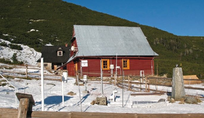
History and facilities

Research started in December 1913, when the first meteorological measurements were made. The more complex environmental research was initiated by the Association of Polish Geographers in 1948. In the beginning, the station mainly carried out basic climatic and nival measurements. In 1953, the station became part of the Institute of Geography and Spatial Organization, Polish Academy of Sciences. Since then, the focus of research has also been on geomorphology, climatology, and biogeography. The station is a wooden house. The building has central heating, running water, electric power, and internet. The station has three rooms, i.e. a kitchen, a pantry, a bathroom, and different storage rooms.

General research and databases

The station constitutes a convenient base for geomorphological, climatic and geo-botanic investigations due to its highly favourable location. Geomorphological studies focus on landscape development. At present, the studies concentrate on monitoring of landscape change due to climate change. Climatic studies focus on micro-climatic and topo-climatic issues. Studies on vegetation deal with mapping at various scales and with dynamics of changes in vegetation. Meteorological observations are carried out by the Institute of Meteorology and Water Management, and long-term data are available.

Link to data: https://dataportal.eu-interact.org/stations

Station Monitoring

Human dimension

The station is open to national and international scientists. It can accommodate 4-6 scientists at a time. The nearest inhabited place, i.e. the mountain resort Zakopane, is within 2-3 hours walking distance from the station. The town, Zakopane, has a population of c. 30000 inhabitants.

Access

The station is situated c. 100 km away from the Kraków-Balice Airport and c. 5 km away from the railway and bus stations in Zakopane. Access to the station is by foot. However, transport of heavy equipment is possible by car. Travel time from the Kraków–Balice airport is around half day.

Member of: