Address

UIC Science, LLC
NARL Bldg 848/ Barrow Arctic Research Center
P.O. Box 936
Utqiaġvik, AK 99723
USA

Station manager

Terri Mitchell
E-mail: Terri.Mitchell@UICCS.com

Contact Station

Phone: 907-632-1240
E-mail: lindsay.cameron@uiccs.com

https://uicalaska.com/our-companies/uic-commercial-services/uic-science-llc/

Station Features

Opening year: 1992 Status: Open
  • Type of station: Station
  • Operational period – year-round or Month A to Month B: Year-round
  • Name of station owner: Ukpeaġvik Iñupiat Corporation
  • Type of owner: NGO
  • Name of managing institution: Lindsay Cameron
  • Managing Institution Country: United States
  • Station owner country: United States
  • Partner institution: No
  • Station latitude: 71,32495278
  • Station longitude: -156,66741111
  • Country (station location): United States
  • Altitude of station: 5 m a.s.l
  • Min. altitude within study area: 0 m a.s.l
  • Max. altitude within study area: 10 m a.s.l
  • Nearest town/settlement: Barrow
  • Distance to nearest town/settlement: 5 km
  • Number of residents in nearest town: 4500
  • Distance to nearest research station: 404 km
  • Maps available at station:
  • Climate zone: High Arctic
  • Period of measurments for climate data below [year to year]: Since 1947
  • Mean annual temperature: -12,6 °C
  • Mean temperature in February: -27,7 °C
  • Mean temperature in July: 4,1 °C
  • Precipitation type: Snow, Rain
  • Sea ice break up: July
  • Lake ice break up: June
  • Dominant wind direction: East
  • Mean annual wind speed: 6 m/s
  • Maximum wind speed (absolute): 35 m/s
  • Landscape features Lake, Delta/estuarie, Sea
  • Permafrost zone Continuous
  • Vegetation zone Polar desert/Semi-desert, Gramminoid tundra, Wetlands
  • Wildlife Polar bear, Whales, Seals
  • Human use Settlement, Hunting

Facilities

  • Area under roof: 2500 m²
  • Max. number of visitors at a time : 75
  • Showers: Yes
  • Laundry facilities: Yes
  • Power supply – period (from ‘hour’ to ‘hour’ or 24 hours): 24 Hours
  • Power supply - plug type A, B
  • Logistics area: 1400 m²
  • Workshops Metal, Wood
  • Means of transportation to/from station Truck
  • Air transport landing facilities at station Airstrip, Helipad
  • Airstrip (Length × Width) : 2164 × 46 m
  • Airstrip surface : Tarmac/Concrete
  • Transport on land - at station ATV, Snowmobile, Car, Other
  • Transport on water - at station Zodiac, Open boat/Dhinghy
  • Number of staff peak season/summer: 12
  • Number of staff off season/winter: 10
  • Staff able to assist (fieldwork): Yes - if time allows
  • Staff able to assist (workshops): Yes - if time allows
  • Compulsory safety equipment VHF
  • Recommended safety equipment Bearspray
  • Field power supply available at station: Yes
  • Field to station Mobile phone, VHF
  • Station to outside world Mobile phone, Internet
  • IT Infrastructure Computers, Printer
  • Medical facilities: Yes
  • Medical capability Extensive
  • Distance to hospital (estimated time – hours): 0

Science

  • Transnational Access: Yes
  • Remote Access: Yes
  • INTERACT Virtual Access: No
  • Permitting issues categories
    • Permits required for access to the station
    • Permits required for studies
  • Partner institutions (involved in the operation of the station)
    • Partner institution
  • Climate
    • Snow
    • Rain
    • Hail
  • Housing and accomodation
    • Showers
    • Laundry facilities
    • A
    • B
    • C
    • D
    • E
    • F
    • G
    • H
    • I
    • J
    • K
    • L
    • M
    • N
    • O
    • Municipal grid
    • Diesel/oil/gas
    • Wood
    • Solar
    • Wind
    • Water
    • Geothermal
    • Biofuel
    • Other
  • Logistics
    • Electrical and IT technologies
    • Mechanical
    • Metal
    • Wood
    • Plexiglas
    • Other
    • Walk
    • None
    • Tracked vehicle
    • Truck
    • SUV (4x4)
    • Car
    • ATV
    • Zodiac
    • Snowmobile
    • Open boat/Dhinghy
    • Closed boat
    • Bicycles
    • Amphibie vehicle
    • Ski
    • Other
    • Snow shoes
    • KickSledges
    • Other
    • Ski
    • Snowmobile
    • Boat
    • Car
    • Tracked vehicle
    • Truck
    • SUV (4x4)
    • Bus
    • Train
    • Airstrip
    • Scheduled flight
    • Helipad
    • Chartered plane/helicopter
    • Other
    • None
    • Harbour/port
    • Warf/pier
    • Pontoon/float bridge
    • Barges
    • Beach
  • Aircraft landing facilities
    • Helipad
  • Features in the facility area
    • Permanent snowpatches
    • Mountain
    • Valley
    • Lake
    • River
    • Shoreline
    • Tree line
    • Polar deserts/semi-deserts
    • Shrub tundra
    • Gramminoid tundra
    • Forest tundra
    • Peatlands
    • Wetlands
    • Palsa mires
    • Deciduous forest
    • Evergreen forest
    • Human settlements or resource use in the area
    • Arable land
    • Other
  • Main science disciplines
    • Astronomy
    • Atmospheric sciences
    • Cryology
    • Geology
    • Hydrology
    • Limnic biology
    • Marine biology
    • Terrestrial biology
    • Human biology
    • Anthropology
    • Archaeology
    • Sociology
    • Climate change
    • Environmental science (incl. pollution)
    • Oceanography
    • Agriculture
    • Animal husbandry
    • Fisheries
    • Forestry
    • Hunting
    • Tourism
  • Workshop facilities
    • Metal workshop
    • Wood workshop
    • Plexiglas workshop
    • Staff available to assist with constructions
  • Communication
    • Telephone
    • Satellite phone
    • VHF
    • E-mail
    • Internet
    • Computer
    • Printer
    • Scanner
    • Fax
  • Meteorology
    • Air temperature
    • Air humidity
    • Air pressure
    • Wind velocity
    • Wind direction
    • Precipitation
  • Energy balance and radiation
    • Energy balance
    • Short wave incoming
    • Short wave outgoing
    • Long wave incoming
    • Long wave outgoing
    • Net radiation
    • UV-B
    • Multi-spectral
    • Cloud cover/hours of sunshine
  • Sub-surface characteristics
    • Ground surface temperature
    • Soil temperature
    • Soil moisture
    • Ground water table
    • Soil water chemistry
    • Active layer depth
    • Permafrost distribution
    • Permafrost thickness
    • Permafrost temperature
  • Snow characteristics
    • Snow depth
    • Snow cover
    • Snow density
    • Snow temperature
  • Atmospheric composition
    • CO<sub>2</sub> concentration
    • CH<sub>4</sub> concentration
  • Greenhouse gas exchange
    • CO<sub>2</sub> exchange
    • CH<sub>4</sub> exchange
    • N<sub>2</sub>O exchange
  • Energy budget
    • Net radiation
    • Sensible heat flux
    • Latent heat flux
    • Soil heat flux
  • Hydrology/Limnology
    • River water discharge/water level
    • Lake water level
    • Water balance
    • Water temperature
    • Lake ice cover (formation/breakup/thickness)
    • Suspended sediment discharge
    • Organic matter discharge
    • PAR (Photosyntetically Active Radiation)/secchi depth
    • Water chemistry
  • Pollution
    • In air
    • In water
    • In soil
    • In snow/ice
    • Contaminants in species
  • Vegetation
    • Flowering phenology
    • Amount of flowering
    • NDVI (plot/transect)
    • Landscape NDVI (from satellite images)
    • Vascular plant community composition
    • Bryophyte community composition
    • Lichen community composition
    • Fungi community composition
    • Berry production
    • Aerobiological monitoring (pollen, spores, etc.)
    • Species list (community composition)
  • Birds
    • Abundance
    • Distribution
    • Phenology
    • Breeding birds
    • Nest initiation phenology
    • Nest predation rates
    • Species list (community composition)
  • Mammals
    • Mammal abundance
    • Mammal distribution
    • Mammal reproduction
    • Mortality
    • Predation
    • Physiology
    • Species list (community composition)
  • Lake ecology
    • Phytoplankton (including chlorophyll)
    • Zooplankton
    • Vegetation
    • Fish
    • Invertebrates
    • Species list (community composition)
  • Genetics
    • Collection of genetic material
  • Diseases
    • Mammals
    • Birds
    • Fish
    • Vegetation
    • Other
  • Socio-ecological issues (disturbance)
    • Number of visitors
    • Surface activities (e.g. removal of vegetation, organisms, soil samples, ATV traffic, manipulations)
    • Aircraft activities
    • Emissions/discharge energy consumption, spill water, waste, garbage, atmospheric emissions, etc.)
  • Landscape and environment
    • Mountains
    • Nunataks
    • Volcano/crater
    • Lava fields
    • Plateaus
    • Moraines
    • Valleys
    • Homothermic Springs
    • Lake
    • Thermokarst lake
    • River
    • Delta/estuarie
    • Fjord
    • Sea
    • Continuous
    • Discontinuous
    • Beach
    • Sporadic
    • Rocky shores
    • Pingos/ice lenses
    • Sea cliffs
    • Other (text)
    • Palsa mires
    • None
    • Ice Caps
    • Glaciers
    • Permanent snow patches
    • None
    • Tree line
    • Polar desert/Semi-desert
    • Gramminoid tundra
    • Shrub tundra
    • Forest tundra
    • Wetlands
    • Peatlands/mires
    • Salt marshes/lagoons
    • Heath
    • Grassland
    • Deciduous forest
    • Terrestrial carnivores
    • Evergreen forest
    • Alpine heath
    • Ungulates
    • Hares
    • Other (text)
    • Rodents
    • Bird colonies
    • Polar bear
    • Whales
    • Seals
    • Fish
    • Settlement
    • Fishing
    • Hunting
    • Forestry
    • Agriculture
    • Tourism
    • Animal husbandry
    • Leisure activities
  • Field equipment
    • PLB
    • VHF
    • HF
    • Satellite phone
    • Mobile phone
    • GPS
    • Weapon/rifle
    • Flare gun
    • Bearspray
    • PLB
    • First aid kit
    • Glacier rescue kit
    • VHF
    • Avalanche rescue kit
    • HF
    • Satellite phone
    • Overnight equipment
    • Other
    • Mobile phone
    • GPS
    • Weapon/rifle
    • Flare gun
    • Bearspray
    • PLB
    • First aid kit
    • Glacier rescue kit
    • VHF
    • Avalanche rescue kit
    • HF
    • Satellite phone
    • Overnight equipment
    • Other
    • Mobile phone
    • GPS
    • Weapon/rifle
    • Flare gun
    • Bearspray
    • Tent
    • First aid kit
    • Glacier rescue kit
    • Sleeping matress
    • Avalanche rescue kit
    • Sleeping bag
    • Cooking equipment and utensils
    • Overnight equipment
    • Other
    • Gas/alcohol for cooking
    • Field power supply available at station
  • Communication and IT
    • Mobile phone
    • VHF
    • Satellite phone
    • Other
    • Satellite phone
    • Mobile phone
    • Internet
    • Other
    • Wireless transfer of data from field site to station
    • Wifi
    • Computers
    • Printer
    • Data storage
    • Statistical tools
    • GIS tools
    • Other
  • Medical facilities
    • Medical facilities
    • Basic
    • Medium
    • Extensive
    • Dental
    • Surgery
    • Other
    • No
    • In peak season
    • When open

Station name and owner

The Barrow Arctic Research Center and Barrow Environmental Observatory are managed by UIC Science, a business unit of the Ukpeavik I&ntilde;upiat Corporation.

Location

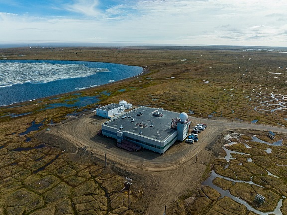
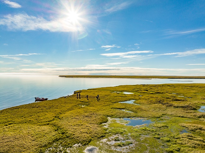
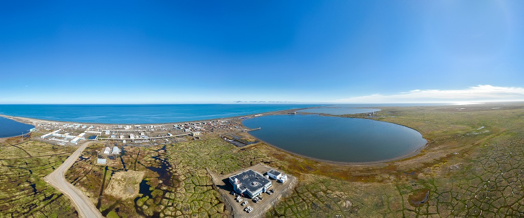
Utqiaġvik (formerly Barrow) (c. 4000 inhabitants) is located at the northern tip of Alaska (USA) on the Arctic Coastal Plain north of the Brooks Range Mountains, at the junction of the Chukchi and Beaufort Seas. The adjacent Barrow Environmental Observatory comprises 30.21 km2 of tundra, lakes, and wetlands reserved for scientific research including long-term environmental monitoring and habitat manipulation experiments.

Climate data

Grey colours are WMO Climate Normals including maximum and minimum values. Blue colours are individual years.

Climate data for the stations where extracted via Copernicus Climate Data Store, from the global gridded reanalysis product: ERA5 monthly averaged data on single levels from 1940 to present. Description and source code: Roemer J.K. 2023. https://doi.org/10.5281/zenodo.10214922 Data Source: Hersbach et al. 2023. Copernicus Climate Change Service (C3S) Climate Data Store (CDS), https://doi.org/10.24381/cds.f17050d7

Biodiversity and natural environment

Utqiaġvik (formerly known as Barrow) is characterized by a polar maritime climate but is semi-arid (c. 150 mm annual precipitation). It lies north of the tree-line so the dominant vegetation types are grass, moss, and sedge. Virtually all land in the area is underlain by permafrost within a few meters of the surface. The landscape is characterized by thermokarst lakes and drained lake basins undergoing plant succession. Polar bears and Arctic foxes are found in the region. A large number of transient bird species migrate to the North Slope during the summer including snowy owl, tundra swan, snow bunting, and various species of geese and ducks, including the endangered Steller’s and spectacled eiders. Caribou are frequently observed in the area. During the spring, bowhead whales migrate close to shore, and both gray and beluga whales are often sighted during the summer.

History and facilities

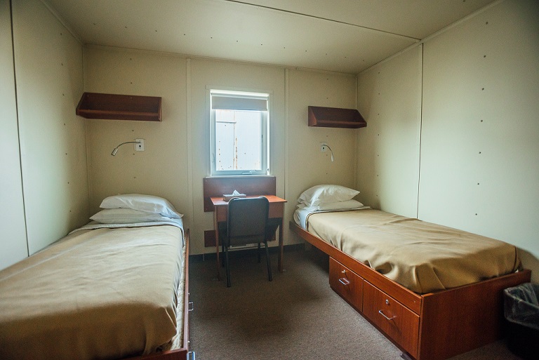
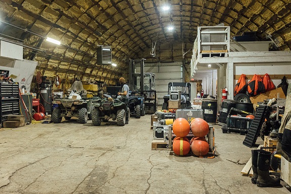
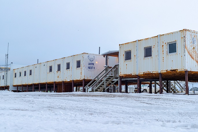
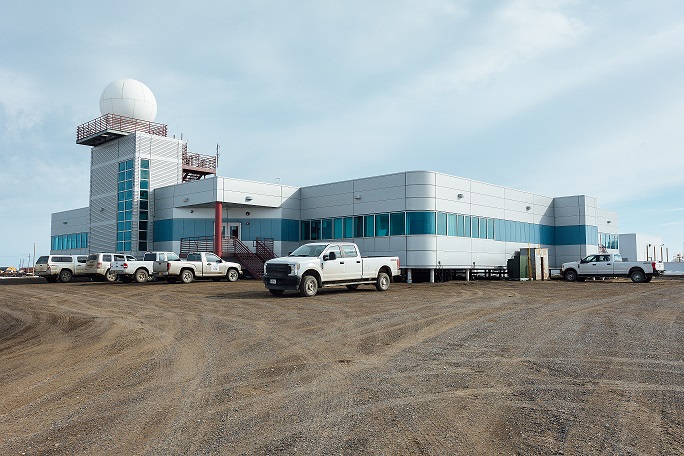
Utqiaġvik (formerly known as Barrow) has a long research history starting with the establishment of an observation station during the First International Polar Year (1882-1883) – hosting near-continuous measurements since then. The Arctic Research Laboratory was established in 1947 and has supported a vast number of atmospheric, biological, oceanic, and terrestrial research activities. Present facilities include modern laboratories, storage, internet access, local accommodations, and cafeteria or self-catering facilities. Vehicle support can also be arranged. Restaurants, supplies, and a grocery store are available in town. Several other programs funded through the US government maintain additional facilities in Utqiaġvik including the National Weather Service and Earth System Research Laboratory (both part of the National Oceanic and Atmospheric Admin.), Atmospheric Radiation Measurement Climate Research Facility (Dept. of Energy), and the US Fish and Wildlife Service (Dept. of Interior). Additionally, the North Slope Borough Department of Wildlife Management is based in Utqiaġvik.

General research and databases

Approximately 50 individual research projects are supported annually. Much of the work at Utqiaġvik involves atmospheric chemistry, ecosystem dynamics, plant/animal phenology studies, and Climate Change monitoring. Many sea ice studies are also based in the area. Limnological and large animal physiology projects are occasionally undertaken.

Station Monitoring

Human dimension

Utqiaġvik has been occupied by humans for at least 1200 years, and a strong Iñupiaq culture is still practiced today including subsistence hunting and whaling activities. English is the predominant language but many residents speak Iñupiaq. The village is the political, logistical, and administrative hub of the 245000 km2 North Slope Borough, and as a result most modern conveniences are available. Summer tourism is an important part of the economy, and nearby resource extraction is becoming more prevalent. Several mobile phone carriers provide reliable service. Off-road access to the tundra (i.e. for hiking) requires a local land use permit. There are several gymnasiums open to the public and Barrow High School provides opportunities for spectator sports. The local Tribal College, IḷisaġvikCollege, provides continuing education and vocational training to students throughout the region.

Access

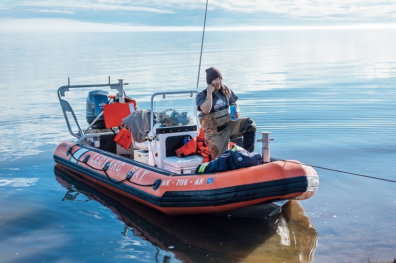
There is no road access to Utqiaġvik, but the town is serviced by commercial airlines (Alaska Airlines and Wright Air) with daily flights, year-round. Both fixed-wing aircrafts and helicopters can be chartered for research activities from vendors based in Fairbanks (800 km away) or Anchorage (1200 km away) and staged from the Utqiaġvik Airport. Additionally, Northern Air Cargo provides commercial shipping services and the US Postal Service delivers mail and small packages daily. There is no port facility, but resupply barges and boat access are available during the summer. Research facilities are located approximately 5 km north of the village and can be reached via the local road system.

Member of: