Address

Toolik Field Station
IAB Toolik 757005
1038 Toklat Way

Fairbanks, AK 99775-7005
US

Station manager

Syndonia Bret-Harte
E-mail: msbretharte@alaska.edu

Contact Station


http://toolik.alaska.edu

Station Features

Opening year: 1975 Status: Open
  • Type of station: Station
  • Operational period – year-round or Month A to Month B: Year-round
  • Name of station owner: Institute of Arctic Biology
  • Type of owner: Government
  • Name of managing institution: Institute of Arctic Biology, University of Alaska Fairbanks
  • Managing Institution Country: United States
  • Station owner country: United States
  • Partner institution: No
  • Station latitude: 68,62777778
  • Station longitude: -149,59472222
  • Country (station location): United States
  • Altitude of station: 720 m a.s.l
  • Min. altitude within study area: 0 m a.s.l
  • Max. altitude within study area: 0 m a.s.l
  • Nearest town/settlement: Deadhorse
  • Distance to nearest town/settlement: 210 km
  • Number of residents in nearest town: 50
  • Distance to nearest research station: 404 km
  • Maps available at station: Maps (1:2000 - 1:25 000), aerial images, satellite images, Google Earth shape files
  • Climate zone: Low Arctic
  • Period of measurments for climate data below [year to year]: Since 1988
  • Mean annual temperature: -8,7 °C
  • Mean temperature in February: -20,7 °C
  • Mean temperature in July: 10,8 °C
  • Precipitation type: Snow, Rain
  • Lake ice break up: July
  • Dominant wind direction: South
  • Mean annual wind speed: 3,1 m/s
  • Maximum wind speed (absolute): 23,6 m/s
  • Landscape features Mountains, Valleys, Lake, River
  • Permafrost zone Continuous
  • Vegetation zone Shrub tundra, Gramminoid tundra, Peatlands, Wetlands, Peatlands/mires

Facilities

  • Area under roof: 5546 m²
  • Max. number of visitors at a time : 150
  • Showers: Yes
  • Laundry facilities: Yes
  • Power supply – period (from ‘hour’ to ‘hour’ or 24 hours): 24 Hours
  • Power supply - plug type A, B
  • Power sources at station Diesel/oil/gas
  • Logistics area: 4095 m²
  • Workshops Electrical and IT technologies, Mechanical, Metal, Plexiglas, Wood
  • Means of transportation to/from station Car
  • Airstrip (Length × Width) : 1595 × 46 m, Galbraith Lake approx. 33 km from station
  • Airstrip surface : Gravel/Sand
  • Transport on land - at station Snowmobile, Car
  • Number of staff peak season/summer: 19
  • Number of staff off season/winter: 3
  • Staff able to assist (workshops): Yes - if time allows
  • Recommended safety equipment Satellite phone
  • Laboratory area: 1452 m²
  • Field to station Mobile phone, VHF, Satellite phone
  • Station to outside world Mobile phone, Internet
  • IT Infrastructure Wifi, Computers, Printer
  • Medical capability Medium
  • Staff with medical training/doctor In peak season, When open
  • Distance to hospital (estimated time – hours): 220

Science

  • Transnational Access: Yes
  • Remote Access: Yes
  • INTERACT Virtual Access: Yes
  • Permitting issues categories
    • Permits required for access to the station
    • Permits required for studies
  • Partner institutions (involved in the operation of the station)
    • Partner institution
  • Climate
    • Snow
    • Rain
    • Hail
  • Housing and accomodation
    • Showers
    • Laundry facilities
    • A
    • B
    • C
    • D
    • E
    • F
    • G
    • H
    • I
    • J
    • K
    • L
    • M
    • N
    • O
    • Municipal grid
    • Diesel/oil/gas
    • Wood
    • Solar
    • Wind
    • Water
    • Geothermal
    • Biofuel
    • Other
  • Logistics
    • Electrical and IT technologies
    • Mechanical
    • Metal
    • Wood
    • Plexiglas
    • Other
    • Walk
    • None
    • Tracked vehicle
    • Truck
    • SUV (4x4)
    • Car
    • ATV
    • Zodiac
    • Snowmobile
    • Open boat/Dhinghy
    • Closed boat
    • Bicycles
    • Amphibie vehicle
    • Ski
    • Other
    • Snow shoes
    • KickSledges
    • Other
    • Ski
    • Snowmobile
    • Boat
    • Car
    • Tracked vehicle
    • Truck
    • SUV (4x4)
    • Bus
    • Train
    • Airstrip
    • Scheduled flight
    • Chartered plane/helicopter
    • Helipad
    • Other
    • None
    • Harbour/port
    • Warf/pier
    • Pontoon/float bridge
    • Barges
    • Beach
  • Aircraft landing facilities
    • Helipad
  • Features in the facility area
    • Permanent snowpatches
    • Mountain
    • Valley
    • Lake
    • River
    • Shoreline
    • Tree line
    • Polar deserts/semi-deserts
    • Shrub tundra
    • Gramminoid tundra
    • Forest tundra
    • Peatlands
    • Wetlands
    • Palsa mires
    • Deciduous forest
    • Evergreen forest
    • Human settlements or resource use in the area
    • Arable land
    • Other
  • Main science disciplines
    • Astronomy
    • Atmospheric sciences
    • Cryology
    • Geology
    • Hydrology
    • Limnic biology
    • Marine biology
    • Terrestrial biology
    • Human biology
    • Anthropology
    • Archaeology
    • Sociology
    • Climate change
    • Environmental science (incl. pollution)
    • Oceanography
    • Agriculture
    • Animal husbandry
    • Fisheries
    • Forestry
    • Hunting
    • Tourism
  • Workshop facilities
    • Metal workshop
    • Wood workshop
    • Plexiglas workshop
    • Staff available to assist with constructions
  • Communication
    • Telephone
    • Satellite phone
    • VHF
    • E-mail
    • Internet
    • Computer
    • Printer
    • Scanner
    • Fax
  • Landscape and environment
    • Mountains
    • Nunataks
    • Volcano/crater
    • Lava fields
    • Plateaus
    • Moraines
    • Valleys
    • Homothermic Springs
    • Lake
    • Thermokarst lake
    • River
    • Delta/estuarie
    • Fjord
    • Continuous
    • Sea
    • Discontinuous
    • Beach
    • Sporadic
    • Rocky shores
    • Pingos/ice lenses
    • Sea cliffs
    • Other (text)
    • Palsa mires
    • None
    • Ice Caps
    • Glaciers
    • Permanent snow patches
    • None
    • Tree line
    • Polar desert/Semi-desert
    • Gramminoid tundra
    • Shrub tundra
    • Forest tundra
    • Wetlands
    • Peatlands/mires
    • Salt marshes/lagoons
    • Heath
    • Grassland
    • Deciduous forest
    • Evergreen forest
    • Terrestrial carnivores
    • Alpine heath
    • Ungulates
    • Hares
    • Other (text)
    • Rodents
    • Bird colonies
    • Polar bear
    • Whales
    • Seals
    • Fish
    • Settlement
    • Fishing
    • Hunting
    • Forestry
    • Agriculture
    • Tourism
    • Animal husbandry
    • Leisure activities
  • Field equipment
    • PLB
    • VHF
    • HF
    • Satellite phone
    • Mobile phone
    • GPS
    • Weapon/rifle
    • Flare gun
    • Bearspray
    • PLB
    • First aid kit
    • Glacier rescue kit
    • VHF
    • Avalanche rescue kit
    • HF
    • Satellite phone
    • Overnight equipment
    • Other
    • Mobile phone
    • GPS
    • Weapon/rifle
    • Flare gun
    • Bearspray
    • PLB
    • First aid kit
    • Glacier rescue kit
    • VHF
    • Avalanche rescue kit
    • HF
    • Satellite phone
    • Overnight equipment
    • Other
    • Mobile phone
    • GPS
    • Weapon/rifle
    • Flare gun
    • Bearspray
    • Tent
    • First aid kit
    • Glacier rescue kit
    • Sleeping matress
    • Avalanche rescue kit
    • Sleeping bag
    • Cooking equipment and utensils
    • Overnight equipment
    • Other
    • Gas/alcohol for cooking
    • Field power supply available at station
  • Laboratory
    • Freezer < -80
    • Freezer -40 - -10
    • Fridge
    • Microscopes
    • Basic laboratory equipment
    • Advanced laboratory equipment
    • Basic chemical reagents
    • Analytical instrumentation
    • Other
    • Laboratory available in nearby town/settlement
  • Communication and IT
    • Mobile phone
    • VHF
    • Satellite phone
    • Other
    • Satellite phone
    • Mobile phone
    • Internet
    • Other
    • Wireless transfer of data from field site to station
    • Wifi
    • Computers
    • Printer
    • Data storage
    • Statistical tools
    • GIS tools
    • Other
  • Medical facilities
    • Medical facilities
    • Basic
    • Medium
    • Extensive
    • Dental
    • Surgery
    • Other
    • No
    • In peak season
    • When open

Station name and owner

The Toolik Field Station (TFS) is operated and managed by the Institute of Arctic Biology at the University of Alaska Fairbanks (UAF) with cooperative agreement support from the Division of Polar Programs, Directorate for Geosciences at the US National Science Foundation (NSF).

Location

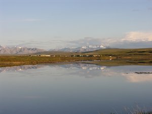
TFS is located 210 km south of Deadhorse and 600 km north of Fairbanks in arctic Alaska. The field station is situated north of Gates of the Arctic National Park, and its location allows scientists to access the Brooks Range, the arctic foothills and the arctic coastal plain.

Climate data

Grey colours are WMO Climate Normals including maximum and minimum values. Blue colours are individual years.

Climate data for the stations where extracted via Copernicus Climate Data Store, from the global gridded reanalysis product: ERA5 monthly averaged data on single levels from 1940 to present. Description and source code: Roemer J.K. 2023. https://doi.org/10.5281/zenodo.10214922 Data Source: Hersbach et al. 2023. Copernicus Climate Change Service (C3S) Climate Data Store (CDS), https://doi.org/10.24381/cds.f17050d7

Biodiversity and natural environment

TFS is situated in the arctic foothills province of the North Slope, which is characterised by rolling hills and broad valleys underlain by continuous permafrost. The area is dotted with lakes, and the vegetation is dominated by dwarf-shrub and tussock tundra. Caribou and Arctic ground squirrels are frequently observed at the field station, and moose, musk-oxen, and grizzly bears are encountered occasionally.

History and facilities

TFS was first established in 1975 to support an aquatic research program. The field station evolved from a 10-person tent camp into a premier arctic research laboratory and science support facility capable of supporting up to 150 researchers. The field station includes several laboratory trailers and tents, a lecture hall, various dormitory accommodation styles, a kitchen and dining hall, shower and laundry facilities, and a tool shop. TFS is open year-round and provides transportation to and from the station, basic science support, high-speed internet, GIS services, general-use laboratory and field equipment, herbarium, and baseline environmental and meteorological data.

General research and databases

Research themes at TFS are wide-ranging and dynamic and currently include the structure and function of terrestrial and aquatic ecosystems of the arctic foothills and tundra, the effects of Climate Change in these regions, and the feedbacks to global Climate Change through gas and hydrological fluxes. TFS-based research has also led to significant discoveries on the adaptations of plants and animals to the Arctic and to population-level changes in phenologies and distributions. Existing databases hosted at TFS include climate records and baseline environmental monitoring. A substantial body of research data collected by the arctic LTER program are also available from their website.

Link to data: https://dataportal.eu-interact.org/stations

Station Monitoring

Human dimension

TFS is located in the North Slope Borough of northern Alaska close to the Dalton High-way. Anaktuvuk is the closest native village, which is situated in the Brooks Range about 150 km west of TFS by air.

Access

TFS is accessible by road from Deadhorse and Fairbanks. The field station provides transportation to and from these towns, and snowmobiles, boats, trucks, and bicycles are available for local transportation. A helicopter scheduled through the National Science Foundation is based at TFS.

Member of: