Address

Kluane Lake Research Station
Mile 1054 Alaska Highway
Yukon Y0B 1H0
Canada

Station manager

Maribeth Murray
E-mail: murraym@ucalgary.ca

Station Features

Opening year: 1961 Status: Open
  • Type of station: Station
  • Operational period – year-round or Month A to Month B: April-September, (October- March)
  • Name of station owner: Arctic Institute of North America
  • Type of owner: Research institution
  • Name of managing institution: Sian Williams, Lance Goodwin
  • Managing Institution Country: Canada
  • Station owner country: Canada
  • Partner institution: No
  • Station latitude: 61,02738889
  • Station longitude: -138,41072222
  • Country (station location): Canada
  • Altitude of station: 793 m a.s.l
  • Min. altitude within study area: 790 m a.s.l
  • Max. altitude within study area: 5959 m a.s.l
  • Nearest town/settlement: Haines Jct.
  • Distance to nearest town/settlement: 65 km
  • Number of residents in nearest town: 800
  • Distance to nearest research station: 850 km
  • Maps available at station: Map (1:50 000 ), aerial image, satellite image, Google Earth with high resolution
  • Climate zone: Sub-Arctic
  • Climate zone: Alpine
  • Climate zone: Boreal
  • Period of measurments for climate data below [year to year]:
  • Mean temperature in February: 0 °C
  • Mean temperature in July: 0 °C
  • Precipitation type: Snow, rain
  • Mean annual wind speed: 0 m/s
  • Maximum wind speed (absolute): 0 m/s

Facilities

  • Area under roof: 1100 m²
  • Max. number of visitors at a time : 30
  • Showers: Yes
  • Laundry facilities: Yes
  • Airstrip (Length × Width) : 1000 × 30 m (Lake: yes)

Science

  • Transnational Access: Yes
  • Remote Access: No
  • INTERACT Virtual Access: Yes
  • Permitting issues categories
    • Permits required for access to the station
    • Permits required for studies
  • Partner institutions (involved in the operation of the station)
    • Partner institution
  • Climate
    • Snow
    • Rain
    • Hail
  • Housing and accomodation
    • Showers
    • Laundry facilities
    • A
    • B
    • C
    • D
    • E
    • F
    • G
    • H
    • I
    • J
    • K
    • L
    • M
    • N
    • O
    • Municipal grid
    • Diesel/oil/gas
    • Wood
    • Solar
    • Wind
    • Water
    • Geothermal
    • Biofuel
    • Other
  • Logistics
    • Electrical and IT technologies
    • Mechanical
    • Metal
    • Wood
    • Plexiglas
    • Other
    • Walk
    • None
    • Tracked vehicle
    • Truck
    • SUV (4x4)
    • Car
    • ATV
    • Zodiac
    • Snowmobile
    • Open boat/Dhinghy
    • Closed boat
    • Bicycles
    • Amphibie vehicle
    • Ski
    • Other
    • Snow shoes
    • KickSledges
    • Other
    • Ski
    • Snowmobile
    • Boat
    • Car
    • Tracked vehicle
    • Truck
    • SUV (4x4)
    • Bus
    • Train
    • Airstrip
    • Scheduled flight
    • Chartered plane/helicopter
    • Helipad
    • Other
    • None
    • Harbour/port
    • Warf/pier
    • Pontoon/float bridge
    • Barges
    • Beach
  • Aircraft landing facilities
    • Helipad
  • Features in the facility area
    • Permanent snowpatches
    • Mountain
    • Valley
    • Lake
    • River
    • Shoreline
    • Tree line
    • Polar deserts/semi-deserts
    • Shrub tundra
    • Gramminoid tundra
    • Forest tundra
    • Peatlands
    • Wetlands
    • Palsa mires
    • Deciduous forest
    • Evergreen forest
    • Human settlements or resource use in the area
    • Arable land
    • Other
  • Main science disciplines
    • Astronomy
    • Atmospheric sciences
    • Cryology
    • Geology
    • Hydrology
    • Limnic biology
    • Marine biology
    • Terrestrial biology
    • Human biology
    • Anthropology
    • Archaeology
    • Sociology
    • Climate change
    • Environmental science (incl. pollution)
    • Oceanography
    • Agriculture
    • Animal husbandry
    • Fisheries
    • Forestry
    • Hunting
    • Tourism
  • Workshop facilities
    • Metal workshop
    • Wood workshop
    • Plexiglas workshop
    • Staff available to assist with constructions
  • Communication
    • Telephone
    • Satellite phone
    • VHF
    • E-mail
    • Internet
    • Computer
    • Printer
    • Scanner
    • Fax
  • Meteorology
    • Air temperature
    • Air humidity
    • Air pressure
    • Wind velocity
    • Wind direction
    • Precipitation
  • Energy balance and radiation
    • Energy balance
    • Short wave incoming
    • Short wave outgoing
    • Long wave incoming
    • Long wave outgoing
    • Net radiation
    • UV-B
    • Multi-spectral
    • Cloud cover/hours of sunshine
  • Geophysics and Geodesy
    • Gravity
    • Magnetic field
    • Aurora
    • Seismic activity
  • Sub-surface characteristics
    • Ground surface temperature
    • Soil temperature
    • Soil moisture
    • Ground water table
    • Soil water chemistry
    • Active layer depth
    • Permafrost distribution
    • Permafrost thickness
    • Permafrost temperature
  • Snow characteristics
    • Snow depth
    • Snow cover
    • Snow density
    • Snow temperature

Station name and owner

The Kluane Lake Research Station (KLRS) is owned and managed by the Arctic Institute of North America (AINA).

Location

KLRS is located at the shore of Kluane Lake in the southwest corner of the Yukon Territory, Canada. The study area traverses First Nations Traditional Territories, public land, and the Kluane National Park and Reserve. The National Park is a UNESCO World Heritage Site.

Climate data

Grey colours are WMO Climate Normals including maximum and minimum values. Blue colours are individual years.

Climate data for the stations where extracted via Copernicus Climate Data Store, from the global gridded reanalysis product: ERA5 monthly averaged data on single levels from 1940 to present. Description and source code: Roemer J.K. 2023. https://doi.org/10.5281/zenodo.10214922 Data Source: Hersbach et al. 2023. Copernicus Climate Change Service (C3S) Climate Data Store (CDS), https://doi.org/10.24381/cds.f17050d7

Biodiversity and natural environment

The location for KLRS was chosen for its easy access to a variety of ecosystems. Within a 30 km radius of the station there are boreal forest, alpine, and ice-cap eco-regions. The ice cap, composed of the St. Elias Mountains, including Mt. Logan, Canada’s highest mountain, has a very high density of surge type glaciers. There is extensive alpine, unfragmented boreal forest and grasslands around the KLRS.

History and facilities

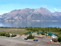
KLRS was established in 1961 by Walter Wood and the Arctic Institute of North America. Wood had been mapping, photographing, and collecting climate data in the area since 1935. The station has evolved from a few tents beside a military airstrip to a comfortable base camp providing support for several satellite field camps. Up to 30 researchers can use the facility at a time (from April to September).

General research and databases

KLRS has hosted a wide variety of disciplines over the last 50 years. The main projects have been related to geology, glaciology and geophysics in the ice-field region, high-altitude physiology on Mt. Logan, a massive collaborative project investigating interactions within the boreal forest over several decades, climate modelling, and remote sensing throughout the region. The KLRS Bibliography can be accessed via www.arctic.ucalgary.ca/research/kluane-lake-research-station. The Arctic Institute of North America also maintains a major data base called ASTIS and publishes the quarterly journal “Arctic”.

Link to data: https://dataportal.eu-interact.org/stations

Station Monitoring

Human dimension

The study area at Kluane is within the traditional territory of Champagn Aishihik (CAFN), Kluane (KFN), or White River First Nations (WRFN). KFN citizens were very instrumental in the early years of the research station. We now work together sharing information and developing programs that will interest young people in research.

Access

The Station can be accessed by the Alaska Highway via Whitehorse, a community of 25000, with an international airport receiving at least five flights from major Canadian cities each day. Vehicle rental is available in Whitehorse. The drive to the research station takes two hours on a paved highway.

Member of: