Address

CEN station at Whapmagoostui-Kuujjuarapik
Centre d'études nordiques (CEN)
P.O. Box 59
22020 rue Principale
Kuujjuarapik,Quebec, Canada
J0M 1G0

Station manager

Mickaél Lemay
E-mail: mickael.lemay@cen.ulaval.ca

Contact Station

Phone: +1 819 929-3319
E-mail: station@cen.ulaval.ca

www.cen.ulaval.ca/en/page.aspx?lien=stationkuujjuarapik

Station Features

Opening year: 1971 Status: Open
  • Type of station: Station
  • Operational period – year-round or Month A to Month B: Year-round
  • Name of station owner: CEN/Université Laval in collaboration with Cree First Nation
  • Type of owner: Government
  • Name of managing institution: CEN/Université Laval
  • Managing Institution Country: Canada
  • Station owner country: Canada
  • Partner institution: Yes
  • Partner institution name: Cree First Nation of Whapmagoostui
  • Station latitude: 55,27575556
  • Station longitude: -77,74748889
  • Country (station location): Canada
  • Altitude of station: 50 m a.s.l
  • Min. altitude within study area: 0 m a.s.l
  • Max. altitude within study area: 140 m a.s.l
  • Nearest town/settlement: Whapmagoostui/Kuujjuarapik
  • Distance to nearest town/settlement: 0 km
  • Number of residents in nearest town: 1400
  • Distance to nearest research station: 160 km
  • Maps available at station:
  • Climate zone: Sub-Arctic
  • Period of measurments for climate data below [year to year]: Since 1957
  • Mean annual temperature: -4 °C
  • Mean temperature in February: -22,4 °C
  • Mean temperature in July: 12,7 °C
  • Precipitation type: Snow, Rain, Hail
  • Sea ice break up: June
  • River ice break up: June
  • Mean annual wind speed: 4,7 m/s
  • Maximum wind speed (absolute): 26,9 m/s
  • Landscape features Lake, River, Delta/estuarie, Sea
  • Permafrost zone Discontinuous
  • Vegetation zone Tree line, Shrub tundra, Forest tundra, Peatlands, Wetlands, Peatlands/mires, Evergreen forest

Facilities

  • Area under roof: 5860 m²
  • Max. number of visitors at a time : 28
  • Showers: Yes
  • Laundry facilities: Yes
  • Power supply – period (from ‘hour’ to ‘hour’ or 24 hours): 24 hours
  • Power supply - plug type A, B
  • Power sources at station Other
  • Logistics area: 948 m²
  • Workshops Mechanical, Metal, Plexiglas, Wood
  • Means of transportation to/from station Boat, Other
  • Air transport landing facilities at station Airstrip, Helipad
  • Airstrip (Length × Width) : 1531 × 45 m (lake: yes)
  • Airstrip surface : Gravel/Sand
  • Transport on land - at station ATV, Snowmobile, Car, Other
  • Transport on water - at station Zodiac, Open boat/Dhinghy, Closed boat
  • Water landing facilities Pontoon/float bridge, Warf/pier
  • Number of staff peak season/summer: 3
  • Number of staff off season/winter: 1
  • Staff able to assist (workshops): Yes - if time allows
  • Recommended safety equipment Satellite phone, Weapon/rifle, Other
  • Laboratory area: 1260 m²
  • Field to station Mobile phone, VHF, Satellite phone
  • Station to outside world Mobile phone, Internet, Other
  • IT Infrastructure Wifi, Computers, Printer
  • Medical facilities: Yes
  • Medical capability Medium
  • Distance to hospital (estimated time – hours): 0

Science

  • Transnational Access: Yes
  • Remote Access: No
  • INTERACT Virtual Access: Yes
  • Permitting issues categories
    • Permits required for access to the station
    • Permits required for studies
  • Partner institutions (involved in the operation of the station)
    • Partner institution
  • Climate
    • Snow
    • Rain
    • Hail
  • Housing and accomodation
    • Showers
    • Laundry facilities
    • A
    • B
    • C
    • D
    • E
    • F
    • G
    • H
    • I
    • J
    • K
    • L
    • M
    • N
    • O
    • Municipal grid
    • Diesel/oil/gas
    • Wood
    • Solar
    • Wind
    • Water
    • Geothermal
    • Biofuel
    • Other
  • Logistics
    • Electrical and IT technologies
    • Mechanical
    • Metal
    • Wood
    • Plexiglas
    • Other
    • Walk
    • None
    • Tracked vehicle
    • Truck
    • SUV (4x4)
    • Car
    • ATV
    • Zodiac
    • Snowmobile
    • Open boat/Dhinghy
    • Closed boat
    • Bicycles
    • Amphibie vehicle
    • Ski
    • Other
    • Snow shoes
    • KickSledges
    • Other
    • Ski
    • Snowmobile
    • Boat
    • Car
    • Tracked vehicle
    • Truck
    • SUV (4x4)
    • Bus
    • Train
    • Airstrip
    • Scheduled flight
    • Helipad
    • Chartered plane/helicopter
    • Other
    • None
    • Harbour/port
    • Warf/pier
    • Pontoon/float bridge
    • Barges
    • Beach
  • Aircraft landing facilities
    • Helipad
  • Features in the facility area
    • Permanent snowpatches
    • Mountain
    • Valley
    • Lake
    • River
    • Shoreline
    • Tree line
    • Polar deserts/semi-deserts
    • Shrub tundra
    • Gramminoid tundra
    • Forest tundra
    • Peatlands
    • Wetlands
    • Palsa mires
    • Deciduous forest
    • Evergreen forest
    • Human settlements or resource use in the area
    • Arable land
    • Other
  • Main science disciplines
    • Astronomy
    • Atmospheric sciences
    • Cryology
    • Geology
    • Hydrology
    • Limnic biology
    • Marine biology
    • Terrestrial biology
    • Human biology
    • Anthropology
    • Archaeology
    • Sociology
    • Climate change
    • Environmental science (incl. pollution)
    • Oceanography
    • Agriculture
    • Animal husbandry
    • Fisheries
    • Forestry
    • Hunting
    • Tourism
  • Workshop facilities
    • Metal workshop
    • Wood workshop
    • Plexiglas workshop
    • Staff available to assist with constructions
  • Communication
    • Telephone
    • Satellite phone
    • VHF
    • E-mail
    • Internet
    • Computer
    • Printer
    • Scanner
    • Fax
  • Meteorology
    • Air temperature
    • Air humidity
    • Air pressure
    • Wind velocity
    • Wind direction
    • Precipitation
  • Sub-surface characteristics
    • Ground surface temperature
    • Soil temperature
    • Soil moisture
    • Ground water table
    • Soil water chemistry
    • Active layer depth
    • Permafrost distribution
    • Permafrost thickness
    • Permafrost temperature
  • Hydrology/Limnology
    • River water discharge/water level
    • Lake water level
    • Water balance
    • Water temperature
    • Lake ice cover (formation/breakup/thickness)
    • Suspended sediment discharge
    • Organic matter discharge
    • PAR (Photosyntetically Active Radiation)/secchi depth
    • Water chemistry
  • Greenhouse gas exchange
    • CO<sub>2</sub> exchange
    • CH<sub>4</sub> exchange
    • N<sub>2</sub>O exchange
  • Lake ecology
    • Phytoplankton (including chlorophyll)
    • Zooplankton
    • Vegetation
    • Fish
    • Invertebrates
    • Species list (community composition)
  • Vegetation
    • Flowering phenology
    • Amount of flowering
    • NDVI (plot/transect)
    • Landscape NDVI (from satellite images)
    • Vascular plant community composition
    • Bryophyte community composition
    • Lichen community composition
    • Fungi community composition
    • Berry production
    • Aerobiological monitoring (pollen, spores, etc.)
    • Species list (community composition)
  • Energy balance and radiation
    • Energy balance
    • Short wave incoming
    • Short wave outgoing
    • Long wave incoming
    • Long wave outgoing
    • Net radiation
    • UV-B
    • Multi-spectral
    • Cloud cover/hours of sunshine
  • Snow characteristics
    • Snow depth
    • Snow cover
    • Snow density
    • Snow temperature
  • Climate
    • Climate measurements
    • Energy balance
  • Landscape and environment
    • Mountains
    • Nunataks
    • Volcano/crater
    • Lava fields
    • Plateaus
    • Moraines
    • Valleys
    • Homothermic Springs
    • Lake
    • Thermokarst lake
    • River
    • Delta/estuarie
    • Fjord
    • Continuous
    • Sea
    • Discontinuous
    • Beach
    • Sporadic
    • Rocky shores
    • Pingos/ice lenses
    • Sea cliffs
    • Other (text)
    • Palsa mires
    • None
    • Ice Caps
    • Glaciers
    • Permanent snow patches
    • None
    • Tree line
    • Polar desert/Semi-desert
    • Gramminoid tundra
    • Shrub tundra
    • Forest tundra
    • Wetlands
    • Peatlands/mires
    • Salt marshes/lagoons
    • Heath
    • Grassland
    • Deciduous forest
    • Evergreen forest
    • Terrestrial carnivores
    • Alpine heath
    • Ungulates
    • Hares
    • Other (text)
    • Rodents
    • Bird colonies
    • Polar bear
    • Whales
    • Seals
    • Fish
    • Settlement
    • Fishing
    • Hunting
    • Forestry
    • Agriculture
    • Tourism
    • Animal husbandry
    • Leisure activities
  • Field equipment
    • PLB
    • VHF
    • HF
    • Satellite phone
    • Mobile phone
    • GPS
    • Weapon/rifle
    • Flare gun
    • Bearspray
    • PLB
    • First aid kit
    • Glacier rescue kit
    • VHF
    • Avalanche rescue kit
    • HF
    • Satellite phone
    • Overnight equipment
    • Other
    • Mobile phone
    • GPS
    • Weapon/rifle
    • Flare gun
    • Bearspray
    • PLB
    • First aid kit
    • Glacier rescue kit
    • VHF
    • Avalanche rescue kit
    • HF
    • Satellite phone
    • Overnight equipment
    • Other
    • Mobile phone
    • GPS
    • Weapon/rifle
    • Flare gun
    • Bearspray
    • Tent
    • First aid kit
    • Glacier rescue kit
    • Sleeping matress
    • Avalanche rescue kit
    • Sleeping bag
    • Cooking equipment and utensils
    • Overnight equipment
    • Other
    • Gas/alcohol for cooking
    • Field power supply available at station
  • Laboratory
    • Freezer < -80
    • Freezer -40 - -10
    • Fridge
    • Microscopes
    • Basic laboratory equipment
    • Advanced laboratory equipment
    • Basic chemical reagents
    • Analytical instrumentation
    • Other
    • Laboratory available in nearby town/settlement
  • Communication and IT
    • Mobile phone
    • VHF
    • Satellite phone
    • Other
    • Satellite phone
    • Mobile phone
    • Internet
    • Other
    • Wireless transfer of data from field site to station
    • Wifi
    • Computers
    • Printer
    • Data storage
    • Statistical tools
    • GIS tools
    • Other
  • Medical facilities
    • Medical facilities
    • Basic
    • Medium
    • Extensive
    • Dental
    • Surgery
    • Other
    • No
    • In peak season
    • When open

Station name and owner

The CEN Whapmagoostui-Kuujjuarapik Research Station is owned and run by the Centre d'études Nordiques (CEN: Centre for Northern Studies) with its secretariat based at the Université Laval, Québec, Canada. It is on Cree land and is run in collaboration with the Cree First Nation of Whapmagoostui.

Location

The CEN Whapmagoostui-Kuujjuarapik Research Station (55°16'N, 76°32'W) is located on the eastern shore of Hudson Bay at the maritime limit of James Bay, and in the adjacent villages of Whapmagoostui (Cree First Nation) and Kuujjuarapik (Inuit).

Climate data

Grey colours are WMO Climate Normals including maximum and minimum values. Blue colours are individual years.

Climate data for the stations where extracted via Copernicus Climate Data Store, from the global gridded reanalysis product: ERA5 monthly averaged data on single levels from 1940 to present. Description and source code: Roemer J.K. 2023. https://doi.org/10.5281/zenodo.10214922 Data Source: Hersbach et al. 2023. Copernicus Climate Change Service (C3S) Climate Data Store (CDS), https://doi.org/10.24381/cds.f17050d7

Biodiversity and natural environment

The climate at Whapmagoostui-Kuujjuarapik is strongly influenced by the proximity of Hudson Bay, and the recent pronounced loss of sea ice in this sector of northern Canada has been accompanied by large increases in air temperature. Discontinuous or scattered permafrost occurs throughout the region and is degrading rapidly. Whapmagoostui-Kuujjuarapik is located at the terrestrial boundary between taiga and tundra. South of the Great Whale River is the taiga zone (Boreal forest), while north of the river, the forest tundra zone progressively dominates the landscape. The vegetation type is coastal forest tundra, with some 400 recorded species. Parabolic dunes occur along the coast and are strongly influenced by plant cover. Paleoecological studies have documented the Holocene evolution of landscapes, including lakes, wetlands, and forests. The Manitounuk Islands, located just a little north along the coast, are part of the Hudsonian cuestas that are characterized by rocky beaches and vertiginous cliffs.

History and facilities

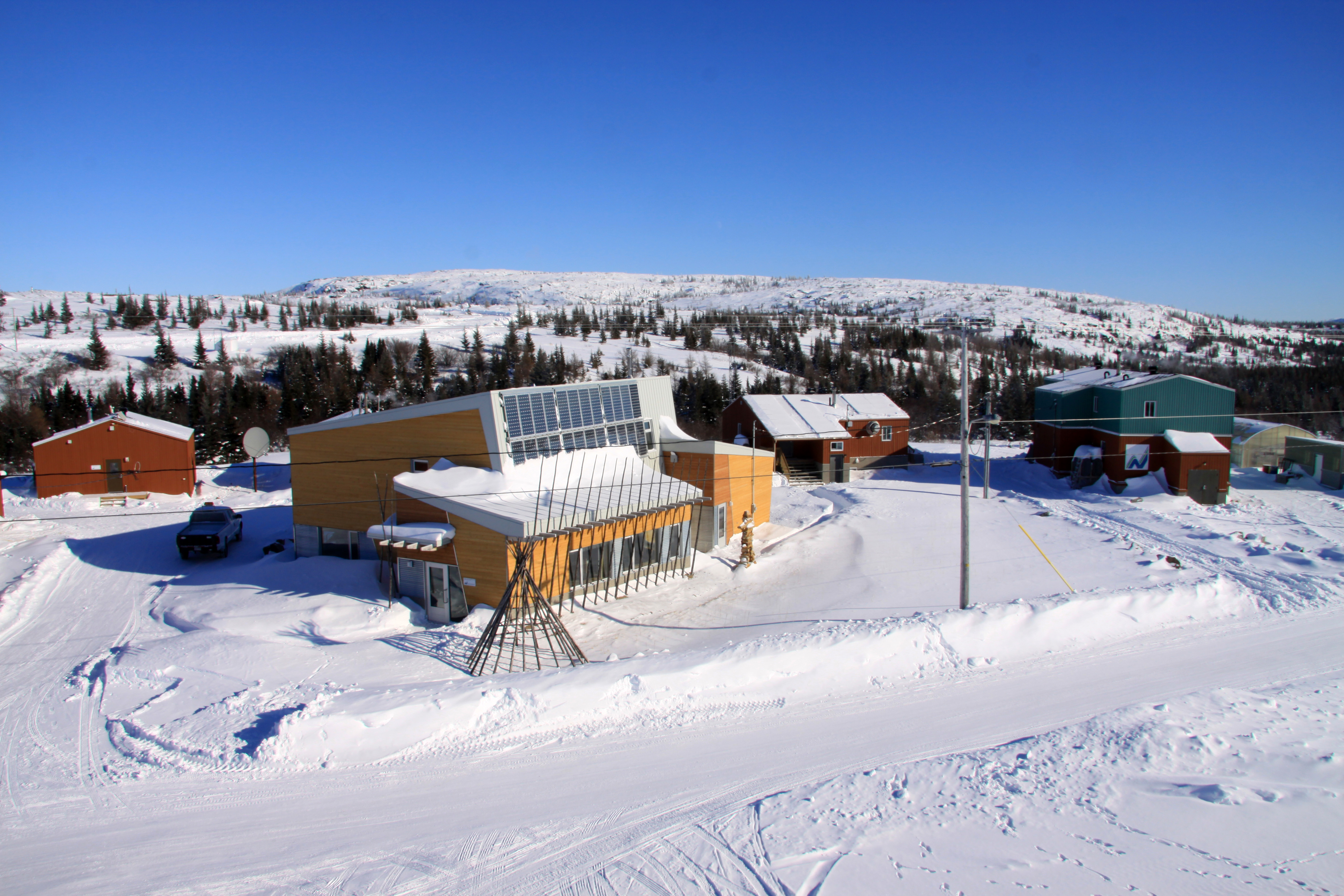
The first signs of human occupation in the Whapmagoostui-Kuujjuarapik region have been dated at 3800 BP. In the past, the English name Great Whale and the French name Poste-de-la-&shy;Baleine have been used to designate this community. The Hudson Bay Company (HBC) established the first fur trade post here in 1750 and marked the onset of continuous occupation. This station is the CEN&rsquo;s principal field station and has operated since the 1970s, with diverse research projects on past and present environments. In 2010, major upgrades to the station were undertaken, consisting of the construction of a state-of-art Community Science Centre to serve the needs of the circumpolar science community for research planning, information exchange, national research workshops, and coordination of field operations, and the local communities for information exchange, identification of northern research needs, science training of northerners, exchange of traditional knowledge, and outreach activities. The centre offers a conference room with a capacity for 50 participants, a permanent, interactive display on local natural history and on CEN research activities. In addition to this new building, the station also has wet and dry laboratories, a greenhouse, a dormitory, a cafeteria (with full-meal services during the summer season), vehicles for rent, wireless internet, rental of sampling and camping equipment, and an onsite station manager.

General research and databases

Current projects include work on biodiversity and dynamics of northern aquatic ecosystems; impacts of thawing permafrost in the context of global warming; wetland paleoecology; restoration of vegetation in degraded sites, and research on mercury dynamics (in relation to air, precipitation, snow). An overview of past studies in this region is given in: Bhiry, N., et al., 2011: Ecoscience 18: 182-203. CEN operates several climate stations in the area. In addition to the available scientific literature, CEN has extensive climate data recorded since 1957 which are available through Nordicana D: www.cen.ulaval.ca/nordicanad/.

Link to data: https://dataportal.eu-interact.org/stations

Station Monitoring

Human dimension

This bicultural community represents the ancestral limit of the Cree and Inuit territories. It is both the northernmost Cree community and the southernmost Inuit community in Quebec. Whapmagoostui-Kuujjuarapik has a population of about 1600 inhabitants. The spoken languages are Cree, Inuktitut, and English with some French. Rapid social, economic, and environmental change, initiated in the mid-20th century, continues to this day.

Access

Whapmagoostui-Kuujjuarapik is only accessible by commercial airlines. All research activities must be planned well in advance. Local guides and translators are available for hire. Access to the surrounding area by chartered flights, boat, and ATVs can be organized by the station manager.

Member of: