Greenland Institute of Natural Resources (GINR) with a field station in Kobbefjord (KB)
Address
PinngortitaleriffikGreenland Institute of Natural Resources
Kivioq 2
PO Box 570
3900 Nuuk
Greenland
Also, a research/field station in Kobbefjord.
Station manager
Katrine RaundrupStation Features
Opening year: 1995 Status: Open- Type of station: Station
- Operational period: Year-round (KB: May-September)
- Name of station owner: Greenland Institute of Natural Resources
- Type of owner: Government
- Name of managing institution: Greenland Institute of Natural Resources
- Managing Institution Country: Greenland
- Station owner country: Greenland
- Partner institution: No
- Station latitude: 64,19043889
- Station longitude: -51,69535000
- Country (station location): Greenland
- Altitude of station: 50 m a.s.l
- Min. altitude within study area: 0 m a.s.l
- Max. altitude within study area: 1600 m a.s.l
- Nearest town/settlement: Nuuk
- Distance to nearest town/settlement: 0 km
- Number of residents in nearest town: 19880
- Distance to nearest public transport facility (Airport, Ferry terminal, Train station, Bus station): 0 km
- Distance to nearest research station: 310 km
- Maps available at station: Map (1:75 000 ), aerial image, satellite image, Google Earth
- Type of surface facility is built on: Rock
- Climate zone: Low Arctic
- Period of measurements for climate data below: 1958- (KB: 2008-)
- Mean annual temperature: -0,4 °C
- Mean temperature in February: -9 °C
- Mean temperature in July: 10,6 °C
- Precipitation type: Snow, Rain
- Snow free period (month to month): May - October
- Lake ice break up: May, June
- Mean annual wind speed: 5,9 m/s
- Maximum wind speed (absolute): 36 m/s
- Landscape features Mountains, Valleys, Lake, River, Fjord, Sea
- Permafrost zone Sporadic
- Snow and ice on land Glaciers
- Vegetation zone Shrub tundra, Wetlands
- Wildlife Terrestrial carnivores, Ungulates, Hares, Whales, Seals, Fish
- Human use Settlement, Fishing, Hunting, Tourism, Leisure activities, Agriculture, Animal husbandry
Facilities
- Area under roof: 1850 m²
- Max. number of visitors at a time : 25
- Showers: Yes
- Laundry facilities: Yes
- Power supply - period: 24 Hours
- Power supply - plug type C, E, F, K
- Power sources at station Water
- Logistics area: 1500 m²
- Conference room capacity: 80
- Workshops Metal, Wood
- Means of transportation to/from station Car, Other
- Air transport landing facilities at station Airstrip, Helipad
- Airstrip (Length × Width) : 950 × 18 m (only in Nuuk: airport is regular operated by “Greenland Airports”)
- Airstrip surface : Tarmac/Concrete
- Transport on land - at station Snowmobile, Car
- Transport on water - at station Closed boat
- Water landing facilities None, Pontoon/float bridge, Harbour/port
- Number of staff peak season/summer: 70
- Number of staff off season/winter: 70
- Staff able to assist (fieldwork): Yes - if time allows
- Staff able to assist (workshops): Yes - if time allows
- Compulsory safety equipment VHF
- Recommended safety equipment Weapon/rifle, Other, Satellite phone, GPS, Flare gun, First aid kit
- Laboratory area: 250 m²
- Field to station Mobile phone, VHF, Satellite phone
- Station to outside world Mobile phone, Internet
- IT Infrastructure Wifi, Computers, Printer
- Medical facilities: Yes
- Medical capability Extensive
- Staff with medical training/doctor No
- Distance to hospital (estimated time – hours): 0
Science
- Arctic Council working groups
- AACA - Adaptation Actions for a Changing Arctic (Arctic), http://www.amap.no/adaptation-actions-for-a-changing-arctic-part-c
- AMAP - Arctic Monitoring and Assessment Programme (Arctic), http://www.amap.no/
- CAFF Circum Arctic Rangifer Monitoring and Assessment Network (Arctic), https://carma.caff.is/
- CAFF Seabird Group (Arctic), https://www.caff.is/seabirds-cbird
- Circumpolar Biodiversity Monitoring Programme (Arctic), https://www.caff.is/monitoring
- Scientific networks
- Herbivory network (Global), http://herbivory.biology.ualberta.ca/
- ICOS - Integrated Carbon Observation System (Global), https://www.icos-ri.eu/home
- ITEX - International Tundra Experiment (Global), http://ibis.geog.ubc.ca/itex/
- WMO - WHYCOS - World Hydrological Cycle Observing System (Global), http://www.whycos.org/whycos/
- WGMS - World Glacier Monitoring Service (Global), http://wgms.ch/
- Transnational Access: Yes
- Remote Access: Yes
- INTERACT Virtual Access: Yes
-
Permitting issues categories
- Permits required for access to the station
- Permits required for studies
-
Partner institutions (involved in the operation of the station)
- Partner institution
-
Climate
- Snow
- Rain
- Hail
-
Housing and accomodation
- Showers
- Laundry facilities
- A
- B
- C
- D
- E
- F
- G
- H
- I
- J
- K
- L
- M
- N
- O
- Municipal grid
- Diesel/oil/gas
- Wood
- Solar
- Wind
- Water
- Geothermal
- Biofuel
- Other
-
Logistics
- Electrical and IT technologies
- Mechanical
- Metal
- Wood
- Plexiglas
- Other
- Walk
- None
- Tracked vehicle
- Truck
- SUV (4x4)
- Car
- Zodiac
- ATV
- Snowmobile
- Open boat/Dhinghy
- Closed boat
- Bicycles
- Amphibie vehicle
- Ski
- Other
- Snow shoes
- KickSledges
- Other
- Ski
- Snowmobile
- Boat
- Car
- Tracked vehicle
- Truck
- SUV (4x4)
- Bus
- Train
- Airstrip
- Scheduled flight
- Helipad
- Chartered plane/helicopter
- Other
- None
- Harbour/port
- Warf/pier
- Pontoon/float bridge
- Barges
- Beach
-
Aircraft landing facilities
- Helipad
-
Features in the facility area
- Permanent snowpatches
- Mountain
- Valley
- Lake
- River
- Shoreline
- Tree line
- Polar deserts/semi-deserts
- Shrub tundra
- Gramminoid tundra
- Forest tundra
- Peatlands
- Wetlands
- Palsa mires
- Deciduous forest
- Evergreen forest
- Human settlements or resource use in the area
- Arable land
- Other
-
Main science disciplines
- Astronomy
- Atmospheric sciences
- Cryology
- Geology
- Hydrology
- Limnic biology
- Marine biology
- Terrestrial biology
- Human biology
- Anthropology
- Archaeology
- Sociology
- Climate change
- Environmental science (incl. pollution)
- Oceanography
- Agriculture
- Animal husbandry
- Fisheries
- Forestry
- Hunting
- Tourism
-
Workshop facilities
- Metal workshop
- Wood workshop
- Plexiglas workshop
- Staff available to assist with constructions
-
Communication
- Telephone
- Satellite phone
- VHF
- Internet
- Computer
- Printer
- Scanner
- Fax
-
Meteorology
- Air temperature
- Air humidity
- Air pressure
- Wind velocity
- Wind direction
- Precipitation
-
Energy balance and radiation
- Energy balance
- Short wave incoming
- Short wave outgoing
- Long wave incoming
- Long wave outgoing
- Net radiation
- UV-B
- Multi-spectral
- Cloud cover/hours of sunshine
-
Sub-surface characteristics
- Ground surface temperature
- Soil temperature
- Soil moisture
- Ground water table
- Soil water chemistry
- Active layer depth
- Permafrost distribution
- Permafrost thickness
- Permafrost temperature
-
Snow characteristics
- Snow depth
- Snow cover
- Snow density
- Snow temperature
-
Atmospheric composition
- CO<sub>2</sub> concentration
- CH<sub>4</sub> concentration
-
Greenhouse gas exchange
- CO<sub>2</sub> exchange
- CH<sub>4</sub> exchange
- N<sub>2</sub>O exchange
-
Energy budget
- Net radiation
- Sensible heat flux
- Latent heat flux
- Soil heat flux
-
Hydrology/Limnology
- River water discharge/water level
- Lake water level
- Water balance
- Water temperature
- Lake ice cover (formation/breakup/thickness)
- Suspended sediment discharge
- Organic matter discharge
- PAR (Photosyntetically Active Radiation)/secchi depth
- Water chemistry
-
Mass balace
- Mass balance
- Snow water equivalent
- Snowcover stratigraphy
- Equilibrium Line Altitude
- Duration of snow cover
- Calving flux
-
Climate
- Climate measurements
- Energy balance
-
Bio-geochemistry of snow, ice and water
- Biogeochemistry of snow, ice and water
-
Microbiology of snow, ice and water
- Microbiology of snow, ice and water
-
Vegetation
- Flowering phenology
- Amount of flowering
- NDVI (plot/transect)
- Landscape NDVI (from satellite images)
- Vascular plant community composition
- Bryophyte community composition
- Lichen community composition
- Fungi community composition
- Berry production
- Aerobiological monitoring (pollen, spores, etc.)
- Species list (community composition)
-
Arthropods
- Abundance
- Emergence phenology
- Insect herbivory
- Species list (community composition)
-
Birds
- Abundance
- Distribution
- Phenology
- Breeding birds
- Nest initiation phenology
- Nest predation rates
- Species list (community composition)
-
Lake ecology
- Phytoplankton (including chlorophyll)
- Zooplankton
- Vegetation
- Fish
- Invertebrates
- Species list (community composition)
-
Socio-ecological issues (disturbance)
- Number of visitors
- Surface activities (e.g. removal of vegetation, organisms, soil samples, ATV traffic, manipulations)
- Aircraft activities
- Emissions/discharge energy consumption, spill water, waste, garbage, atmospheric emissions, etc.)
-
Landscape and environment
- Mountains
- Nunataks
- Volcano/crater
- Lava fields
- Plateaus
- Moraines
- Valleys
- Homothermic Springs
- Lake
- Thermokarst lake
- River
- Delta/estuarie
- Fjord
- Sea
- Continuous
- Discontinuous
- Beach
- Sporadic
- Rocky shores
- Pingos/ice lenses
- Sea cliffs
- Other (text)
- Palsa mires
- Ice Caps
- None
- Glaciers
- Permanent snow patches
- None
- Tree line
- Polar desert/Semi-desert
- Gramminoid tundra
- Shrub tundra
- Forest tundra
- Wetlands
- Peatlands/mires
- Salt marshes/lagoons
- Heath
- Grassland
- Deciduous forest
- Terrestrial carnivores
- Evergreen forest
- Ungulates
- Alpine heath
- Hares
- Other (text)
- Rodents
- Bird colonies
- Polar bear
- Whales
- Seals
- Fish
- Settlement
- Fishing
- Hunting
- Forestry
- Agriculture
- Tourism
- Animal husbandry
- Leisure activities
-
Field equipment
- PLB
- VHF
- HF
- Satellite phone
- Mobile phone
- GPS
- Weapon/rifle
- Flare gun
- Bearspray
- PLB
- First aid kit
- Glacier rescue kit
- VHF
- Avalanche rescue kit
- HF
- Satellite phone
- Overnight equipment
- Other
- Mobile phone
- GPS
- Weapon/rifle
- Flare gun
- Bearspray
- First aid kit
- PLB
- Glacier rescue kit
- VHF
- Avalanche rescue kit
- HF
- Satellite phone
- Overnight equipment
- Other
- Mobile phone
- GPS
- Weapon/rifle
- Flare gun
- Bearspray
- Tent
- First aid kit
- Glacier rescue kit
- Sleeping matress
- Avalanche rescue kit
- Sleeping bag
- Cooking equipment and utensils
- Overnight equipment
- Other
- Gas/alcohol for cooking
- Field power supply available at station
-
Laboratory
- Freezer < -80
- Freezer -40 - -10
- Fridge
- Microscopes
- Basic laboratory equipment
- Advanced laboratory equipment
- Basic chemical reagents
- Analytical instrumentation
- Other
- Laboratory available in nearby town/settlement
-
Communication and IT
- Mobile phone
- VHF
- Satellite phone
- Other
- Satellite phone
- Mobile phone
- Internet
- Other
- Wireless transfer of data from field site to station
- Wifi
- Computers
- Printer
- Data storage
- Statistical tools
- GIS tools
- Other
-
Medical facilities
- Medical facilities
- Basic
- Medium
- Extensive
- Dental
- Surgery
- Other
- No
- In peak season
- When open
Station name and owner
Greenland Institute of Natural Resources (GINR) is owned by the Government of Greenland.
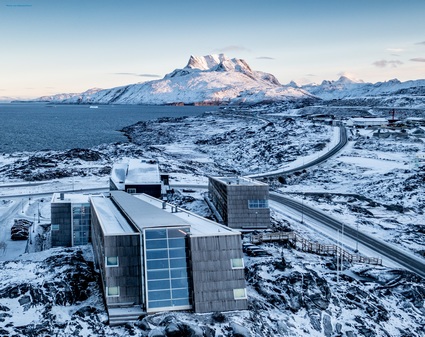
Location
The Greenland Institute of Natural Resources with its main buildings, laboratories, and living quarters is located in Nuuk, Greenland (64°11’ N, 51°41’ W). A research/field station is located in Kobbefjord (64°08’ N, 51°23’ W), c. 25 km southeast of Nuuk.
Climate data
Grey colours are WMO Climate Normals including maximum and minimum values. Blue colours are individual years.
Climate data for the stations where extracted via Copernicus Climate Data Store, from the global gridded reanalysis product:
ERA5 monthly averaged data on single levels from 1940 to present.
Description and source code: Roemer J.K. 2023. https://doi.org/10.5281/zenodo.10214922
Data Source: Hersbach et al. 2023. Copernicus Climate Change Service (C3S) Climate Data Store (CDS), https://doi.org/10.24381/cds.f17050d7
Biodiversity and natural environment
GINR and the Kobbefjord field station provide access to a low arctic ecosystem in West Greenland with different biotopes such as dwarf-shrub heaths, fens, grasslands, and lakes. Monitoring of a variety of parameters on vegetation, arthropods, mammals (both terrestrial and marine), birds, freshwater lakes, and the marine environment has been carried out at GINR for several years.
History and facilities
GINR was founded in 1995 (preceded by Greenland Fisheries Research; established in 1946), and the main building was inaugurated in 1998. The main building houses c. 3000 m2 of facilities necessary for the Institute’s activities, i.e. offices, laboratories, deep-freeze rooms, storage, conference room, and meeting rooms. Adjacent to the main building is an 850 m2 annex with a large multi-room used for meetings and seminars. Furthermore, the annex has five apartments and eight rooms for visiting researchers, as well as a garage/storage room. GINR has a third building near the city centre of Nuuk with furnished guest rooms for students and visiting scientists. In addition to the buildings in Nuuk, GINR owns two field stations, one in Kobbefjord, near Nuuk, and another in Niaqornat, in the Uummannaq area, Northwest Greenland. These field stations function as bases for small research teams and accommodates four people each. GINR owns two research vessels, Sanna and Tarajoq, which are used for scientific investigations in both sheltered and open waters. Also, the institute has several small boats and aluminium dinghies. For transport on land, GINR owns four cars and several snowmobiles.
General research and databases
Research and monitoring activities focus on living marine resources (fish, shellfish, marine mammals, and birds), land-based resources (land mammals and vegetation), as well as physical and chemical processes in the environment in relation to Climate Change and its impact on society. Population assessments and management advice are produced and reviewed in scientific committees under various international bodies where GINR is represented. GINR takes part in the monitoring programme Greenland Ecosystem Monitoring (www.g-e-m.dk). The objective is to provide long-term data series of the natural innate oscillations and plasticity of arctic ecosystems. This is accomplished through monitoring of selected biotic parameters and elements throughout the year on a long-term basis. Data from the monitoring is provided free of charge.
Link to data: https://dataportal.eu-interact.org/stations
Station Monitoring
-
Climate
- Meteorology
- Energy balance and radiation
-
Geo
- Sub-surface characteristics
- Snow characteristics
- Greenhouse gas exchange
- Energy budget
- Hydrology/Limnology
-
Glacier
- Mass balace
- Climate
- Microbiology of snow, ice and water
-
Bio
- Vegetation
- Arthropods
- Birds
- Lake ecology
- Socio-ecological issues (disturbance)
Human dimension
GINR is located in Nuuk, the capital of Greenland, with c. 19000 inhabitants. GINR actively communicates with users of the environment (fishermen, hunters, and recreational users) and with direct recipients of scientific advice (e.g. politicians). Users of the environment and their comprehensive knowledge of the natural environment are included during planning and implementation of the institute’s activities. Fishing and hunting is part of the traditional culture and is still practiced professionally and for recreational purposes.
Access
Nuuk can be reached by air directly from Copenhagen (www.airgreenland.com) or via Reykjavik, Iceland (www.icelandair.com). Transportation to the field station in Kobbefjord is by one of GINR’s own smaller boats carrying up to 10 people.