
Zackenberg Research Station
Address
Zackenberg SecretariatAarhus University,
Department of Ecoscience
Frederiksborgvej 399
DK-4000 Roskilde
Denmark
Station manager
Marcin Antoni Jackowicz-KorczynskiStation Features
Opening year: 1995 Status: Open- Type of station: Station
- Operational period: (March-April), May-October
- Name of station owner: Government of Greenland
- Type of owner: Government
- Name of managing institution: Department of Ecoscience, Aarhus University
- Managing Institution Country: Denmark
- Station owner country: Greenland
- Partner institution: No
- Station latitude: 74,46948050
- Station longitude: -20,57501264
- Country (station location): Greenland
- Altitude of station: 38 m a.s.l
- Min. altitude within study area: 0 m a.s.l
- Max. altitude within study area: 1492 m a.s.l
- Nearest town/settlement: Ittoqqortoormiit (503 inhabitants)
- Distance to nearest town/settlement: 450 km
- Number of residents in nearest town: 345
- Distance to nearest research station: 460 km
- Maps available at station: Map 1:250 000, aerial image, satellite image, Google Earth with low resolution
- Type of surface facility is built on: Soft substrate
- Climate zone: High Arctic
- Period of measurements for climate data below: –
- Mean annual temperature: -9,2 °C
- Mean temperature in February: -19,4 °C
- Mean temperature in July: 6,1 °C
- Precipitation type: Snow, Rain
- Sea ice break up: July
- Lake ice break up: May
- River ice break up: May
- Dominant wind direction: Northwest
- Mean annual wind speed: 2,8 m/s
- Maximum wind speed (absolute): 29,6 m/s
- Landscape features Mountains, Valleys, Lake, River, Sea
- Permafrost zone Continuous
- Snow and ice on land Ice Caps, Glaciers, Permanent snow patches
- Vegetation zone Shrub tundra, Gramminoid tundra, Peatlands, Wetlands
- Wildlife Terrestrial carnivores, Ungulates, Hares, Rodents, Polar bear, Fish
Facilities
- Area under roof: 650 m²
- Max. number of visitors at a time : 21
- Showers: Yes
- Laundry facilities: Yes
- Power supply - period: 24 Hours
- Power supply - plug type C, E, F, K
- Power sources at station Diesel/oil/gas, Other, Solar
- Logistics area: 150 m²
- Workshops Metal, Plexiglas, Wood
- Means of transportation to/from station Chartered plane/helicopter
- Air transport landing facilities at station Airstrip, Helipad
- Airstrip (Length × Width) : 380 × 20 m
- Airstrip surface : Gravel/Sand
- Transport on land - at station ATV, Snowmobile
- Transport on water - at station Open boat/Dhinghy
- Number of staff peak season/summer: 4
- Number of staff off season/winter: 1
- Staff able to assist (fieldwork): Yes - if time allows
- Staff able to assist (workshops): Yes - if time allows
- Compulsory safety equipment VHF, Weapon/rifle, Flare gun, First aid kit
- Recommended safety equipment PLB, Other, Satellite phone, GPS
- Safety equipment available at station VHF, GPS, Weapon/rifle, Flare gun, First aid kit
- Camping equipment available at station Sleeping matress, Sleeping bag
- Laboratory area: 40 m²
- Laboratory equipment Freezer -40 - -10, Fridge, Microscopes, Basic laboratory equipment
- Medical facilities: Yes
- Medical capability Basic
- Staff with medical training/doctor When open
- Distance to hospital (estimated time – hours): 10
- Field to station VHF, Satellite phone
- Station to outside world Internet, Satellite phone
- Wireless transfer of data from field site to station: Yes
- IT Infrastructure Wifi
Science
- Arctic Council working groups
- AACA - Adaptation Actions for a Changing Arctic (Arctic), http://www.amap.no/adaptation-actions-for-a-changing-arctic-part-c
- AMAP - Arctic Monitoring and Assessment Programme (Arctic), http://www.amap.no/
- CAFF Circumpolar Flora Group (Arctic), https://www.caff.is/flora-cfg
- CAFF Seabird Group (Arctic), https://www.caff.is/seabirds-cbird
- Circumpolar Biodiversity Monitoring Programme (Arctic), https://www.caff.is/monitoring
- Scientific networks
- Arctic Birds Breeding Condition Survey (Arctic), http://www.arcticbirds.net/
- ACD - Arctic Coastal Dynamics (Arctic), https://arcticcoast.info/
- GTN-G - Global Terrestrial Network - Glaciers (Global), http://www.gtn-g.ch/
- GTN-P - Global Terrestrial Network - Permafrost (Global), http://gtnp.arcticportal.org/
- Herbivory network (Global), http://herbivory.biology.ualberta.ca/
- ICOS - Integrated Carbon Observation System (Global), https://www.icos-ri.eu/home
- ITEX - International Tundra Experiment (Global), http://ibis.geog.ubc.ca/itex/
- IPA - CALM - Circumarctic Active Layer Monitoring (Arctic), https://www2.gwu.edu/~calm/
- NeAT - Network for Arthropods of the Tundra (Global), https://tundraarthropods.wordpress.com/
- PCN - Permafrost Carbon Network (Global), http://www.permafrostcarbon.org/
- FLUXNET - Terrestrial Carbon Flux Network (Global), http://fluxnet.fluxdata.org/about/
- WMO - GCW - Global Cryosphere Watch (Global), http://globalcryospherewatch.org/cryonet/
- WMO - GRDC - Global Runoff Data Centre (Global), http://www.bafg.de/GRDC/EN/Home/homepage_node.html
- WMO - WHYCOS - World Hydrological Cycle Observing System (Global), http://www.whycos.org/whycos/
- Transnational Access: Yes
- Remote Access: Yes
- INTERACT Virtual Access: Yes
-
Permitting issues categories
- Permits required for access to the station
- Permits required for studies
-
Partner institutions (involved in the operation of the station)
- Partner institution
-
Climate
- Snow
- Rain
- Hail
-
Housing and accomodation
- Showers
- Laundry facilities
- A
- B
- C
- D
- E
- F
- G
- H
- I
- J
- K
- L
- M
- N
- O
- Municipal grid
- Diesel/oil/gas
- Wood
- Solar
- Wind
- Water
- Geothermal
- Biofuel
- Other
-
Logistics
- Electrical and IT technologies
- Mechanical
- Metal
- Wood
- Plexiglas
- Other
- Walk
- None
- Tracked vehicle
- Truck
- SUV (4x4)
- Car
- ATV
- Zodiac
- Snowmobile
- Open boat/Dhinghy
- Closed boat
- Bicycles
- Amphibie vehicle
- Ski
- Other
- Snow shoes
- KickSledges
- Other
- Ski
- Snowmobile
- Boat
- Car
- Tracked vehicle
- Truck
- SUV (4x4)
- Bus
- Train
- Airstrip
- Scheduled flight
- Helipad
- Chartered plane/helicopter
- Other
- None
- Harbour/port
- Warf/pier
- Pontoon/float bridge
- Barges
- Beach
-
Aircraft landing facilities
- Helipad
-
Features in the facility area
- Permanent snowpatches
- Mountain
- Valley
- Lake
- River
- Shoreline
- Tree line
- Polar deserts/semi-deserts
- Shrub tundra
- Gramminoid tundra
- Forest tundra
- Peatlands
- Wetlands
- Palsa mires
- Deciduous forest
- Evergreen forest
- Human settlements or resource use in the area
- Arable land
- Other
-
Main science disciplines
- Astronomy
- Atmospheric sciences
- Cryology
- Geology
- Hydrology
- Limnic biology
- Marine biology
- Terrestrial biology
- Human biology
- Anthropology
- Archaeology
- Sociology
- Climate change
- Environmental science (incl. pollution)
- Oceanography
- Agriculture
- Animal husbandry
- Fisheries
- Forestry
- Hunting
- Tourism
-
Workshop facilities
- Metal workshop
- Wood workshop
- Plexiglas workshop
- Staff available to assist with constructions
-
Communication
- Telephone
- Satellite phone
- VHF
- Internet
- Computer
- Printer
- Scanner
- Fax
-
Meteorology
- Air temperature
- Air humidity
- Air pressure
- Wind velocity
- Wind direction
- Precipitation
-
Energy balance and radiation
- Energy balance
- Short wave incoming
- Short wave outgoing
- Long wave incoming
- Long wave outgoing
- Net radiation
- UV-B
- Multi-spectral
- Cloud cover/hours of sunshine
-
Geology/Geomorphology
- Quaternary geology
- Sedimentology
- Bedrock geology
- Erosion
-
Sub-surface characteristics
- Ground surface temperature
- Soil temperature
- Soil moisture
- Ground water table
- Soil water chemistry
- Active layer depth
- Permafrost distribution
- Permafrost thickness
- Permafrost temperature
-
Snow characteristics
- Snow depth
- Snow cover
- Snow density
- Snow temperature
-
Atmospheric composition
- CO<sub>2</sub> concentration
- CH<sub>4</sub> concentration
-
Greenhouse gas exchange
- CO<sub>2</sub> exchange
- CH<sub>4</sub> exchange
- N<sub>2</sub>O exchange
-
Energy budget
- Net radiation
- Sensible heat flux
- Latent heat flux
- Soil heat flux
-
Hydrology/Limnology
- River water discharge/water level
- Lake water level
- Water balance
- Water temperature
- Lake ice cover (formation/breakup/thickness)
- Suspended sediment discharge
- Organic matter discharge
- PAR (Photosyntetically Active Radiation)/secchi depth
- Water chemistry
-
Pollution
- In air
- In water
- In soil
- In snow/ice
- Contaminants in species
-
Glacier characteristics
- Glacier area
- Topography
- Elevation change
- Terminus position
- Ice velocity
- Ice thickness
- Debris cover
- Surface albedo/reflexion coefficient
-
Mass balace
- Mass balance
- Snow water equivalent
- Snowcover stratigraphy
- Equilibrium Line Altitude
- Duration of snow cover
- Calving flux
-
Climate
- Climate measurements
- Energy balance
-
Glacier hydrology
- Run-off
- Supra-, en- and subglacial drainage system
- Meltwater retention
- Glacial lake outburst floods
-
Vegetation
- Flowering phenology
- Amount of flowering
- NDVI (plot/transect)
- Landscape NDVI (from satellite images)
- Vascular plant community composition
- Bryophyte community composition
- Lichen community composition
- Fungi community composition
- Berry production
- Aerobiological monitoring (pollen, spores, etc.)
- Species list (community composition)
-
Birds
- Abundance
- Distribution
- Phenology
- Breeding birds
- Nest initiation phenology
- Nest predation rates
- Species list (community composition)
-
Mammals
- Mammal abundance
- Mammal distribution
- Mammal reproduction
- Mortality
- Predation
- Physiology
- Species list (community composition)
-
Lake ecology
- Phytoplankton (including chlorophyll)
- Zooplankton
- Vegetation
- Fish
- Invertebrates
- Species list (community composition)
-
Genetics
- Collection of genetic material
-
Pollution
- Pollution measurements in vegetation
- Pollution measurements in water
- Pollution measurements in mammals (body burdens, biomarkers)
- Pollution measurements in birds (body burdens, biomarkers on both adults and offspring e.g. egg shell thinning, macro plastic in nests/in body)
-
Diseases
- Mammals
- Birds
- Fish
- Vegetation
- Other
-
Socio-ecological issues (disturbance)
- Number of visitors
- Surface activities (e.g. removal of vegetation, organisms, soil samples, ATV traffic, manipulations)
- Aircraft activities
- Emissions/discharge energy consumption, spill water, waste, garbage, atmospheric emissions, etc.)
-
Arthropods
- Abundance
- Emergence phenology
- Insect herbivory
- Species list (community composition)
-
Landscape and environment
- Mountains
- Nunataks
- Volcano/crater
- Lava fields
- Plateaus
- Moraines
- Valleys
- Homothermic Springs
- Lake
- Thermokarst lake
- River
- Delta/estuarie
- Fjord
- Continuous
- Sea
- Discontinuous
- Beach
- Sporadic
- Rocky shores
- Pingos/ice lenses
- Sea cliffs
- Other (text)
- Palsa mires
- Ice Caps
- None
- Glaciers
- Permanent snow patches
- None
- Tree line
- Polar desert/Semi-desert
- Gramminoid tundra
- Shrub tundra
- Forest tundra
- Wetlands
- Peatlands/mires
- Salt marshes/lagoons
- Heath
- Grassland
- Deciduous forest
- Terrestrial carnivores
- Evergreen forest
- Ungulates
- Alpine heath
- Hares
- Other (text)
- Rodents
- Bird colonies
- Polar bear
- Whales
- Seals
- Fish
- Settlement
- Fishing
- Hunting
- Forestry
- Agriculture
- Tourism
- Animal husbandry
- Leisure activities
-
Field equipment
- PLB
- VHF
- HF
- Satellite phone
- Mobile phone
- GPS
- Weapon/rifle
- Flare gun
- Bearspray
- PLB
- First aid kit
- Glacier rescue kit
- VHF
- Avalanche rescue kit
- HF
- Satellite phone
- Overnight equipment
- Other
- Mobile phone
- GPS
- Weapon/rifle
- Flare gun
- Bearspray
- PLB
- First aid kit
- VHF
- Glacier rescue kit
- Avalanche rescue kit
- HF
- Satellite phone
- Overnight equipment
- Other
- Mobile phone
- GPS
- Weapon/rifle
- Flare gun
- Bearspray
- Tent
- First aid kit
- Sleeping matress
- Glacier rescue kit
- Sleeping bag
- Avalanche rescue kit
- Cooking equipment and utensils
- Overnight equipment
- Other
- Gas/alcohol for cooking
- Field power supply available at station
-
Laboratory
- Freezer < -80
- Freezer -40 - -10
- Fridge
- Microscopes
- Basic laboratory equipment
- Advanced laboratory equipment
- Basic chemical reagents
- Analytical instrumentation
- Other
- Laboratory available in nearby town/settlement
-
Medical facilities
- Medical facilities
- Basic
- Medium
- Extensive
- Dental
- Surgery
- Other
- No
- In peak season
- When open
-
Communication and IT
- Mobile phone
- VHF
- Satellite phone
- Satellite phone
- Other
- Mobile phone
- Internet
- Other
- Wireless transfer of data from field site to station
- Wifi
- Computers
- Printer
- Data storage
- Statistical tools
- GIS tools
- Other
Station name and owner
Zackenberg Research Station is owned by the Government of Greenland. Aarhus University (Denmark) is responsible for running the station.
Location
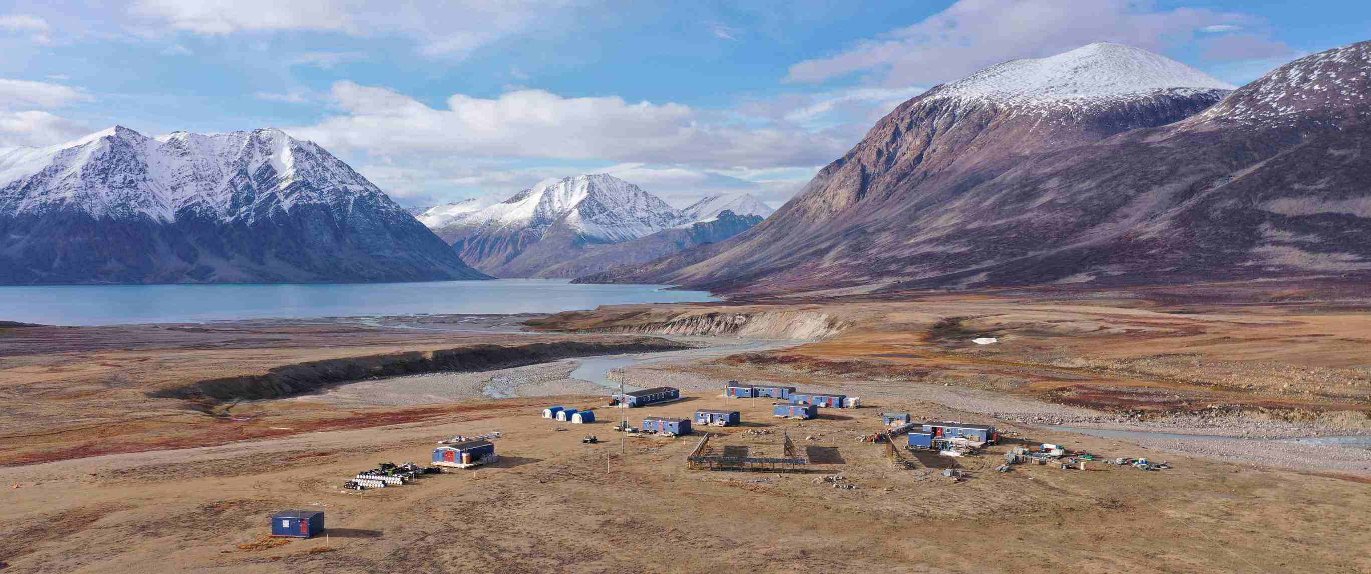
Zackenberg Research Station is located in Young Sund – Tyrolerfjord complex in Northeast Greenland. The station is situated in the southern part of the National Park of North and East Greenland, the largest national park in the world (approximately 1 million km2). The nearest settlement is the military outpost Daneborg (with a marine research facility) 25 km southeast of the station. The nearest town is Ittoqqortoormiit, 450 km south of the station.
Climate data
Grey colours are WMO Climate Normals including maximum and minimum values. Blue colours are individual years.
Climate data for the stations where extracted via Copernicus Climate Data Store, from the global gridded reanalysis product:
ERA5 monthly averaged data on single levels from 1940 to present.
Description and source code: Roemer J.K. 2023. https://doi.org/10.5281/zenodo.10214922
Data Source: Hersbach et al. 2023. Copernicus Climate Change Service (C3S) Climate Data Store (CDS), https://doi.org/10.24381/cds.f17050d7
Biodiversity and natural environment
Zackenberg Research Station is situated in the High Arctic in an area with continuous permafrost. The study area comprises the drainage basin of the river Zackenbergelven, with a total size of c. 500 km2. A great variety of biotopes like ponds, fens, heaths, fell field plateaus and grasslands occur within the core study area. Muskoxen, lemming, Arctic fox, and Arctic hare are among the common mammals in the area, while polar bear and Arctic wolf are occasional visitors.
History and facilities
In 1974, a national park was established in Northeast Greenland, which became a UNESCO Man and Biosphere Reserve in 1977. In 1991, the first expedition under the research programme Zackenberg Ecological Research Operations was made to Zackenberg. In 1995, a temporary field station was established, and in 1997 Zackenberg Research Station was officially opened. Each year, the station is manned from 1 May to 31 October. In the remaining part of the year, the station is only in use if needed. The station has 25 beds, two laboratories, a workshop, a mess with cook, and satellite-based telephone, fax, and email service. An accommodation and laboratory facility is located next to the military outpost Daneborg. This facility accommodates 10 scientists.
General research and databases
Zackenberg Research Station provides facilities for specific but comprehensive research projects and for an extensive long-term research/ monitoring programme. The Greenland Ecosystem Monitoring programme (GEM) runs five sub-programmes in Zackenberg: ClimateBasis (monitoring the climate), GeoBasis (monitoring the carbon balance of the ecosystem, other feedbacks to Climate Change, and physical landscape processes), BioBasis (monitoring the living nature), MarineBasis (monitoring physical and biological processes in the marine ecosystem), and GlacioBasis (monitoring the mass balance of local glaciers). At the station, there are approximately 25 ongoing projects per year, of which about two third focus on Climate Change feedbacks. Results from the research and monitoring at Zackenberg are reported in the GEM Annual Reports published by Aarhus University. PDF-versions of the annual reports are available at www.zackenberg.dk. The data from Zackenberg monitoring is available for direct access at https://data.g-e-m.dk/. This homepage also holds the manuals for the different monitoring sub-programmes. All data from Zackenberg are provided free-of-charge to any scientist interested in making use of the data for scientific purposes. Existing databases also include a bibliography of publications arising from research at the station since it opened in 1995, and a GIS of the study area with access through the internet.
Link to data: https://data.g-e-m.dk/
Station Monitoring
-
Climate
- Meteorology
- Energy balance and radiation
-
Geo
- Geology/Geomorphology
- Sub-surface characteristics
- Snow characteristics
- Atmospheric composition
- Greenhouse gas exchange
- Energy budget
- Hydrology/Limnology
- Pollution
-
Glacier
- Glacier characteristics
- Mass balace
- Climate
- Glacier hydrology
-
Bio
- Vegetation
- Arthropods
- Birds
- Mammals
- Lake ecology
- Genetics
- Socio-ecological issues (disturbance)
Human dimension
The nearest town is Ittoqqortoormiit, located approximately 450 km to the south, with a population of around 450 people. Zackenberg Research Station collaborates with other field stations in Greenland, including Arctic Station, Sermilik Station, and the Greenland Institute of Natural Resources. Asiaq also plays an active role in the work conducted at Zackenberg.
Access
Transport to and from Zackenberg Research Station is handled by the Zackenberg Secretariat at Aarhus University as a package solution from any airport serviced by Icelandair. Travels are based on a combination of commercial flights (to Akureyri on Iceland) and chartered flights (from Akureyri to Zackenberg). It is mandatory to submit an application to the Zackenberg Secretariat prior to the visit of the station. The application will be reviewed by a scientific committee and afterwards the secretariat will take care of all practicalities in relation to logistics.