Address

-      Villum Research Station secretariat
Department of Environmental Science
Aarhus University
Fredericksborgvej 399
DK-4000 Roskilde
Denmark

Station manager

Henrik Skov
E-mail: HSK@envs.au.dk

Contact Station

E-mail: NBH@envs.au.dk

https://villumresearchstation.dk/

Station Features

Opening year: 1990 Status: Open
  • Type of station: Station
  • Operational period – year-round or Month A to Month B: Year-round
  • Name of station owner: Government of Greenland
  • Type of owner: Government
  • Name of managing institution: Aarhus University
  • Managing Institution Country: Denmark
  • Station owner country: Greenland
  • Partner institution: No
  • Station latitude: 81,60146111
  • Station longitude: -16,66203056
  • Country (station location): Greenland
  • Altitude of station: 30 m a.s.l
  • Min. altitude within study area: 0 m a.s.l
  • Max. altitude within study area: 100 m a.s.l
  • Nearest town/settlement: Longyearbyen
  • Distance to nearest town/settlement: 722 km
  • Number of residents in nearest town: 2400
  • Distance to nearest research station: 608 km
  • Maps available at station: 1:1000, geological map, aerial images, sallite image, Google Earth
  • Climate zone: High Arctic
  • Period of measurments for climate data below [year to year]: 1990-2002 and since 2006
  • Mean annual temperature: -16,9 °C
  • Mean temperature in February: -30,9 °C
  • Mean temperature in July: 3,4 °C
  • Precipitation type: Snow
  • Sea ice break up: July, August
  • Dominant wind direction: South
  • Mean annual wind speed: 4 m/s
  • Maximum wind speed (absolute): 40 m/s
  • Landscape features Lake, River, Sea
  • Permafrost zone Continuous
  • Snow and ice on land Glaciers
  • Vegetation zone Polar desert/Semi-desert, Shrub tundra, Wetlands

Facilities

  • Area under roof: 600 m²
  • Max. number of visitors at a time : 24
  • Showers: Yes
  • Laundry facilities: Yes
  • Power supply – period (from ‘hour’ to ‘hour’ or 24 hours): 24 Hours
  • Power supply - plug type C, E, F, K
  • Power sources at station Diesel/oil/gas, Other
  • Logistics area: 400 m²
  • Workshops Metal, Wood
  • Air transport landing facilities at station Airstrip
  • Airstrip (Length × Width) : Landing airstrip
  • Airstrip surface : Gravel/Sand
  • Number of staff peak season/summer: 2
  • Number of staff off season/winter: 1
  • Compulsory safety equipment VHF
  • Recommended safety equipment Other
  • Laboratory area: 220 m²
  • Field to station VHF, Satellite phone
  • Station to outside world Internet, Other
  • IT Infrastructure Computers, Printer, Other
  • Medical facilities: Yes
  • Medical capability Extensive
  • Staff with medical training/doctor When open
  • Distance to hospital (estimated time – hours): 720

Science

  • Transnational Access: Yes
  • Remote Access: Yes
  • INTERACT Virtual Access: No
  • Permitting issues categories
    • Permits required for access to the station
    • Permits required for studies
  • Partner institutions (involved in the operation of the station)
    • Partner institution
  • Climate
    • Snow
    • Rain
    • Hail
  • Housing and accomodation
    • Showers
    • Laundry facilities
    • A
    • B
    • C
    • D
    • E
    • F
    • G
    • H
    • I
    • J
    • K
    • L
    • M
    • N
    • O
    • Municipal grid
    • Diesel/oil/gas
    • Wood
    • Solar
    • Wind
    • Water
    • Geothermal
    • Biofuel
    • Other
  • Logistics
    • Electrical and IT technologies
    • Mechanical
    • Metal
    • Wood
    • Plexiglas
    • Other
    • Walk
    • None
    • Tracked vehicle
    • Truck
    • SUV (4x4)
    • Car
    • ATV
    • Zodiac
    • Snowmobile
    • Open boat/Dhinghy
    • Closed boat
    • Bicycles
    • Amphibie vehicle
    • Ski
    • Other
    • Snow shoes
    • KickSledges
    • Other
    • Ski
    • Snowmobile
    • Boat
    • Car
    • Tracked vehicle
    • Truck
    • SUV (4x4)
    • Bus
    • Train
    • Airstrip
    • Scheduled flight
    • Chartered plane/helicopter
    • Helipad
    • Other
    • None
    • Harbour/port
    • Warf/pier
    • Pontoon/float bridge
    • Barges
    • Beach
  • Aircraft landing facilities
    • Helipad
  • Features in the facility area
    • Permanent snowpatches
    • Mountain
    • Valley
    • Lake
    • River
    • Shoreline
    • Tree line
    • Polar deserts/semi-deserts
    • Shrub tundra
    • Gramminoid tundra
    • Forest tundra
    • Peatlands
    • Wetlands
    • Palsa mires
    • Deciduous forest
    • Evergreen forest
    • Human settlements or resource use in the area
    • Arable land
    • Other
  • Main science disciplines
    • Astronomy
    • Atmospheric sciences
    • Cryology
    • Geology
    • Hydrology
    • Limnic biology
    • Marine biology
    • Terrestrial biology
    • Human biology
    • Anthropology
    • Archaeology
    • Sociology
    • Climate change
    • Environmental science (incl. pollution)
    • Oceanography
    • Agriculture
    • Animal husbandry
    • Fisheries
    • Forestry
    • Hunting
    • Tourism
  • Workshop facilities
    • Metal workshop
    • Wood workshop
    • Plexiglas workshop
    • Staff available to assist with constructions
  • Communication
    • Telephone
    • Satellite phone
    • VHF
    • E-mail
    • Internet
    • Computer
    • Printer
    • Scanner
    • Fax
  • Meteorology
    • Air temperature
    • Air humidity
    • Air pressure
    • Wind velocity
    • Wind direction
    • Precipitation
  • Energy balance and radiation
    • Energy balance
    • Short wave incoming
    • Short wave outgoing
    • Long wave incoming
    • Long wave outgoing
    • Net radiation
    • UV-B
    • Multi-spectral
    • Cloud cover/hours of sunshine
  • Sub-surface characteristics
    • Ground surface temperature
    • Soil temperature
    • Soil moisture
    • Ground water table
    • Soil water chemistry
    • Active layer depth
    • Permafrost distribution
    • Permafrost thickness
    • Permafrost temperature
  • Snow characteristics
    • Snow depth
    • Snow cover
    • Snow density
    • Snow temperature
  • Atmospheric composition
    • CO<sub>2</sub> concentration
    • CH<sub>4</sub> concentration
  • Hydrology/Limnology
    • River water discharge/water level
    • Lake water level
    • Water balance
    • Water temperature
    • Lake ice cover (formation/breakup/thickness)
    • Suspended sediment discharge
    • Organic matter discharge
    • PAR (Photosyntetically Active Radiation)/secchi depth
    • Water chemistry
  • Pollution
    • In air
    • In water
    • In soil
    • In snow/ice
    • Contaminants in species
  • Glacier characteristics
    • Glacier area
    • Topography
    • Elevation change
    • Terminus position
    • Ice velocity
    • Ice thickness
    • Debris cover
    • Surface albedo/reflexion coefficient
  • Greenhouse gas exchange
    • CO<sub>2</sub> exchange
    • CH<sub>4</sub> exchange
    • N<sub>2</sub>O exchange
  • Particles and aerosols
    • Particles and aerosols
  • Landscape and environment
    • Mountains
    • Nunataks
    • Volcano/crater
    • Lava fields
    • Plateaus
    • Moraines
    • Valleys
    • Homothermic Springs
    • Lake
    • Thermokarst lake
    • River
    • Delta/estuarie
    • Fjord
    • Sea
    • Continuous
    • Discontinuous
    • Beach
    • Sporadic
    • Rocky shores
    • Pingos/ice lenses
    • Sea cliffs
    • Other (text)
    • Palsa mires
    • Ice Caps
    • None
    • Glaciers
    • Permanent snow patches
    • None
    • Tree line
    • Polar desert/Semi-desert
    • Gramminoid tundra
    • Shrub tundra
    • Forest tundra
    • Wetlands
    • Peatlands/mires
    • Salt marshes/lagoons
    • Heath
    • Grassland
    • Deciduous forest
    • Evergreen forest
    • Terrestrial carnivores
    • Alpine heath
    • Ungulates
    • Hares
    • Other (text)
    • Rodents
    • Bird colonies
    • Polar bear
    • Whales
    • Seals
    • Fish
    • Settlement
    • Fishing
    • Hunting
    • Forestry
    • Agriculture
    • Tourism
    • Animal husbandry
    • Leisure activities
  • Field equipment
    • PLB
    • VHF
    • HF
    • Satellite phone
    • Mobile phone
    • GPS
    • Weapon/rifle
    • Flare gun
    • Bearspray
    • PLB
    • First aid kit
    • Glacier rescue kit
    • VHF
    • Avalanche rescue kit
    • HF
    • Satellite phone
    • Overnight equipment
    • Other
    • Mobile phone
    • GPS
    • Weapon/rifle
    • Flare gun
    • Bearspray
    • PLB
    • First aid kit
    • Glacier rescue kit
    • VHF
    • Avalanche rescue kit
    • HF
    • Satellite phone
    • Overnight equipment
    • Other
    • Mobile phone
    • GPS
    • Weapon/rifle
    • Flare gun
    • Bearspray
    • Tent
    • First aid kit
    • Glacier rescue kit
    • Sleeping matress
    • Avalanche rescue kit
    • Sleeping bag
    • Cooking equipment and utensils
    • Overnight equipment
    • Other
    • Gas/alcohol for cooking
    • Field power supply available at station
  • Laboratory
    • Freezer < -80
    • Freezer -40 - -10
    • Fridge
    • Microscopes
    • Basic laboratory equipment
    • Advanced laboratory equipment
    • Basic chemical reagents
    • Analytical instrumentation
    • Other
    • Laboratory available in nearby town/settlement
  • Communication and IT
    • Mobile phone
    • VHF
    • Satellite phone
    • Other
    • Satellite phone
    • Mobile phone
    • Internet
    • Other
    • Wireless transfer of data from field site to station
    • Wifi
    • Computers
    • Printer
    • Data storage
    • Statistical tools
    • GIS tools
    • Other
  • Medical facilities
    • Medical facilities
    • Basic
    • Medium
    • Extensive
    • Dental
    • Surgery
    • Other
    • No
    • In peak season
    • When open

Station name and owner

Villum Research Station (VRS) is owned by the Government of Greenland and operated by Aarhus University, Denmark.

Location

VRS is located on Princess Ingeborgs Peninsula (c. 20 ×15 km2 lowland plain) at the military facility, Station Nord, in North Greenland (81°36’ N, 16°39 W). The station is situated within the National Park of North and Northeast Greenland, the largest national park in the World. The military station has an average elevation of 30 m a.s.l. with a gentle slope to the coast. A 2 km gravel/ice runway, which is kept open year round, is the only gateway to Station Nord. The station acts as a gateway to the northern part of the National Park of North and Northeast Greenland.

Climate data

Grey colours are WMO Climate Normals including maximum and minimum values. Blue colours are individual years.

Climate data for the stations where extracted via Copernicus Climate Data Store, from the global gridded reanalysis product: ERA5 monthly averaged data on single levels from 1940 to present. Description and source code: Roemer J.K. 2023. https://doi.org/10.5281/zenodo.10214922 Data Source: Hersbach et al. 2023. Copernicus Climate Change Service (C3S) Climate Data Store (CDS), https://doi.org/10.24381/cds.f17050d7

Biodiversity and natural environment

The station is situated in the High Arctic, and the surroundings are mainly Polar Desert. The area has continuous permafrost, and a continuous snow cover characterise the area for almost ten month per year. The mean annual temperature is c. -17 °C and the mean annual precipitation is c. 190 mm. Mean monthly temperature is -31 °C during the coldest month (February) and 3 °C during the warmest month (July). The Princess Ingeborgs Peninsula plain consists of Quaternary raised marine silt, beach shingle, and glacial deposits. The Quaternary deposits are underlain by rocks of Permian age. Station Nord is situated very close to the Polar Sea, and the sea-ice conditions in the area are generally severe with heavy sea-ice throughout the year. Consequently, ships cannot service Station Nord. Provide access to another Greenland with unique arctic ecosystems including species like ivory ant geese, whales, and muskox.

History and facilities

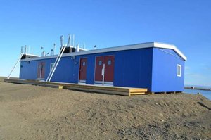
Station Nord was opened in 1952 as a Danish weather station and emergency runway, and it remained open until 1972, when it was closed and left unused, until the Danish military acquired it in 1975. The research activities at Station Nord have been ongoing since the 1970s with measurement activities being intensified since 1990. The research facilities were established by the Danish National Environmental Research Institute (NERI), which is now merged with Aarhus University. In 2014, the research facilities at Station Nord were substantially upgraded based on a major grant from the Danish private fund, Villum Foundation. VRS now consists of three buildings, including a main building with laboratories and accommodation facilities, an atmospheric/air observatory situated two km outside Station Nord, and a garage with storage facilities. The station can house 14 scientists at a time. The total area under roof is c. 600 m2.

General research and databases

Once the new station is fully operating, a database will be established for storage of all kind of scientific data. At present only atmospheric data are stored in a database maintained by Aarhus University. Meteorological and atmospheric chemical data are reported to EMEP (European Monitoring and Evaluation Programme), and AMAP (Arctic Monitoring and Assessment Programme) and will in the future also be reported to WMO-GAW (World Meteorological Organisation, Global Atmosphere Watch). A list of the parameters currently being measured at Station Nord can be found on http://envs.au.dk/en/research/facilities/villumresearchstation.

Station Monitoring

Human dimension

Station Nord is operated by the Danish military and is manned year round by five soldiers. The nearest Inuit community is situated more than 800 km away.

Access

Traditionally, transport to Station Nord has been with the Danish Air Force Hercules C-130 aircrafts on space-available conditions. From 2015, Aarhus University will arrange weekly flights between Longyearbyen, Svalbard, and Station Nord.

Member of: