Address

Suðurnes Science and Learning Center
Garðvegi 1
245 Sandgerði
Iceland

Station manager

Hanna María Kristjánsdóttir
E-mail: hanna@thekkingarsetur.is

Contact Station

Phone: +354 423 7555
E-mail: thekkingarsetur@thekkingarsetur.is

http://https//thekkingarsetur.is/english/

Station Features

Opening year: 2012 Status: Open
  • Type of station: Station
  • Operational period – year-round or Month A to Month B: Year-round
  • Name of station owner: Sudurnes Science and Learning Center
  • Type of owner: Government
  • Name of managing institution: Sudurnes Science and Learning Center
  • Managing Institution Country: Iceland
  • Station owner country: Iceland
  • Partner institution: Yes
  • Partner institution name: Southwest Iceland Nature Research Centre The University of Iceland´s Research Center in Sudurnes
  • Station latitude: 64,04101667
  • Station longitude: -22,71268889
  • Country (station location): Iceland
  • Altitude of station: 3 m a.s.l
  • Min. altitude within study area: 0 m a.s.l
  • Max. altitude within study area: 400 m a.s.l
  • Nearest town/settlement: Sandgerdi
  • Distance to nearest town/settlement: 0 km
  • Number of residents in nearest town: 1600
  • Distance to nearest public transport facility (Airport, Ferry terminal, Train station, Bus station): 7 km
  • Distance to nearest research station: 93 km
  • Maps available at station: Map (1:250 000), geological map, vegetation map, coastal habitat map, areal image, SPOT satellite image, Google Earth with high resolution
  • Climate zone: Sub-Arctic
  • Period of measurments for climate data below [year to year]: Since 1953 (for Keflavík airport)
  • Mean annual temperature: 4,7 °C
  • Mean temperature in February: 0,7 °C
  • Mean temperature in July: 10,6 °C
  • Precipitation type: Snow, Rain
  • Snow free period (month to month): April - September
  • Lake ice break up: April, May
  • Dominant wind direction: Southwest
  • Mean annual wind speed: 6,7 m/s
  • Maximum wind speed (absolute): 34,5 m/s
  • Landscape features Mountains, Lake, Sea
  • Permafrost zone None
  • Snow and ice on land None
  • Vegetation zone Peatlands, Wetlands
  • Human use Settlement

Facilities

  • Area under roof: 1470 m²
  • Max. number of visitors at a time : 17
  • Showers: Yes
  • Laundry facilities: Yes
  • Power supply – period (from ‘hour’ to ‘hour’ or 24 hours): 24 Hours
  • Power supply - plug type C, F
  • Power sources at station Water, Geothermal
  • Logistics area: 140 m²
  • Conference room capacity: 40
  • Workshops Metal, Plexiglas, Wood
  • Means of transportation to/from station Boat, Car, Other
  • Airstrip (Length × Width) : 3065 × 60 m
  • Airstrip surface : Tarmac/Concrete
  • Transport on land - at station Car
  • Water landing facilities Warf/pier
  • Number of staff peak season/summer: 12
  • Number of staff off season/winter: 9
  • Staff able to assist (workshops): 0
  • Laboratory area: 320 m²
  • Field to station Mobile phone
  • Station to outside world Mobile phone, Internet
  • IT Infrastructure Wifi, Computers, Printer
  • Medical facilities: Yes
  • Medical capability Medium
  • Distance to hospital (estimated time – hours): 9

Science

  • Arctic Council working groups
  • AMAP - Arctic Monitoring and Assessment Programme (Arctic), http://www.amap.no/
  • Transnational Access: Yes
  • Remote Access: Yes
  • INTERACT Virtual Access: No
  • Permitting issues categories
    • Permits required for access to the station
    • Permits required for studies
  • Partner institutions (involved in the operation of the station)
    • Partner institution
  • Climate
    • Snow
    • Rain
    • Hail
  • Housing and accomodation
    • Showers
    • Laundry facilities
    • A
    • B
    • C
    • D
    • E
    • F
    • G
    • H
    • I
    • J
    • K
    • L
    • M
    • N
    • O
    • Municipal grid
    • Diesel/oil/gas
    • Wood
    • Solar
    • Wind
    • Water
    • Geothermal
    • Biofuel
    • Other
  • Logistics
    • Electrical and IT technologies
    • Mechanical
    • Metal
    • Wood
    • Plexiglas
    • Other
    • Walk
    • None
    • Tracked vehicle
    • Truck
    • SUV (4x4)
    • Car
    • ATV
    • Zodiac
    • Snowmobile
    • Open boat/Dhinghy
    • Closed boat
    • Bicycles
    • Amphibie vehicle
    • Ski
    • Other
    • Snow shoes
    • KickSledges
    • Other
    • Ski
    • Snowmobile
    • Boat
    • Car
    • Tracked vehicle
    • Truck
    • SUV (4x4)
    • Bus
    • Train
    • Airstrip
    • Scheduled flight
    • Chartered plane/helicopter
    • Helipad
    • Other
    • None
    • Harbour/port
    • Warf/pier
    • Pontoon/float bridge
    • Barges
    • Beach
  • Aircraft landing facilities
    • Helipad
  • Features in the facility area
    • Permanent snowpatches
    • Mountain
    • Valley
    • Lake
    • River
    • Shoreline
    • Tree line
    • Polar deserts/semi-deserts
    • Shrub tundra
    • Gramminoid tundra
    • Forest tundra
    • Peatlands
    • Wetlands
    • Palsa mires
    • Deciduous forest
    • Evergreen forest
    • Human settlements or resource use in the area
    • Arable land
    • Other
  • Main science disciplines
    • Astronomy
    • Atmospheric sciences
    • Cryology
    • Geology
    • Hydrology
    • Limnic biology
    • Marine biology
    • Terrestrial biology
    • Human biology
    • Anthropology
    • Archaeology
    • Sociology
    • Climate change
    • Environmental science (incl. pollution)
    • Oceanography
    • Agriculture
    • Animal husbandry
    • Fisheries
    • Forestry
    • Hunting
    • Tourism
  • Workshop facilities
    • Metal workshop
    • Wood workshop
    • Plexiglas workshop
    • Staff available to assist with constructions
  • Communication
    • Telephone
    • Satellite phone
    • VHF
    • E-mail
    • Internet
    • Computer
    • Printer
    • Scanner
    • Fax
  • Meteorology
    • Air temperature
    • Air humidity
    • Air pressure
    • Wind velocity
    • Wind direction
    • Precipitation
  • Landscape and environment
    • Mountains
    • Nunataks
    • Volcano/crater
    • Lava fields
    • Plateaus
    • Moraines
    • Valleys
    • Homothermic Springs
    • Lake
    • Thermokarst lake
    • River
    • Delta/estuarie
    • Fjord
    • Continuous
    • Sea
    • Discontinuous
    • Beach
    • Sporadic
    • Rocky shores
    • Pingos/ice lenses
    • Sea cliffs
    • Other (text)
    • Palsa mires
    • None
    • Ice Caps
    • Glaciers
    • Permanent snow patches
    • None
    • Tree line
    • Polar desert/Semi-desert
    • Gramminoid tundra
    • Shrub tundra
    • Forest tundra
    • Wetlands
    • Peatlands/mires
    • Salt marshes/lagoons
    • Heath
    • Grassland
    • Deciduous forest
    • Evergreen forest
    • Terrestrial carnivores
    • Alpine heath
    • Ungulates
    • Hares
    • Other (text)
    • Rodents
    • Bird colonies
    • Polar bear
    • Whales
    • Seals
    • Fish
    • Settlement
    • Fishing
    • Hunting
    • Forestry
    • Agriculture
    • Tourism
    • Animal husbandry
    • Leisure activities
  • Laboratory
    • Freezer < -80
    • Freezer -40 - -10
    • Fridge
    • Microscopes
    • Basic laboratory equipment
    • Advanced laboratory equipment
    • Basic chemical reagents
    • Analytical instrumentation
    • Other
    • Laboratory available in nearby town/settlement
  • Communication and IT
    • Mobile phone
    • VHF
    • Satellite phone
    • Other
    • Satellite phone
    • Mobile phone
    • Internet
    • Other
    • Wireless transfer of data from field site to station
    • Wifi
    • Computers
    • Printer
    • Data storage
    • Statistical tools
    • GIS tools
    • Other
  • Medical facilities
    • Medical facilities
    • Basic
    • Medium
    • Extensive
    • Dental
    • Surgery
    • Other
    • No
    • In peak season
    • When open

Station name and owner

Sudurnes Science and Learning Center is a non-profit organisation, partly financed and accredited by the Ministry of Education, Science, and Culture in Iceland.

Location

The Center is located by the Sandgerdi harbour (64°02'N, 22°42'W) on the western coast of the Reykjanes Peninsula, about 50 km west of the capital, Reykjavik. It is in close proximity to coastal areas of high natural value, listed in the Icelandic Nature Conservation Registry, and Important Bird Areas identified by BirdLife International.

Climate data

Grey colours are WMO Climate Normals including maximum and minimum values. Blue colours are individual years.

Climate data for the stations where extracted via Copernicus Climate Data Store, from the global gridded reanalysis product: ERA5 monthly averaged data on single levels from 1940 to present. Description and source code: Roemer J.K. 2023. https://doi.org/10.5281/zenodo.10214922 Data Source: Hersbach et al. 2023. Copernicus Climate Change Service (C3S) Climate Data Store (CDS), https://doi.org/10.24381/cds.f17050d7

Biodiversity and natural environment

Reykjanes Peninsula is situated in the maritime subarctic climate zone, on the rift between the Eurasian and the North American tectonic plates, where the mid-Atlantic Ridge rises above the ocean&rsquo;s surface. Geologically, the peninsula is young and characterized by volcanism and vast lava fields covered with moss heath vegetation, dominated by montane moss (Racomitrium lanuginosum). The coastal areas are wildlife-rich with rocky shores, sandy beaches, muddy flats, and sea cliffs as well as some dry grasslands and small freshwater lakes by the coast. A total of 196 bird species have been recorded in the area, including 61 nesting species and many migrant birds from Eurasia, Africa, and America.

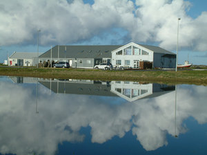
History and facilities

In 1992, an abandoned fish factory was turned into a research laboratory for the international, collaborative project Benthic Invertebrates of Icelandic Waters (BIOICE). Sudurnes Science and Learning Center was established in 2012. The Southwest Iceland Nature Research Centre (established 2000) and The University of Iceland’s Research Centre in Sudurnes (established 2004) are part of the Center. The Center has an excellent taxonomic laboratory, fish rearing and experimental facilities. It has three laboratories, three wet labs with clean borehole seawater, three meeting rooms, six bedrooms with 12 beds as well as kitchen, showers, and a laundry room. The facilities are ideal for conducting scientific studies in taxonomy, marine biology, ornithology, and general ecology. The Center offers the possibility to catch birds close by for in-house tests and measurements. Workshops are available in the village.

General research and databases

Sudurnes Science and Learning Center focuses on bird studies, marine invertebrates, and seashore ecology. The Center cooperates with the Icelandic Marine Research Institute utilizing automated analyses of zooplankton (ZooImage) for taxonomic purposes. Other studies are mainly on aquaculture animals such as the European lobster, arctic char, and cod, where the Center carries out its own projects and/or participates in service programmes using the facilities at the Center. The main focus of The University of Iceland´s Research Centre in Sudurnes is on research and teaching in marine biology and ecotoxicology, emphasizing on postgraduate students. The Southwest Iceland Nature Research Centre collects and stores information and data regarding the nature in the southwest region of Iceland. The main focus has been on ecological research, mainly on bird ecology and benthic invertebrates. The Nature Research Centre takes part in monitoring breeding success in seabirds in Iceland as well as monitoring migratory waders that go through the Sudurnes region. Climatic data are available for the area at The Icelandic Meteorological Office since 1953.

Station Monitoring

Human dimension

Sudurnes Science and Learning Center is located in Sandgerdi, a small fishing village with 1600 inhabitants. Fishing, service industries, and tourism are the primary occupations in the area.

Access

Sudurnes Science and Learning Center is easily accessible by car or bus throughout the year. It is located only 7 km from the international airport in Keflavik.

Member of: