Address

Rif Field Station
675 Raufarhöfn
Iceland

Station manager

Pedro Rodrigues
E-mail: pedro@rifresearch.is

Contact Station

Phone: +354 8569500
E-mail: rif@rifresearch.is

https://rifresearch.is/

Station Features

Opening year: 2014 Status: Open
  • Type of station: Station
  • Operational period – year-round or Month A to Month B: Year-round
  • Name of station owner: Rif Field Station
  • Type of owner: Research institution
  • Name of managing institution: Rif Field Station
  • Managing Institution Country: Iceland
  • Station owner country: Iceland
  • Partner institution: Yes
  • Partner institution name: Northeast Iceland Nature Research Centre, Iceland
  • Station latitude: 66,45621667
  • Station longitude: -15,95168333
  • Country (station location): Iceland
  • Altitude of station: 6 m a.s.l
  • Min. altitude within study area: 0 m a.s.l
  • Max. altitude within study area: 284 m a.s.l
  • Nearest town/settlement: Raufarhöfn
  • Distance to nearest town/settlement: 0 km
  • Number of residents in nearest town: 200
  • Distance to nearest public transport facility (Airport, Ferry terminal, Train station, Bus station): 141 km
  • Distance to nearest research station: 171 km
  • Maps available at station: Map 1:100 000; 1:250 000, aerial image, Google Earth
  • Climate zone: Sub-Arctic
  • Period of measurments for climate data below [year to year]: 2001-2008
  • Mean annual temperature: 3,4 °C
  • Mean temperature in February: -0,7 °C
  • Mean temperature in July: 9,1 °C
  • Precipitation type: Snow, Rain
  • Lake ice break up: April, May
  • Mean annual wind speed: 6,5 m/s
  • Maximum wind speed (absolute): 29,9 m/s
  • Landscape features Mountains, Lake, River, Sea
  • Permafrost zone None
  • Vegetation zone Peatlands, Wetlands
  • Human use Settlement

Facilities

  • Area under roof: 66 m²
  • Max. number of visitors at a time : 8
  • Showers: Yes
  • Laundry facilities: Yes
  • Power supply – period (from ‘hour’ to ‘hour’ or 24 hours): 24 Hours
  • Power supply - plug type C, F
  • Logistics area: 0 m²
  • Means of transportation to/from station Car
  • Air transport landing facilities at station None
  • Airstrip (Length × Width) : Airports: Þórshöfn (67 km), Húsavík (130 km), Akureyri (222 km)
  • Number of staff peak season/summer: 1
  • Number of staff off season/winter: 1
  • Staff able to assist (fieldwork): Yes - if time allows
  • Staff able to assist (workshops): Yes - if time allows
  • Compulsory safety equipment Other
  • Recommended safety equipment ,303
  • Laboratory area: 15 m²
  • Field to station Mobile phone
  • Station to outside world Mobile phone, Internet
  • IT Infrastructure Wifi
  • Distance to hospital (estimated time – hours): 130

Science

  • Transnational Access: Yes
  • Remote Access: Yes
  • INTERACT Virtual Access: No
  • Permitting issues categories
    • Permits required for access to the station
    • Permits required for studies
  • Partner institutions (involved in the operation of the station)
    • Partner institution
  • Climate
    • Snow
    • Rain
    • Hail
  • Housing and accomodation
    • Showers
    • Laundry facilities
    • A
    • B
    • C
    • D
    • E
    • F
    • G
    • H
    • I
    • J
    • K
    • L
    • M
    • N
    • O
    • Municipal grid
    • Diesel/oil/gas
    • Wood
    • Solar
    • Wind
    • Water
    • Geothermal
    • Biofuel
    • Other
  • Logistics
    • Electrical and IT technologies
    • Mechanical
    • Metal
    • Wood
    • Plexiglas
    • Other
    • Walk
    • None
    • Tracked vehicle
    • Truck
    • SUV (4x4)
    • Car
    • ATV
    • Zodiac
    • Snowmobile
    • Open boat/Dhinghy
    • Closed boat
    • Bicycles
    • Amphibie vehicle
    • Ski
    • Other
    • Snow shoes
    • KickSledges
    • Other
    • Ski
    • Snowmobile
    • Boat
    • Car
    • Tracked vehicle
    • Truck
    • SUV (4x4)
    • Bus
    • Train
    • Airstrip
    • Scheduled flight
    • Chartered plane/helicopter
    • Helipad
    • Other
    • None
    • Harbour/port
    • Warf/pier
    • Pontoon/float bridge
    • Barges
    • Beach
  • Aircraft landing facilities
    • Helipad
  • Features in the facility area
    • Permanent snowpatches
    • Mountain
    • Valley
    • Lake
    • River
    • Shoreline
    • Tree line
    • Polar deserts/semi-deserts
    • Shrub tundra
    • Gramminoid tundra
    • Forest tundra
    • Peatlands
    • Wetlands
    • Palsa mires
    • Deciduous forest
    • Evergreen forest
    • Human settlements or resource use in the area
    • Arable land
    • Other
  • Main science disciplines
    • Astronomy
    • Atmospheric sciences
    • Cryology
    • Geology
    • Hydrology
    • Limnic biology
    • Marine biology
    • Terrestrial biology
    • Human biology
    • Anthropology
    • Archaeology
    • Sociology
    • Climate change
    • Environmental science (incl. pollution)
    • Oceanography
    • Agriculture
    • Animal husbandry
    • Fisheries
    • Forestry
    • Hunting
    • Tourism
  • Workshop facilities
    • Metal workshop
    • Wood workshop
    • Plexiglas workshop
    • Staff available to assist with constructions
  • Communication
    • Telephone
    • Satellite phone
    • VHF
    • E-mail
    • Internet
    • Computer
    • Printer
    • Scanner
    • Fax
  • Meteorology
    • Air temperature
    • Air humidity
    • Air pressure
    • Wind velocity
    • Wind direction
    • Precipitation
  • Geophysics and Geodesy
    • Gravity
    • Magnetic field
    • Aurora
    • Seismic activity
  • Sub-surface characteristics
    • Ground surface temperature
    • Soil temperature
    • Soil moisture
    • Ground water table
    • Soil water chemistry
    • Active layer depth
    • Permafrost distribution
    • Permafrost thickness
    • Permafrost temperature
  • Energy balance and radiation
    • Energy balance
    • Short wave incoming
    • Short wave outgoing
    • Long wave incoming
    • Long wave outgoing
    • Net radiation
    • UV-B
    • Multi-spectral
    • Cloud cover/hours of sunshine
  • Hydrology/Limnology
    • River water discharge/water level
    • Lake water level
    • Water balance
    • Water temperature
    • Lake ice cover (formation/breakup/thickness)
    • Suspended sediment discharge
    • Organic matter discharge
    • PAR (Photosyntetically Active Radiation)/secchi depth
    • Water chemistry
  • Particles and aerosols
    • Particles and aerosols
  • Vegetation
    • Flowering phenology
    • Amount of flowering
    • NDVI (plot/transect)
    • Landscape NDVI (from satellite images)
    • Vascular plant community composition
    • Bryophyte community composition
    • Lichen community composition
    • Fungi community composition
    • Berry production
    • Aerobiological monitoring (pollen, spores, etc.)
    • Species list (community composition)
  • Arthropods
    • Abundance
    • Emergence phenology
    • Insect herbivory
    • Species list (community composition)
  • Mammals
    • Mammal abundance
    • Mammal distribution
    • Mammal reproduction
    • Mortality
    • Predation
    • Physiology
    • Species list (community composition)
  • Lake ecology
    • Phytoplankton (including chlorophyll)
    • Zooplankton
    • Vegetation
    • Fish
    • Invertebrates
    • Species list (community composition)
  • Landscape and environment
    • Mountains
    • Nunataks
    • Volcano/crater
    • Lava fields
    • Plateaus
    • Moraines
    • Valleys
    • Homothermic Springs
    • Lake
    • Thermokarst lake
    • River
    • Delta/estuarie
    • Fjord
    • Sea
    • Continuous
    • Discontinuous
    • Beach
    • Sporadic
    • Rocky shores
    • Pingos/ice lenses
    • Sea cliffs
    • Other (text)
    • Palsa mires
    • None
    • Ice Caps
    • Glaciers
    • Permanent snow patches
    • None
    • Tree line
    • Polar desert/Semi-desert
    • Gramminoid tundra
    • Shrub tundra
    • Forest tundra
    • Wetlands
    • Peatlands/mires
    • Salt marshes/lagoons
    • Heath
    • Grassland
    • Deciduous forest
    • Evergreen forest
    • Terrestrial carnivores
    • Alpine heath
    • Ungulates
    • Hares
    • Other (text)
    • Rodents
    • Bird colonies
    • Polar bear
    • Whales
    • Seals
    • Fish
    • Settlement
    • Fishing
    • Hunting
    • Forestry
    • Agriculture
    • Tourism
    • Animal husbandry
    • Leisure activities
  • Field equipment
    • PLB
    • VHF
    • HF
    • Satellite phone
    • Mobile phone
    • GPS
    • Weapon/rifle
    • Flare gun
    • Bearspray
    • PLB
    • First aid kit
    • Glacier rescue kit
    • VHF
    • Avalanche rescue kit
    • HF
    • Satellite phone
    • Overnight equipment
    • Other
    • Mobile phone
    • GPS
    • Weapon/rifle
    • Flare gun
    • Bearspray
    • PLB
    • First aid kit
    • Glacier rescue kit
    • VHF
    • Avalanche rescue kit
    • HF
    • Satellite phone
    • Overnight equipment
    • Other
    • Mobile phone
    • GPS
    • Weapon/rifle
    • Flare gun
    • Bearspray
    • Tent
    • First aid kit
    • Glacier rescue kit
    • Sleeping matress
    • Avalanche rescue kit
    • Sleeping bag
    • Cooking equipment and utensils
    • Overnight equipment
    • Other
    • Gas/alcohol for cooking
    • Field power supply available at station
  • Laboratory
    • Freezer < -80
    • Freezer -40 - -10
    • Fridge
    • Microscopes
    • Basic laboratory equipment
    • Advanced laboratory equipment
    • Basic chemical reagents
    • Analytical instrumentation
    • Other
    • Laboratory available in nearby town/settlement
  • Communication and IT
    • Mobile phone
    • VHF
    • Satellite phone
    • Other
    • Satellite phone
    • Mobile phone
    • Internet
    • Other
    • Wireless transfer of data from field site to station
    • Wifi
    • Computers
    • Printer
    • Data storage
    • Statistical tools
    • GIS tools
    • Other
  • Medical facilities
    • Medical facilities
    • Basic
    • Medium
    • Extensive
    • Dental
    • Surgery
    • Other
    • No
    • In peak season
    • When open

Station name and owner

The Rif Field Station is is administrated by Northeast Iceland Nature Research Centre, and it is named after the peninsula of Rif, in the northernmost part of Iceland.

Location

The station is located in Raufarhöfn, a small village on the northeast coast of the Melrakkaslétta peninsula in Northeast Iceland. The peninsula is the northernmost lowland area in Iceland, only 3 km south of the Arctic Circle. The northern part of the peninsula is an important area for conservation, especially as a habitat for many bird species. The area has no protection status according to the Nature Conservation Act, but is listed as an internationally Important Bird Area (IBA) by BirdLife International. Most of the area is privately owned but some of the abandoned farms are owned by the Government of Iceland.

Climate data

Grey colours are WMO Climate Normals including maximum and minimum values. Blue colours are individual years.

Climate data for the stations where extracted via Copernicus Climate Data Store, from the global gridded reanalysis product: ERA5 monthly averaged data on single levels from 1940 to present. Description and source code: Roemer J.K. 2023. https://doi.org/10.5281/zenodo.10214922 Data Source: Hersbach et al. 2023. Copernicus Climate Change Service (C3S) Climate Data Store (CDS), https://doi.org/10.24381/cds.f17050d7

Biodiversity and natural environment

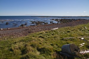
The northern coast of Melrakkaslétta is highly exposed to cold northerly winds. Fog is frequent along the coast. The coast is characterized by algae rich gentle sloping gravel banks with numerous open and land-locked bays, inlets, salt marshes, and brackish lagoons. Low average summer temperature and high humidity affect the vegetation in the area, and plants of arctic origin are characteristic for the area. At least 53 species of birds have been found breeding in the area, and seabirds, waterfowl, and waders occur frequently in the area. Rock ptarmigan and purple sandpiper are found breeding in high densities. The shores of Melrakkaslétta are used by locally breeding birds as well as up to 20000 arctic waders on their way to the breeding grounds in Greenland and arctic Canada.

History and facilities

Rif Field Station was established in 2014. The station is currently housed in a three-floor building, partly run as a guesthouse. Accommodation facilities include two bedrooms, a kitchen, a living room, and a bathroom. It is available for 6-8 persons at a time. Laboratory and storage facilities are located in the basement. Accommodation for larger groups can be provided in a nearby guesthouse. In Raufarhöfn there is a grocery store, a hotel, a restaurant, a coffee shop, a bank, a post office, a health care centre, and a swimming pool. The station has unlimited access to the land of Rif, the northernmost part of Iceland, for scientific purposes.

General research and databases

The Rif Field Station is in its development stage. Research will include basic monitoring projects on weather/Climate Change, vegetation, and birds. Long-term research will be conducted on arctic species like rock ptarmigan, gyrfalcon, arctic tern, and purple sandpiper as well as on high arctic migratory birds. Data on climate dates back to 1920. Arrival dates for different bird species has been registered since 2001.

Station Monitoring

Human dimension

For centuries sheep farming was practiced along the northern coast of Melrakkaslétta, supplemented with some small scale fishing by farmers, both at sea and in freshwater lakes. Farmers also benefitted from the large amount of driftwood that washed up on the shore. Today most of these farms have been abandoned, although some are still used as summer houses. . The village of Raufarhöfn (180 inhabitants), with its great natural harbour, was established for fishery, and eider down is still collected in large eider colonies.

Access

Raufarhöfn is easily accessible by car, on paved road all the way from Reykjavík. The nearest domestic airports are at Þórshöfn (67 km), Húsavík (130 km), and Akureyri (222 km). Eagle Air operates flights from Reykjavík to Húsavík, and Air Iceland from Reykjavík to Akureyri. Norlandair operates flights between Akureyri and Þórshöfn. A limited scheduled bus service is available between Akureyri, Húsavík, and Raufarhöfn.

Member of: