Address

The Sornfelli Meteorological Station
The Faroese Geological Survey
Brekkutún 1
Hoyvík
Faroe Islands

Station manager

Lis Mortensenlm​@jf.fo">E-mail
Phone: +298 35 7000
Fax: +298 357001
E-mail: lm@jf.fo

Contact Station

Phone: +298 35 7000
E-mail: jardfeingi@jardfeingi.fo

https://jf.fo/en

Station Features

Opening year: 1999 Status: Open
  • Type of station: Station
  • Operational period – year-round or Month A to Month B: Year-round
  • Name of station owner: Jarðfeingi and partners
  • Type of owner: Government
  • Name of managing institution: Jarðfeingi and partners
  • Managing Institution Country: Faroe Islands
  • Station owner country: Faroe Islands
  • Partner institution: No
  • Station latitude: 62,06666667
  • Station longitude: -6,96666667
  • Country (station location): Faroe Islands
  • Altitude of station: 725 m a.s.l
  • Min. altitude within study area: 0 m a.s.l
  • Max. altitude within study area: 882 m a.s.l
  • Nearest town/settlement: Tórshavn
  • Distance to nearest town/settlement: 15 km
  • Number of residents in nearest town: 18000
  • Distance to nearest public transport facility (Airport, Ferry terminal, Train station, Bus station): 15 km
  • Distance to nearest research station: 490 km
  • Maps available at station: Map (1:20 000 and 1:100 000 ), aerial image, satellite image, Google Earth
  • Climate zone: Sub-Arctic
  • Period of measurments for climate data below [year to year]:
  • Mean annual temperature: 6,5 °C
  • Mean temperature in February: 3,6 °C
  • Mean temperature in July: 10,3 °C
  • Precipitation type: Snow, Rain, Hail
  • Dominant wind direction: Southwest
  • Mean annual wind speed: 5,9 m/s
  • Maximum wind speed (absolute): 43,2 m/s
  • Landscape features Mountains, Valleys, Sea
  • Permafrost zone None

Facilities

  • Area under roof: 0 m²
  • Max. number of visitors at a time : 20
  • Showers: No
  • Laundry facilities: No
  • Power supply – period (from ‘hour’ to ‘hour’ or 24 hours): 24 Hours
  • Power supply - plug type C, E, F, K
  • Logistics area: 50 m²
  • Workshops Wood
  • Means of transportation to/from station Car
  • Airstrip (Length × Width) :
  • Transport on land - at station Car
  • Number of staff peak season/summer: 1
  • Number of staff off season/winter: 1
  • Laboratory area: 30 m²
  • Field to station Mobile phone, VHF
  • Station to outside world Mobile phone, Internet
  • IT Infrastructure Wifi, Computers, Printer, Other
  • Distance to hospital (estimated time – hours): 15

Science

  • Transnational Access: Yes
  • Remote Access: Yes
  • INTERACT Virtual Access: Yes
  • Permitting issues categories
    • Permits required for access to the station
    • Permits required for studies
  • Partner institutions (involved in the operation of the station)
    • Partner institution
  • Climate
    • Snow
    • Rain
    • Hail
  • Housing and accomodation
    • Showers
    • Laundry facilities
    • A
    • B
    • C
    • D
    • E
    • F
    • G
    • H
    • I
    • J
    • K
    • L
    • M
    • N
    • O
    • Municipal grid
    • Diesel/oil/gas
    • Wood
    • Solar
    • Wind
    • Water
    • Geothermal
    • Biofuel
    • Other
  • Logistics
    • Electrical and IT technologies
    • Mechanical
    • Metal
    • Wood
    • Plexiglas
    • Other
    • Walk
    • None
    • Tracked vehicle
    • Truck
    • SUV (4x4)
    • Car
    • ATV
    • Zodiac
    • Snowmobile
    • Open boat/Dhinghy
    • Closed boat
    • Bicycles
    • Amphibie vehicle
    • Ski
    • Other
    • Snow shoes
    • KickSledges
    • Other
    • Ski
    • Snowmobile
    • Boat
    • Car
    • Tracked vehicle
    • Truck
    • SUV (4x4)
    • Bus
    • Train
    • Airstrip
    • Scheduled flight
    • Chartered plane/helicopter
    • Helipad
    • Other
    • None
    • Harbour/port
    • Warf/pier
    • Pontoon/float bridge
    • Barges
    • Beach
  • Aircraft landing facilities
    • Helipad
  • Features in the facility area
    • Permanent snowpatches
    • Mountain
    • Valley
    • Lake
    • River
    • Shoreline
    • Tree line
    • Polar deserts/semi-deserts
    • Shrub tundra
    • Gramminoid tundra
    • Forest tundra
    • Peatlands
    • Wetlands
    • Palsa mires
    • Deciduous forest
    • Evergreen forest
    • Human settlements or resource use in the area
    • Arable land
    • Other
  • Main science disciplines
    • Astronomy
    • Atmospheric sciences
    • Cryology
    • Geology
    • Hydrology
    • Limnic biology
    • Marine biology
    • Terrestrial biology
    • Human biology
    • Anthropology
    • Archaeology
    • Sociology
    • Climate change
    • Environmental science (incl. pollution)
    • Oceanography
    • Agriculture
    • Animal husbandry
    • Fisheries
    • Forestry
    • Hunting
    • Tourism
  • Workshop facilities
    • Metal workshop
    • Wood workshop
    • Plexiglas workshop
    • Staff available to assist with constructions
  • Communication
    • Telephone
    • Satellite phone
    • VHF
    • E-mail
    • Internet
    • Computer
    • Printer
    • Scanner
    • Fax
  • Landscape and environment
    • Mountains
    • Nunataks
    • Volcano/crater
    • Lava fields
    • Plateaus
    • Moraines
    • Valleys
    • Homothermic Springs
    • Lake
    • Thermokarst lake
    • River
    • Delta/estuarie
    • Fjord
    • Sea
    • Continuous
    • Discontinuous
    • Beach
    • Sporadic
    • Rocky shores
    • Pingos/ice lenses
    • Sea cliffs
    • Other (text)
    • Palsa mires
    • None
    • Ice Caps
    • Glaciers
    • Permanent snow patches
    • None
    • Tree line
    • Polar desert/Semi-desert
    • Gramminoid tundra
    • Shrub tundra
    • Forest tundra
    • Wetlands
    • Peatlands/mires
    • Salt marshes/lagoons
    • Heath
    • Grassland
    • Deciduous forest
    • Evergreen forest
    • Terrestrial carnivores
    • Alpine heath
    • Ungulates
    • Hares
    • Other (text)
    • Rodents
    • Bird colonies
    • Polar bear
    • Whales
    • Seals
    • Fish
    • Settlement
    • Fishing
    • Hunting
    • Forestry
    • Agriculture
    • Tourism
    • Animal husbandry
    • Leisure activities
  • Laboratory
    • Freezer < -80
    • Freezer -40 - -10
    • Fridge
    • Microscopes
    • Basic laboratory equipment
    • Advanced laboratory equipment
    • Basic chemical reagents
    • Analytical instrumentation
    • Other
    • Laboratory available in nearby town/settlement
  • Communication and IT
    • Mobile phone
    • VHF
    • Satellite phone
    • Other
    • Satellite phone
    • Mobile phone
    • Internet
    • Other
    • Wireless transfer of data from field site to station
    • Wifi
    • Computers
    • Printer
    • Data storage
    • Statistical tools
    • GIS tools
    • Other
  • Medical facilities
    • Medical facilities
    • Basic
    • Medium
    • Extensive
    • Dental
    • Surgery
    • Other
    • No
    • In peak season
    • When open

Station name and owner

The Faroe Islands Nature Investigation (FINI) belongs to Jar&eth;feingi (Faroese Earth and Energy Directorate) and partners.

Location

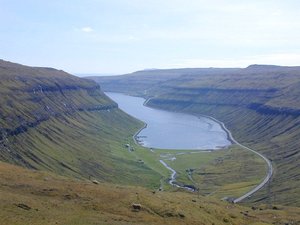
FINI comprises a growing number of monitoring sites placed on public and private land in the Faroe Islands. The 18 islands form a self-governing country under the sovereignty of the Kingdom of Denmark. The total area is approximately 1400 km2 and has a population of almost 50000 people (2010). The monitoring sites are placed on mountain slopes and summits that are accessible within an hour hike from the road and within an hour drive by car from the capital Tórshavn.

Climate data

Grey colours are WMO Climate Normals including maximum and minimum values. Blue colours are individual years.

Climate data for the stations where extracted via Copernicus Climate Data Store, from the global gridded reanalysis product: ERA5 monthly averaged data on single levels from 1940 to present. Description and source code: Roemer J.K. 2023. https://doi.org/10.5281/zenodo.10214922 Data Source: Hersbach et al. 2023. Copernicus Climate Change Service (C3S) Climate Data Store (CDS), https://doi.org/10.24381/cds.f17050d7

Biodiversity and natural environment

The Faroe Islands are a group of islands situated between the Norwegian Sea and the northeast Atlantic Ocean with more than 300 km distance to the next land area (approximately half way between Scotland and Iceland). The islands have an oceanic subarctic climate and are characterised by a high relief. The mountain areas are heavily grazed by sheep. The floral and faunal biodiversity is low, reflecting the isolated location, the extreme oceanic climate, the steep topography, and intensive land use. The most dominant vegetation in the Faroe Islands is grassland, found from sea level to the mountain tops. Racomitrium heaths and fell-field vegetation dominate the alpine vegetation. Calluna heaths are common in the lowlands. Birds dominate the terrestrial wild life.

History and facilities

Most of the monitoring sites of FINI are less than 10 years old. FINI has no station facilities at the sites, but can offer office facilities including internet access, other logistic support, and advice at FINI, Jarðfeingi, in Tórshavn.

General research and databases

The research at the FINI sites focuses on geohazards, meteorology, geophysics, and plant ecology. The existing database includes a bibliography of publications based on monitoring data.

Link to data: https://dataportal.eu-interact.org/stations

Station Monitoring

Human dimension

People in towns and villages live a modern European life. Houses are modern, the infrastructure is well developed and it is easy to travel by car. At the same time rich elements of traditional Faroese culture are deeply rooted in daily life: fishing, bird and whale hunting, traditional food and singing, and chain dancing. The language is Faroese which has close roots in the Old Norse language.

Access

You can arrive to the Faroe Islands all year by ship or by plane. The ferry leaves from Hanstholm, Denmark and Seyðisfjørður, Iceland. Look for www.smyrilline.com. Flight connections to the Faroe Islands leave from Copenhagen (Denmark), Aalborg (Denmark), Billund (Denmark), Reykjavik (Iceland), Bergen (Norway), London (UK) and Barcelona (Spain). Look for www.atlantic.fo. The local infrastructure in the Faroe Islands is well developed with busses and ferries. It is also possible to rent cars and helicopter routes are fairly cheap. Look for www.visitfaroeislands.fo.

Member of: