Address

Petuniabukta
Billefjorden
Svalbard
Norway

Station manager

Krzysztof Rymer
E-mail: krym@amu.edu.pl

Contact Station

Phone: +48 618296189
E-mail: svalbard@amu.edu.pl

www.polar.amu.edu.pl

Station Features

Opening year: 2011 Status: Open
  • Type of station: Station
  • Operational period – year-round or Month A to Month B: July-September
  • Name of station owner: Adam Mickiewicz University in Poznan, Poland
  • Type of owner: Research institution
  • Name of managing institution: Adam Mickiewicz University in Poznan, Faculty of Geographical and Geological Sciences
  • Managing Institution Country: Poland
  • Station owner country: Poland
  • Partner institution: No
  • Station latitude: 78,68043321
  • Station longitude: 16,45465962
  • Country (station location): Svalbard and Jan Mayen Islands
  • Altitude of station: 2 m a.s.l
  • Min. altitude within study area: 0 m a.s.l
  • Max. altitude within study area: 1127 m a.s.l
  • Nearest town/settlement: Pyramiden (6 inhabitants in 2018); Longyearbyen (2144 inhabitants in 2015)
  • Distance to nearest town/settlement: 4 km
  • Number of residents in nearest town: 0
  • Distance to nearest public transport facility (Airport, Ferry terminal, Train station, Bus station): 60 km
  • Distance to nearest research station: 0,01 km
  • Maps available at station: Maps (1:40000; 1:100000), aerial image, satellite image, GoogleEarth
  • Type of surface facility is built on: Soft substrate
  • Climate zone: High Arctic
  • Period of measurments for climate data below [year to year]: In Petuniabukta since 2000 with gaps, calibrated against longterm data series from Longyearbyen (since 1912)
  • Mean annual temperature: -6 °C
  • Mean temperature in February: -12 °C
  • Mean temperature in July: 7,5 °C
  • Precipitation type: Snow, Rain
  • Sea ice break up: July
  • Lake ice break up: July
  • Dominant wind direction: South
  • Mean annual wind speed: 4 m/s
  • Maximum wind speed (absolute): 24 m/s
  • Landscape features Mountains, Valleys, Lake, River, Sea
  • Permafrost zone Continuous
  • Snow and ice on land Ice Caps, Glaciers, Permanent snow patches
  • Vegetation zone Polar desert/Semi-desert, Shrub tundra, Gramminoid tundra
  • Human use Settlement

Facilities

  • Area under roof: 78 m²
  • Max. number of visitors at a time : 10
  • Showers: No
  • Laundry facilities: No
  • Power supply – period (from ‘hour’ to ‘hour’ or 24 hours): Constant
  • Power supply - plug type C
  • Power sources at station Diesel/oil/gas, Other, Solar
  • Number of staff peak season/summer: 2
  • Number of staff off season/winter: 0
  • Staff able to assist (fieldwork): Yes - if time allows
  • Staff able to assist (workshops): Yes - if time allows
  • Logistics area: 40 m²
  • Conference room capacity: 10
  • Means of transportation to/from station Boat
  • Air transport landing facilities at station None
  • Transport on water - at station Zodiac
  • Water landing facilities None
  • Compulsory safety equipment VHF, Weapon/rifle, Flare gun
  • Recommended safety equipment PLB, Satellite phone, Other, GPS, Glacier rescue kit
  • Safety equipment available at station VHF, GPS, Flare gun, Overnight equipment, Other
  • Camping equipment available at station Tent, Sleeping matress, Sleeping bag, Cooking equipment and utensils, Gas/alcohol for cooking
  • Field instruments available at station: GPS, GPR, drilling equipment (shallow sediment and ice boreholes), automatic weather stations, basic laboratory equipment
  • Laboratory area: 10 m²
  • Field to station VHF
  • Station to outside world Other, Internet
  • IT Infrastructure Computers
  • Distance to hospital (estimated time – hours): 1

Science

  • Transnational Access: Yes
  • Remote Access: No
  • INTERACT Virtual Access: No
  • Climate
    • Snow
    • Rain
    • Hail
  • Features in the facility area
    • Permanent snowpatches
    • Mountain
    • Valley
    • Lake
    • River
    • Shoreline
    • Tree line
    • Polar deserts/semi-deserts
    • Shrub tundra
    • Gramminoid tundra
    • Forest tundra
    • Peatlands
    • Wetlands
    • Palsa mires
    • Deciduous forest
    • Evergreen forest
    • Human settlements or resource use in the area
    • Arable land
    • Other
  • Main science disciplines
    • Astronomy
    • Atmospheric sciences
    • Cryology
    • Geology
    • Hydrology
    • Limnic biology
    • Marine biology
    • Terrestrial biology
    • Human biology
    • Anthropology
    • Archaeology
    • Sociology
    • Climate change
    • Environmental science (incl. pollution)
    • Oceanography
    • Agriculture
    • Animal husbandry
    • Fisheries
    • Forestry
    • Hunting
    • Tourism
  • Housing and accomodation
    • Showers
    • Laundry facilities
    • A
    • B
    • C
    • D
    • E
    • F
    • G
    • H
    • I
    • J
    • K
    • L
    • M
    • N
    • O
    • Municipal grid
    • Diesel/oil/gas
    • Wood
    • Solar
    • Wind
    • Water
    • Geothermal
    • Biofuel
    • Other
  • Workshop facilities
    • Metal workshop
    • Wood workshop
    • Plexiglas workshop
    • Staff available to assist with constructions
  • Communication
    • Telephone
    • Satellite phone
    • VHF
    • E-mail
    • Internet
    • Computer
    • Printer
    • Scanner
    • Fax
  • Aircraft landing facilities
    • Helipad
  • Permitting issues categories
    • Permits required for studies
    • Permits required for access to the station
  • Meteorology
    • Air temperature
    • Air humidity
    • Air pressure
    • Wind velocity
    • Wind direction
    • Precipitation
  • Energy balance and radiation
    • Energy balance
    • Short wave incoming
    • Short wave outgoing
    • Long wave incoming
    • Long wave outgoing
    • Net radiation
    • UV-B
    • Multi-spectral
    • Cloud cover/hours of sunshine
  • Geology/Geomorphology
    • Quaternary geology
    • Sedimentology
    • Bedrock geology
    • Erosion
  • Sub-surface characteristics
    • Ground surface temperature
    • Soil temperature
    • Soil moisture
    • Ground water table
    • Soil water chemistry
    • Active layer depth
    • Permafrost distribution
    • Permafrost thickness
    • Permafrost temperature
  • Hydrology/Limnology
    • River water discharge/water level
    • Lake water level
    • Water balance
    • Water temperature
    • Lake ice cover (formation/breakup/thickness)
    • Suspended sediment discharge
    • Organic matter discharge
    • PAR (Photosyntetically Active Radiation)/secchi depth
    • Water chemistry
  • Glacier characteristics
    • Glacier area
    • Topography
    • Elevation change
    • Terminus position
    • Ice velocity
    • Ice thickness
    • Debris cover
    • Surface albedo/reflexion coefficient
  • Mass balace
    • Mass balance
    • Snow water equivalent
    • Snowcover stratigraphy
    • Equilibrium Line Altitude
    • Duration of snow cover
    • Calving flux
  • Climate
    • Climate measurements
    • Energy balance
  • Glacier hydrology
    • Run-off
    • Supra-, en- and subglacial drainage system
    • Meltwater retention
    • Glacial lake outburst floods
  • Vegetation
    • Flowering phenology
    • Amount of flowering
    • NDVI (plot/transect)
    • Landscape NDVI (from satellite images)
    • Vascular plant community composition
    • Bryophyte community composition
    • Lichen community composition
    • Fungi community composition
    • Berry production
    • Aerobiological monitoring (pollen, spores, etc.)
    • Species list (community composition)
  • Socio-ecological issues (disturbance)
    • Number of visitors
    • Surface activities (e.g. removal of vegetation, organisms, soil samples, ATV traffic, manipulations)
    • Aircraft activities
    • Emissions/discharge energy consumption, spill water, waste, garbage, atmospheric emissions, etc.)
  • Partner institutions (involved in the operation of the station)
    • Partner institution
  • Landscape and environment
    • Mountains
    • Nunataks
    • Volcano/crater
    • Lava fields
    • Plateaus
    • Moraines
    • Valleys
    • Homothermic Springs
    • Lake
    • Thermokarst lake
    • River
    • Delta/estuarie
    • Fjord
    • Sea
    • Continuous
    • Discontinuous
    • Beach
    • Sporadic
    • Rocky shores
    • Pingos/ice lenses
    • Sea cliffs
    • Other (text)
    • Palsa mires
    • Ice Caps
    • None
    • Glaciers
    • Permanent snow patches
    • None
    • Tree line
    • Polar desert/Semi-desert
    • Gramminoid tundra
    • Shrub tundra
    • Forest tundra
    • Wetlands
    • Peatlands/mires
    • Salt marshes/lagoons
    • Heath
    • Grassland
    • Deciduous forest
    • Evergreen forest
    • Terrestrial carnivores
    • Alpine heath
    • Ungulates
    • Hares
    • Other (text)
    • Rodents
    • Bird colonies
    • Polar bear
    • Whales
    • Seals
    • Fish
    • Settlement
    • Fishing
    • Hunting
    • Forestry
    • Agriculture
    • Tourism
    • Animal husbandry
    • Leisure activities
  • Logistics
    • Electrical and IT technologies
    • Mechanical
    • Metal
    • Wood
    • Plexiglas
    • Other
    • Walk
    • None
    • Tracked vehicle
    • Truck
    • SUV (4x4)
    • Car
    • Zodiac
    • ATV
    • Snowmobile
    • Open boat/Dhinghy
    • Closed boat
    • Bicycles
    • Amphibie vehicle
    • Ski
    • Other
    • Snow shoes
    • KickSledges
    • Other
    • Ski
    • Snowmobile
    • Boat
    • Car
    • Tracked vehicle
    • Truck
    • SUV (4x4)
    • Bus
    • Train
    • Airstrip
    • Scheduled flight
    • Helipad
    • Chartered plane/helicopter
    • None
    • Other
    • Harbour/port
    • Warf/pier
    • Pontoon/float bridge
    • Barges
    • Beach
  • Field equipment
    • PLB
    • VHF
    • HF
    • Satellite phone
    • Mobile phone
    • GPS
    • Weapon/rifle
    • Flare gun
    • Bearspray
    • PLB
    • First aid kit
    • Glacier rescue kit
    • VHF
    • Avalanche rescue kit
    • HF
    • Satellite phone
    • Overnight equipment
    • Other
    • Mobile phone
    • GPS
    • Weapon/rifle
    • Flare gun
    • Bearspray
    • PLB
    • First aid kit
    • VHF
    • Glacier rescue kit
    • Avalanche rescue kit
    • HF
    • Satellite phone
    • Overnight equipment
    • Other
    • Mobile phone
    • GPS
    • Weapon/rifle
    • Flare gun
    • Bearspray
    • Tent
    • First aid kit
    • Sleeping matress
    • Glacier rescue kit
    • Sleeping bag
    • Avalanche rescue kit
    • Cooking equipment and utensils
    • Overnight equipment
    • Other
    • Gas/alcohol for cooking
    • Field power supply available at station
  • Laboratory
    • Freezer < -80
    • Freezer -40 - -10
    • Fridge
    • Microscopes
    • Basic laboratory equipment
    • Advanced laboratory equipment
    • Basic chemical reagents
    • Analytical instrumentation
    • Other
    • Laboratory available in nearby town/settlement
  • Communication and IT
    • Mobile phone
    • VHF
    • Satellite phone
    • Satellite phone
    • Other
    • Mobile phone
    • Internet
    • Other
    • Wireless transfer of data from field site to station
    • Wifi
    • Computers
    • Printer
    • Data storage
    • Statistical tools
    • GIS tools
    • Other
  • Medical facilities
    • Medical facilities
    • Basic
    • Medium
    • Extensive
    • Dental
    • Surgery
    • Other
    • No
    • In peak season
    • When open

Station name and owner

Adam Mickiewicz University in Poznan, Faculty of Geographical and Geological Sciences

Location

The station is located on the western coast of Petunia Bay (Norwegian: Petuniabukta), north-easternmost part of Isfjorden, central Spitsbergen west coast largest fiord, built at the foot of Pyramiden mountain, 2 m a.s.l., 50 m from the shoreline. Central part of Spitsbergen island (Svalbard) enraptures its unique character of the inner fiord landscape, with a variety of morphogenetic environments and biota, from the coastline to surrounding mountains, reaching 1000 m of altitude, diversified ice masses in extensive valleys and flowing down from ice plateaux to the sea.

Climate data

Grey colours are WMO Climate Normals including maximum and minimum values. Blue colours are individual years.

Climate data for the stations where extracted via Copernicus Climate Data Store, from the global gridded reanalysis product: ERA5 monthly averaged data on single levels from 1940 to present. Description and source code: Roemer J.K. 2023. https://doi.org/10.5281/zenodo.10214922 Data Source: Hersbach et al. 2023. Copernicus Climate Change Service (C3S) Climate Data Store (CDS), https://doi.org/10.24381/cds.f17050d7

Biodiversity and natural environment

The surrounding environment is characterised by high latitude conditions (&gt;78oN), and due to the distance from the west coast of Spitsbergen, the oceanic influences is distinctly smaller than elsewhere on Svalbard. High Arctic climate is then quasi-continental, perceptibly warmer and dryer in summer. It is also an area that is less glaciated compared to other areas. Except glacial and past-glacial features, vast areas are exhibiting periglacial influences in the zone of continuous permafrost, thawing to the depth of 1.5-2.0 m. High Arctic tundra characteristic plants are dwarf shrubs and mosses. In the vicinity of the station, it is possible to meet reindeers, arctic foxes, various birds, but also more frequently polar bears. Therefore, safety training and carrying the gun is mandatory.

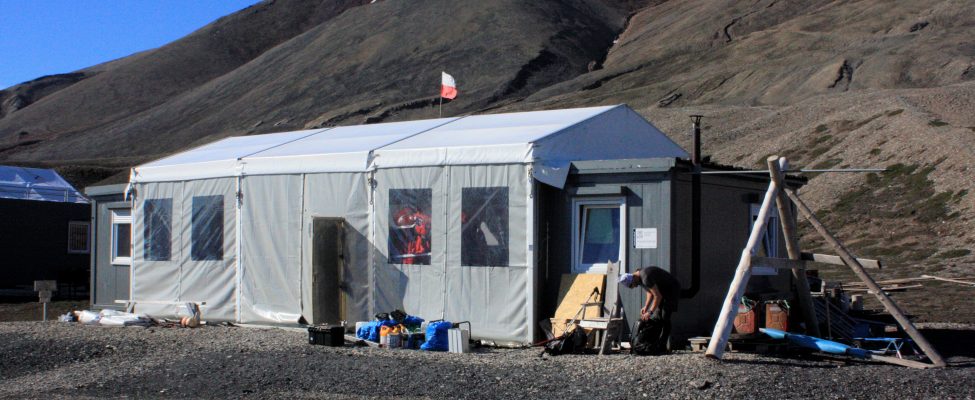
History and facilities

Adam Mickiewicz University staff has studied the area since 1984, using the old hut &ldquo;Skottehytta&rdquo; as a base until 2009. In 2011, a temporary station was built nearby. It was moved to the western coast of the bay and expanded to the current size in 2015. The station consists of two 10 m2 bedroom barracks and one kitchen/living room/laboratory facility (18 m2). In between them, during the summer, a tent hall (40 m2) is raised. Electricity is from fossil fuel generator (230 V) and solar panels (12 V). Supplies to the station (equipment, food and fuel) are brought from Poland at the beginning of summer or bought in Longyearbyen.

General research and databases

Scientific investigations at the station are cover monitoring of both biotic and abiotic compartments of the natural environment. Meteorological surveys are based on stationary observations at the station, as well as automatic weather stations around the bay. Sites of permafrost studies, comprising ground temperature measurements are established and during the summer glaciological, hydrological, geomorphological, geological, geochemical, botanical observations are performed. Data are acquired according to standards of the Polish Governmental Integrated Monitoring system.

Station Monitoring

Human dimension

In the vicinity of the station, remnants of the Russian coal mine, Pyramiden - abandoned in 1998, are visible. Nowadays Pyramiden (about 20 people) is operated mostly for tourists. In Pyramiden there is a helipad, hotel and bar. Currency &ndash; NOK, cash only.<br />The capital of Svalbard, Longyearbyen (&gt;2000 inhabitants), is located 60 km from the station. Longyearbyen has all facilities including airport, harbour, hospital, markets, hotels, gas station etc. Currency in operation is NOK, ATM is also available.

Access

Svalbard is accessible for scientific research based on the Svalbard Treaty (since 1920). Svalbard Environmental Protection Act established a number of national parks, although, the nearest area of the station is open for visitors without special permits. Research projects need to be registered. More info www.sysselmannen.no.<br />The most convenient way to access Longyearbyen is by regular flights from Norway. From Longyearbyen you can get to the station in summer by daily tourist ships (one way trip 4-5 hours) to Pyramiden in the morning and in the afternoon. Finally to get to the station from the pier in Pyramiden (4 km from the station). It takes up to one hour walking or faster by zodiac, if arranged prior to arrival. When transporting larger volumes of cargo, shipping from Poland is possible with arrival around the end of June. Zodiac boats are used for transportation within the fiord. On land, only walking is allowed

Member of: