Address

Station manager

Ireneusz Sobota
E-mail: irso@umk.pl

Contact Station

E-mail: nozigp@umk.pl

www.geo.umk.pl

Station Features

Opening year: 1975 Status: Open
  • Type of station: Station
  • Operational period – year-round or Month A to Month B: March - September
  • Name of station owner: Polar Research Center, Nicolaus Copernicus University in Torun, Poland.
  • Type of owner: Government
  • Name of managing institution: Nicolaus Copernicus University
  • Managing Institution Country: Poland
  • Station owner country: Poland
  • Partner institution: No
  • Station latitude: 78,67573227
  • Station longitude: 11,82658719
  • Country (station location): Svalbard and Jan Mayen Islands
  • Altitude of station: 2 m a.s.l
  • Min. altitude within study area: 0 m a.s.l
  • Max. altitude within study area: 700 m a.s.l
  • Nearest town/settlement: Ny Ålesund
  • Distance to nearest town/settlement: 100 km
  • Number of residents in nearest town: 2100
  • Distance to nearest public transport facility (Airport, Ferry terminal, Train station, Bus station): 100 km
  • Distance to nearest research station: 28 km
  • Maps available at station: Aerial images, satellite images, google earth, thematic maps
  • Type of surface facility is built on: Rock
  • Landscape features Mountains, Valleys, Lake, River, Sea
  • Permafrost zone Continuous
  • Snow and ice on land Ice Caps, Glaciers
  • Vegetation zone Gramminoid tundra, Peatlands/mires

Facilities

  • Area under roof: 100 m²
  • Max. number of visitors at a time : 15
  • Showers: Yes
  • Laundry facilities: Yes
  • Power supply – period (from ‘hour’ to ‘hour’ or 24 hours): 6 Hours, more if needed
  • Power supply - plug type C
  • Power sources at station Other
  • Number of staff peak season/summer: 2
  • Number of staff off season/winter: 0
  • Logistics area: 48 m²
  • Conference room capacity: 0
  • Workshops Metal, Wood
  • Means of transportation to/from station Boat, Chartered plane/helicopter
  • Air transport landing facilities at station Airstrip, Helipad
  • Airstrip surface : Gravel/Sand
  • Transport on land - at station Snowmobile
  • Transport on water - at station Zodiac, Open boat/Dhinghy, Other
  • Water landing facilities Pontoon/float bridge
  • Compulsory safety equipment VHF, Satellite phone, GPS, Weapon/rifle, Flare gun, Other
  • Laboratory area: 10 m²
  • Field to station VHF, Satellite phone
  • Station to outside world Other
  • IT Infrastructure Computers
  • Medical facilities: Yes
  • Medical capability Basic
  • Staff with medical training/doctor No
  • Distance to hospital (estimated time – hours): 100

Science

  • Transnational Access: No
  • Remote Access: No
  • INTERACT Virtual Access: No
  • Housing and accomodation
    • Showers
    • Laundry facilities
    • A
    • B
    • C
    • D
    • E
    • F
    • G
    • H
    • I
    • J
    • K
    • L
    • M
    • N
    • O
    • Municipal grid
    • Diesel/oil/gas
    • Wood
    • Solar
    • Wind
    • Water
    • Geothermal
    • Biofuel
    • Other
  • Communication
    • Telephone
    • Satellite phone
    • VHF
    • E-mail
    • Internet
    • Computer
    • Printer
    • Scanner
    • Fax
  • Permitting issues categories
    • Permits required for studies
    • Permits required for access to the station
  • Main science disciplines
    • Astronomy
    • Atmospheric sciences
    • Cryology
    • Geology
    • Hydrology
    • Limnic biology
    • Marine biology
    • Terrestrial biology
    • Human biology
    • Anthropology
    • Archaeology
    • Sociology
    • Climate change
    • Environmental science (incl. pollution)
    • Oceanography
    • Agriculture
    • Animal husbandry
    • Fisheries
    • Forestry
    • Hunting
    • Tourism
  • Meteorology
    • Air temperature
    • Air humidity
    • Air pressure
    • Wind velocity
    • Wind direction
    • Precipitation
  • Sub-surface characteristics
    • Ground surface temperature
    • Soil temperature
    • Soil moisture
    • Ground water table
    • Soil water chemistry
    • Active layer depth
    • Permafrost distribution
    • Permafrost thickness
    • Permafrost temperature
  • Snow characteristics
    • Snow depth
    • Snow cover
    • Snow density
    • Snow temperature
  • Hydrology/Limnology
    • River water discharge/water level
    • Lake water level
    • Water balance
    • Water temperature
    • Lake ice cover (formation/breakup/thickness)
    • Suspended sediment discharge
    • Organic matter discharge
    • PAR (Photosyntetically Active Radiation)/secchi depth
    • Water chemistry
  • Glacier characteristics
    • Glacier area
    • Topography
    • Elevation change
    • Terminus position
    • Ice velocity
    • Ice thickness
    • Debris cover
    • Surface albedo/reflexion coefficient
  • Mass balace
    • Mass balance
    • Snow water equivalent
    • Snowcover stratigraphy
    • Equilibrium Line Altitude
    • Duration of snow cover
    • Calving flux
  • Climate
    • Climate measurements
    • Energy balance
  • Glacier hydrology
    • Run-off
    • Supra-, en- and subglacial drainage system
    • Meltwater retention
    • Glacial lake outburst floods
  • Energy balance and radiation
    • Energy balance
    • Short wave incoming
    • Short wave outgoing
    • Long wave incoming
    • Long wave outgoing
    • Net radiation
    • UV-B
    • Multi-spectral
    • Cloud cover/hours of sunshine
  • Geology/Geomorphology
    • Quaternary geology
    • Sedimentology
    • Bedrock geology
    • Erosion
  • Vegetation
    • Flowering phenology
    • Amount of flowering
    • NDVI (plot/transect)
    • Landscape NDVI (from satellite images)
    • Vascular plant community composition
    • Bryophyte community composition
    • Lichen community composition
    • Fungi community composition
    • Berry production
    • Aerobiological monitoring (pollen, spores, etc.)
    • Species list (community composition)
  • Partner institutions (involved in the operation of the station)
    • Partner institution
  • Climate
    • Snow
    • Rain
    • Hail
  • Landscape and environment
    • Mountains
    • Nunataks
    • Volcano/crater
    • Lava fields
    • Plateaus
    • Moraines
    • Valleys
    • Homothermic Springs
    • Lake
    • Thermokarst lake
    • River
    • Delta/estuarie
    • Fjord
    • Sea
    • Continuous
    • Discontinuous
    • Beach
    • Sporadic
    • Rocky shores
    • Pingos/ice lenses
    • Sea cliffs
    • Other (text)
    • Palsa mires
    • Ice Caps
    • None
    • Glaciers
    • Permanent snow patches
    • None
    • Tree line
    • Polar desert/Semi-desert
    • Gramminoid tundra
    • Shrub tundra
    • Forest tundra
    • Wetlands
    • Peatlands/mires
    • Salt marshes/lagoons
    • Heath
    • Grassland
    • Deciduous forest
    • Evergreen forest
    • Terrestrial carnivores
    • Alpine heath
    • Ungulates
    • Hares
    • Other (text)
    • Rodents
    • Bird colonies
    • Polar bear
    • Whales
    • Seals
    • Fish
    • Settlement
    • Fishing
    • Hunting
    • Forestry
    • Agriculture
    • Tourism
    • Animal husbandry
    • Leisure activities
  • Logistics
    • Electrical and IT technologies
    • Mechanical
    • Metal
    • Wood
    • Plexiglas
    • Other
    • Walk
    • None
    • Tracked vehicle
    • Truck
    • SUV (4x4)
    • Car
    • Zodiac
    • ATV
    • Snowmobile
    • Open boat/Dhinghy
    • Closed boat
    • Bicycles
    • Amphibie vehicle
    • Ski
    • Other
    • Snow shoes
    • KickSledges
    • Other
    • Ski
    • Snowmobile
    • Boat
    • Car
    • Tracked vehicle
    • Truck
    • SUV (4x4)
    • Bus
    • Train
    • Airstrip
    • Scheduled flight
    • Chartered plane/helicopter
    • Helipad
    • None
    • Other
    • Harbour/port
    • Warf/pier
    • Pontoon/float bridge
    • Barges
    • Beach
  • Field equipment
    • PLB
    • VHF
    • HF
    • Satellite phone
    • Mobile phone
    • GPS
    • Weapon/rifle
    • Flare gun
    • Bearspray
    • PLB
    • First aid kit
    • Glacier rescue kit
    • VHF
    • Avalanche rescue kit
    • HF
    • Satellite phone
    • Overnight equipment
    • Other
    • Mobile phone
    • GPS
    • Weapon/rifle
    • Flare gun
    • Bearspray
    • PLB
    • First aid kit
    • Glacier rescue kit
    • VHF
    • Avalanche rescue kit
    • HF
    • Satellite phone
    • Overnight equipment
    • Other
    • Mobile phone
    • GPS
    • Weapon/rifle
    • Flare gun
    • Bearspray
    • Tent
    • First aid kit
    • Glacier rescue kit
    • Sleeping matress
    • Avalanche rescue kit
    • Sleeping bag
    • Cooking equipment and utensils
    • Overnight equipment
    • Other
    • Gas/alcohol for cooking
    • Field power supply available at station
  • Laboratory
    • Freezer < -80
    • Freezer -40 - -10
    • Fridge
    • Microscopes
    • Basic laboratory equipment
    • Advanced laboratory equipment
    • Basic chemical reagents
    • Analytical instrumentation
    • Other
    • Laboratory available in nearby town/settlement
  • Communication and IT
    • Mobile phone
    • VHF
    • Satellite phone
    • Other
    • Satellite phone
    • Mobile phone
    • Internet
    • Other
    • Wireless transfer of data from field site to station
    • Wifi
    • Computers
    • Printer
    • Data storage
    • Statistical tools
    • GIS tools
    • Other
  • Medical facilities
    • Medical facilities
    • Basic
    • Medium
    • Extensive
    • Dental
    • Surgery
    • Other
    • No
    • In peak season
    • When open

Station name and owner

Nicolaus Copernicus University Polar Station “Hahut”, Svalbard (NCUPS) is owned by Nicolaus Copernicus University in Torun, Polar Research Center, Poland.

Location

The station is located in the western part of the Oscar II Land, in the northern part of the coastal Kaffiøyra Lowland, in north-western Spitsbergen. The station was established about 150 m from the shoreline, at the terminal moraines of Aavatsmarkbreen. Svalbard is accessible for scientific research based on the Svalbard Treaty (since 1920). Svalbard Environmental Protection Act determined the erection of national parks. The station is its location outside any nature parks and reserves, and this allows a relatively high degree of freedom to move around and do research in the area, and it is open for visitors without special permits. Research projects need to be registered. The nearest civilian settlement is Longyearbyen, 100 km south of the Kaffiøyra region.

Climate data

Grey colours are WMO Climate Normals including maximum and minimum values. Blue colours are individual years.

Climate data for the stations where extracted via Copernicus Climate Data Store, from the global gridded reanalysis product: ERA5 monthly averaged data on single levels from 1940 to present. Description and source code: Roemer J.K. 2023. https://doi.org/10.5281/zenodo.10214922 Data Source: Hersbach et al. 2023. Copernicus Climate Change Service (C3S) Climate Data Store (CDS), https://doi.org/10.24381/cds.f17050d7

Biodiversity and natural environment

The surrounding environment is determined by High Arctic conditions (>78°N). The average temperature of air in the Kaffiøyra region in summer is 5.4 °C and the significant air temperature increase is observed, reaching 0.28°C/10 years. The mean annual mass balance of glaciers is about -1.0 m w.e. The permafrost is thawing to the depth above 2.0 m. High Arctic tundra characteristic plants are dwarf shrubs and mosses. The area around the station hosts various birds, reindeers, arctic foxes, seals and polar bears.

History and facilities

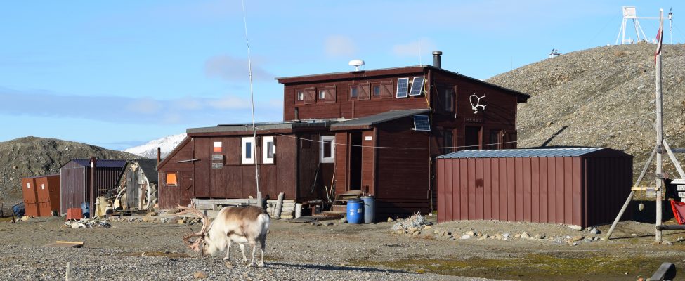
NCU Polar Station was established in 1975. The station consists of 32 m2 of floor space downstairs and 24 upstairs. There is the main room, a workshop, a bedroom, two mezzanine sleeping areas, and a fully equipped kitchen and lab, and an extra bedroom for 6 persons. There are also additional storage areas, another lab, a bathhouse, a lavatory, and garages for boats and motors. Now, the total useable floor space of all rooms and outbuildings is more than 100 m2. The station is furnished with all the necessary technical equipment, such as generator sets, photovoltaic cells, and motorboats and others. There is enough safety equipment to provide the necessary protection while working on glaciers or on water. This includes radio and satellite communication equipment, and appropriate firearms to be able to respond to potential threats from polar bears.

General research and databases

Scientific programs emphasize on research in glaciology, hydrology, glacial geomorphology, permafrost and periglacial processes, as well as climatologic and botanical studies. Since 1996 glaciological research and the studies of permafrost of various ground types and their seasonal thawing, as well as meteorological observations are the major issues on the research agenda. The results of glaciological, meteorological and permafrost studies to date have made it possible to obtain some of the longest data series available for Svalbard today. Monitoring of contemporary changes in the cryosphere and standard meteorological observations are being conducted, including using automatic weather stations operating all year round. Investigations conducted at the station are covering the monitoring of the natural environment in its abiotic and biotic parts.

Station Monitoring

Human dimension

The nearest settlement is Ny-Ålesund, a major international research centre. Forlandsundet is used by small ships travelling between Longyearbyen and Ny-Ålesund. Svalbard capital Longyearbyen is a common place of arrival on the archipelago by regular flights from Norway or by ships. Longyearbyen with its over 2000 inhabitants has all facilities including airport, harbour, hospital, markets, hotels, gas station etc. From Longyearbyen to the station the transportation can be organized by ship companies.

Access

There is an international airport in Longyearbyen with scheduled connections to mainland Norway. From there to the station ship transport is possible during summer (about 4-12 hours). There is also possible to get to Ny-Ålesund, and from this settlement to the station by boat or snowmobiles during spring. From Longyearbyen an air shuttle service normally twice a week connects Longyearbyen with Ny-Ålesund. The flight takes approximately 25 minutes with normally max. 14 persons per flight. The transportation of a larger amount of cargo, shipping from Poland is possible about the end of June.

Member of: