Address

Station manager

Susanne Hanson
E-mail: suha@dtu.dk

Contact Station

E-mail: arctic@dtu.dk

www.arctic.dtu.dk

Station Features

Opening year: 2018 Status: Open
  • Type of station: Station
  • Operational period – year-round or Month A to Month B: Year-round
  • Name of station owner: Arctic DTU, ARTEK
  • Type of owner: Research institution
  • Name of managing institution: Technical University of Denmark
  • Managing Institution Country: Denmark
  • Station owner country: Greenland
  • Partner institution: No
  • Station latitude: 66,93570560
  • Station longitude: -53,67305000
  • Country (station location): Greenland
  • Altitude of station: 35 m a.s.l
  • Min. altitude within study area: 0 m a.s.l
  • Max. altitude within study area: 1648 m a.s.l
  • Nearest town/settlement: Sisimiut
  • Distance to nearest town/settlement: 0 km
  • Number of residents in nearest town: 6500
  • Distance to nearest public transport facility (Airport, Ferry terminal, Train station, Bus station): 0 km
  • Distance to nearest research station: 265 km
  • Type of surface facility is built on: Rock
  • Maps available at station: Maps (1:30 000 , 1:100 000, 1:250 000), air photos, satellite images
  • Climate zone: Low Arctic
  • Mean annual temperature: -3,6 °C
  • Mean temperature in February: -13,9 °C
  • Mean temperature in July: 7,1 °C
  • Precipitation type: Snow, Rain
  • Sea ice break up: May, June
  • Maximum wind speed (absolute): 50 m/s
  • Landscape features Mountains, Valleys, Lake, River, Fjord, Sea
  • Permafrost zone Continuous, Discontinuous
  • Snow and ice on land Ice Caps, Glaciers, Permanent snow patches
  • Vegetation zone Polar desert/Semi-desert, Gramminoid tundra, Forest tundra, Peatlands, Wetlands
  • Wildlife Ungulates, Whales, Seals, Fish
  • Human use Settlement, Fishing, Hunting, Tourism

Facilities

  • Number of staff peak season/summer: 2
  • Number of staff off season/winter: 2
  • Staff able to assist (fieldwork): Yes - if time allows
  • Staff able to assist (workshops): Yes - if time allows
  • Area under roof: 350 m²
  • Max. number of visitors at a time : 20
  • Showers: Yes
  • Laundry facilities: Yes
  • Power supply – period (from ‘hour’ to ‘hour’ or 24 hours): 24 Hours
  • Power supply - plug type C, E, F, K
  • Logistics area: 200 m²
  • Conference room capacity: 30
  • Workshops Metal, Plexiglas, Wood
  • Air transport landing facilities at station Airstrip
  • Airstrip surface : Tarmac/Concrete
  • Transport on land - at station ATV, Snowmobile, Car
  • Transport on water - at station Closed boat
  • Water landing facilities Pontoon/float bridge
  • Laboratory area: 100 m²
  • Laboratory equipment Freezer -40 - -10, Fridge, Microscopes, Basic laboratory equipment, Basic chemical reagents
  • Laboratory available in nearby town/settlement: Yes
  • Medical facilities: Yes
  • Medical capability Basic, Medium, Extensive, Dental
  • Staff with medical training/doctor When open
  • Distance to hospital (estimated time – hours): 0
  • Compulsory safety equipment Satellite phone, First aid kit
  • Recommended safety equipment Satellite phone, First aid kit, Overnight equipment
  • Safety equipment available at station Satellite phone, Mobile phone, GPS, First aid kit, Glacier rescue kit, Avalanche rescue kit, Overnight equipment, Other
  • Camping equipment available at station Tent, Sleeping matress, Sleeping bag, Cooking equipment and utensils, Gas/alcohol for cooking
  • Field power supply available at station: Yes
  • Field to station Satellite phone
  • Station to outside world Mobile phone, Internet
  • IT Infrastructure Wifi, Computers, Printer, Data storage, Statistical tools, GIS tools

Science

  • Transnational Access: No
  • Remote Access: No
  • INTERACT Virtual Access: No
  • Partner institutions (involved in the operation of the station)
    • Partner institution
  • Climate
    • Snow
    • Rain
    • Hail
  • Landscape and environment
    • Mountains
    • Nunataks
    • Volcano/crater
    • Lava fields
    • Plateaus
    • Moraines
    • Valleys
    • Homothermic Springs
    • Lake
    • Thermokarst lake
    • River
    • Delta/estuarie
    • Fjord
    • Sea
    • Continuous
    • Discontinuous
    • Beach
    • Sporadic
    • Rocky shores
    • Pingos/ice lenses
    • Sea cliffs
    • Other (text)
    • Palsa mires
    • Ice Caps
    • None
    • Glaciers
    • Permanent snow patches
    • None
    • Tree line
    • Polar desert/Semi-desert
    • Gramminoid tundra
    • Shrub tundra
    • Forest tundra
    • Wetlands
    • Peatlands/mires
    • Salt marshes/lagoons
    • Heath
    • Grassland
    • Deciduous forest
    • Terrestrial carnivores
    • Evergreen forest
    • Ungulates
    • Alpine heath
    • Hares
    • Other (text)
    • Rodents
    • Bird colonies
    • Polar bear
    • Whales
    • Seals
    • Fish
    • Settlement
    • Fishing
    • Hunting
    • Forestry
    • Agriculture
    • Tourism
    • Animal husbandry
    • Leisure activities
  • Housing and accomodation
    • Showers
    • Laundry facilities
    • A
    • B
    • C
    • D
    • E
    • F
    • G
    • H
    • I
    • J
    • K
    • L
    • M
    • N
    • O
    • Municipal grid
    • Diesel/oil/gas
    • Wood
    • Solar
    • Wind
    • Water
    • Geothermal
    • Biofuel
    • Other
  • Logistics
    • Electrical and IT technologies
    • Mechanical
    • Metal
    • Wood
    • Plexiglas
    • Other
    • Walk
    • None
    • Tracked vehicle
    • Truck
    • SUV (4x4)
    • Car
    • ATV
    • Zodiac
    • Snowmobile
    • Open boat/Dhinghy
    • Closed boat
    • Bicycles
    • Amphibie vehicle
    • Ski
    • Other
    • Snow shoes
    • KickSledges
    • Other
    • Ski
    • Snowmobile
    • Boat
    • Car
    • Tracked vehicle
    • Truck
    • SUV (4x4)
    • Bus
    • Train
    • Airstrip
    • Scheduled flight
    • Chartered plane/helicopter
    • Helipad
    • None
    • Other
    • Harbour/port
    • Warf/pier
    • Pontoon/float bridge
    • Barges
    • Beach
  • Laboratory
    • Freezer < -80
    • Freezer -40 - -10
    • Fridge
    • Microscopes
    • Basic laboratory equipment
    • Advanced laboratory equipment
    • Basic chemical reagents
    • Analytical instrumentation
    • Other
    • Laboratory available in nearby town/settlement
  • Medical facilities
    • Medical facilities
    • Basic
    • Medium
    • Extensive
    • Dental
    • Surgery
    • Other
    • No
    • In peak season
    • When open
  • Field equipment
    • PLB
    • VHF
    • HF
    • Satellite phone
    • Mobile phone
    • GPS
    • Weapon/rifle
    • Flare gun
    • Bearspray
    • PLB
    • First aid kit
    • Glacier rescue kit
    • VHF
    • Avalanche rescue kit
    • HF
    • Satellite phone
    • Overnight equipment
    • Other
    • Mobile phone
    • GPS
    • Weapon/rifle
    • Flare gun
    • Bearspray
    • PLB
    • First aid kit
    • Glacier rescue kit
    • VHF
    • Avalanche rescue kit
    • HF
    • Satellite phone
    • Overnight equipment
    • Mobile phone
    • Other
    • GPS
    • Weapon/rifle
    • Flare gun
    • Bearspray
    • Tent
    • First aid kit
    • Glacier rescue kit
    • Sleeping matress
    • Avalanche rescue kit
    • Sleeping bag
    • Cooking equipment and utensils
    • Overnight equipment
    • Other
    • Gas/alcohol for cooking
    • Field power supply available at station
  • Communication and IT
    • Mobile phone
    • VHF
    • Satellite phone
    • Other
    • Satellite phone
    • Mobile phone
    • Internet
    • Other
    • Wireless transfer of data from field site to station
    • Wifi
    • Computers
    • Printer
    • Data storage
    • Statistical tools
    • GIS tools
    • Other

Station name and owner

Arctic DTU operates and run the 
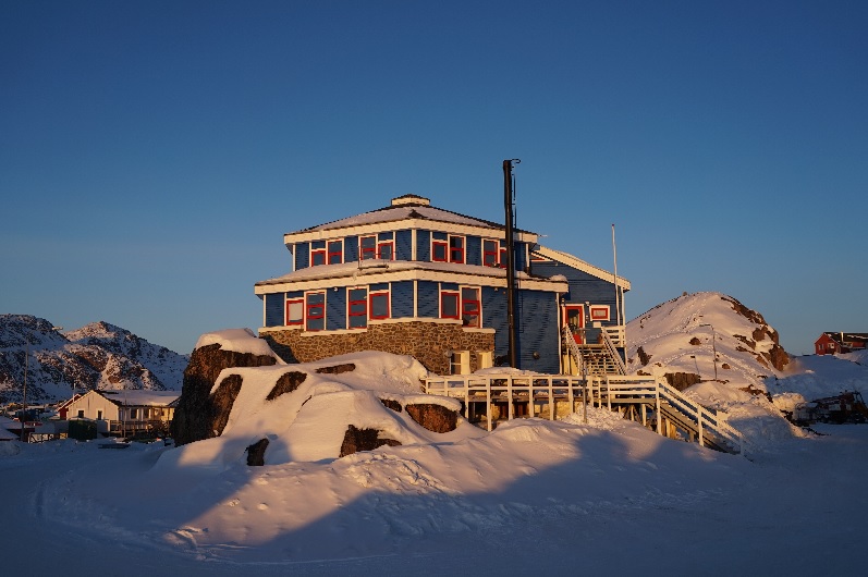
Arctic DTU Research Station. The station is part of a cooperation between the Technical University of Denmark (DTU) and the Government of Greenland on Arctic educations, research and innovation. Buildings are owned by the Government of Greenland and provided by KTI – Tech College Greenland, the technical vocational school of Greenland.

Location

The station is situaded in Sisimiut, the second largest town of Greenland with app. 5500 inhabitants. The town is located 75 km north of the Arctic Circle on the central-western coast of Greenland along the east shore of Davis Strait. Sisimiut is the northernmost year-round ice free city in Greenland. The main occupation is fishing industry, trade, public services, tourism and education / research.

Climate data

Grey colours are WMO Climate Normals including maximum and minimum values. Blue colours are individual years.

Climate data for the stations where extracted via Copernicus Climate Data Store, from the global gridded reanalysis product: ERA5 monthly averaged data on single levels from 1940 to present. Description and source code: Roemer J.K. 2023. https://doi.org/10.5281/zenodo.10214922 Data Source: Hersbach et al. 2023. Copernicus Climate Change Service (C3S) Climate Data Store (CDS), https://doi.org/10.24381/cds.f17050d7

Biodiversity and natural environment

Sisimiut is situated between sea, mountains, tundra and ice. The research station is surrounded to the west by David Strait and to the south by peninsulas and archipelagos. To the north and east of the city vast areas of mountains, lakes and arctic tundra stretches all the way to Kangerlussuaq (130 km) and further 40 km to the Greenlandic Icecap. The landscape around the station is the largest ice free area in Greenland. Birdlife are breeding in the nearby mountains along the coastline. Reindeer, foxes, musk ox, seals and whale are living near the city. Rarely polar bears are spotted north of town. Sisimiut is the southernmost town in Greenland where sledge dogs are allowed and has ~ 1000 of sledge dogs.

History and facilities

The station itself started as a cooperation between Greenlandic Government and DTU on arctic technical education in 2000, based on fieldwork and research conducted in the area. Around 75 international arctic students visit the place over the year. Today, the station also is our base for international multidisciplinary research and fieldwork conducted in the surroundings and backcountry of Sisimiut. We provide logistical support (4WD carssnowmobile, ATV, equipment and charter of boat), workshops, office facilities and field storage, while laboratory access often can be arranged. We have apartments and rooms with a total of 20 beds while additional rooms can be arranged through our local partners. Moreover we have access to a number of bivouac shelters in the back country and we have a small hut in Kangerlussuaq mainly for monitoring of permafrost, northern light and glacial earthquakes.

General research and databases

The research station is situated between sea, tundra and ice and is situated ideal for multidisciplinary research and long-term monitoring of geophysical changes related to climate change including terrestrial and aquatic ecosystems and Earth Observation (EO). Further, research related to arctic settlements, infrastructure and environmental impact is performed, so also research in arctic heritage in connection with the area being added to the UNESCO World Heritage list in 2018.

Station Monitoring

Human dimension

The station is located in one of the larger towns in Greenland, Sisimiut. The research station is accessible all year for both researchers and university students.

Access

Sisimiut is reached either by plane or boat. By plane with almost daily connections operated by Air Greenland from either Nuuk, Aasiaat or Kangerlussuaq, the international airport of Greenland. The Arctic Trail, a 160 km hike trail, connects Sisimiut with Kangerlussuaq. Arctic Umiaq Line operates a coast ferry with one all-year-round weekly connection southbound to Nuuk and Qaqortoq and one weekly connection northbound to Ilulissat during the summer season.

Member of: